Cristobal’s Storm Surge Floods Fowl River Marina Pier
Tropical Storm Cristobal sent a five-foot storm surge over the Fowl River marina pier in Mobile County, swamping docks as most boats escaped ahead of the.
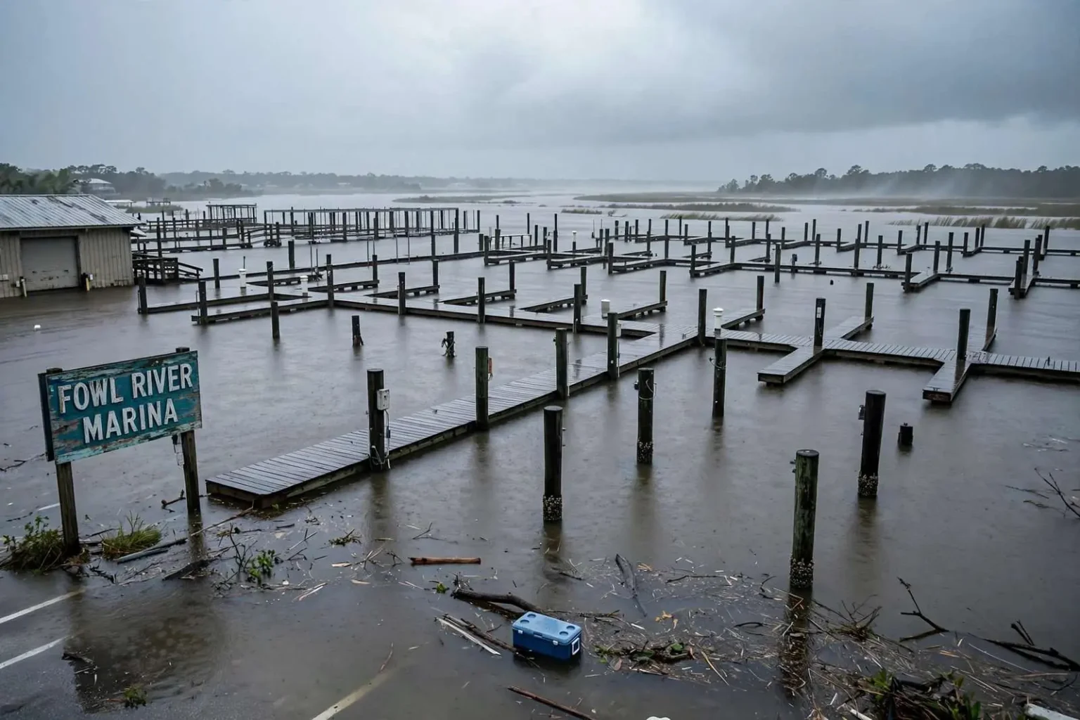
MOBILE COUNTY, Ala. — Tropical Storm Cristobal pushed water over the pier at a Fowl River marina on Sunday, June 7, 2020, as rain and storm surge from the Gulf combined to swamp the popular boating spot south of Mobile.
By midday the surge had risen high enough that some of the marina’s pier pilings were barely poking above the waterline, leaving docks and walkways half-drowned as wind pushed bay water inland across the low-lying shoreline communities that line the river’s mouth.
One boat owner at the docks estimated the surge had climbed to around five feet — the highest he had seen it there in some time. Water that high does not simply lap over a pier; it floods storage areas, floats fuel docks and turns parking lots into shallow bays, complicating any last-minute attempts to move or secure vessels.
There was at least one bit of good luck: most of the boats that normally berth at the marina had been moved before the storm arrived, leaving fewer vessels exposed to the rising water. Boat owners along Mobile Bay’s western shore have learned through repeated storms that hauling a boat early is cheaper than repairing one late, and the empty slips on Sunday suggested that lesson had taken hold.
Where Fowl River sits on the map
Fowl River flows into the northwestern corner of Mobile Bay between the communities of Theodore and Coden, and its lower reaches are lined with marinas, camps and seafood businesses that live by the water. The area’s low elevation means storm surge from the Gulf — and wind-driven water from the bay itself — reaches streets and docks there long before conditions turn dangerous farther north.
Surge on the western shore of Mobile Bay behaves differently from the open Gulf beaches. Water pushed into the broad, shallow bay piles against the shoreline and funnels up tidal rivers like Fowl River, so communities a dozen miles from the beachfront can see water over their docks even in storms that never come close to hurricane strength.
That pattern repeated across the weekend, with the heaviest coastal impacts along bayside communities like Fowl River, Coden and Mon Louis Island — a string of shoreline neighborhoods south of Mobile where residents watch the tide gauges and each other’s docks whenever a tropical system enters the central Gulf.
An unusual storm track
Cristobal made landfall in southeastern Louisiana before swinging north toward the Gulf Coast, spreading bands of rain and onshore flow across coastal Alabama throughout the weekend. The storm had an unusual history even by the standards of an already strange hurricane season, forming from the remnant circulation of Tropical Storm Amanda, which had drenched Central America after forming in the eastern Pacific.
After crossing into the Bay of Campeche, the system reorganized, earned the Atlantic name Cristobal, and made it the earliest third named storm on record in the Atlantic basin — a mark noted widely at the time as 2020’s hurricane season sprinted through the alphabet months ahead of the historical pace.
The track into southeastern Louisiana put coastal Alabama on the storm’s weaker eastern side, but geography made that a relative term. Onshore flow out of the south and southeast pushed Gulf water into the shallow bays and sounds east of the Mississippi River for two full days, and the flooding that resulted was driven as much by duration as by wind speed.
That is the classic recipe for surge trouble on the northern Gulf Coast: a storm does not need to be intense if it moves slowly and pushes water in the same direction through several tide cycles. Communities on the western shore of Mobile Bay, including Fowl River, Coden and Mon Louis Island, sat squarely in the path of that piled-up water.
Life along the western shore
The communities taking on water Sunday are small but deeply tied to the bay. Coden and Mon Louis Island anchor a stretch of shoreline where fishing families, boat owners and weekend campers have shared the waterfront for generations, and a marina pier is as much a neighborhood gathering place as a commercial asset.
Storm experience shapes how the area prepares. Longtime residents move boats to higher water or haul them out entirely, raise equipment off garage floors, and wait out the surge rather than driving through flooded roads to check on property. Emergency officials repeat the same warning every coastal event: most storm deaths on the northern Gulf Coast involve water, either surge or flooded roads, and sightseeing drives through high water put rescuers at risk along with the drivers.
By the standards of a named storm’s arrival, the marina’s losses Sunday appear to have been limited by the early moves of boat owners. Property along the western shore has absorbed far worse from stronger storms, but every event leaves its cleanup — soaked dock boards, silt lines on pilings, debris to clear before the next weekend’s fishing runs.
Cristobal’s weekend visit served as an early reminder, in a season that would go on to set records for named storms, that south Alabama’s flooding risk begins well before hurricane strength. Water over a Fowl River pier from a tropical storm is the same mechanism, at smaller scale, that reshapes coastlines when the big ones arrive.
What the surge means for boaters
For marina operators and boat owners, a five-foot surge is a working problem with a familiar checklist. Pilings and dock cleats take the strain of boats rising on their lines; fuel systems and electrical panels near the waterline need to be de-energized and inspected before use; and anything stored dockside — crab traps, nets, tools, coolers — floats away unless it was tied down.
The aftermath is usually measured in days rather than months for an event of this size. Once the water withdraws, crews clear debris from the pier, check planking and fasteners for damage, and owners who kept their boats in the water inspect hulls and lines. Insurance adjusters handle the rest, and the marina returns to its normal rhythm well before summer’s peak boating season slips past.
The bigger worry for the boating community is repetition. Fowl River and the surrounding western shore have taken surge from tropical systems repeatedly over the decades, and each episode adds to the case for elevated storage, stronger pilings and the habit of moving vessels early when any Gulf system takes aim at the northern coast.
The season’s early pace
Cristobal’s landfall came weeks before the climatological start of peak hurricane season, and its weekend effects on coastal Alabama were felt while residents were still adjusting to a spring shaped by the coronavirus pandemic. Shelters, evacuations and storm preparations that summer all carried public health complications that emergency managers had never planned for at scale.
For coastal Alabama, though, the storm itself was a modest test. Rain bands moved through, winds gusted, water rose over low-lying docks and roads — and by the following week, the region had largely dried out. The lesson residents took from it was less about damage than about vigilance: the season ahead had a long way to run, and the water at a Fowl River marina showed how quickly a routine June weekend could turn.
Sunday’s images of submerged pilings and empty slips told the story of a community that has learned its shoreline. The water came as forecast, the boats were mostly gone before it arrived, and the pier that disappeared beneath the surge reappeared as the tide receded, ready for the next launch.
How surge forecasts reach the docks
The water that swallowed the Fowl River pier Sunday was foreseen days in advance, even if its exact height was not. National Weather Service forecasters in Mobile issue coastal flood watches and warnings for Mobile Bay and its tidal rivers when onshore flow and astronomical tide patterns combine, and those bulletins travel the usual routes — local media, weather apps, marina message boards and the informal phone tree of boat owners checking on one another.
Surge forecasting on the northern Gulf Coast has improved dramatically over the decades, with computer models simulating how wind-driven water piles into the shallow bay and which shoreline streets flood first. What the models cannot predict is the human element: which boat owners will haul out early, which camp residents will ride out the surge, and how many drivers will risk the flooded road that always looks passable until it is not.
Local emergency management agencies use the forecasts to position high-water rescue teams and close the roads that consistently flood, several of which serve the western shore communities south of Mobile. Residents learn those closures by heart over the years, and the ones who ignore them create most of the storm-day work for first responders.
Looking past the water
Once Cristobal’s moisture moved north and the weekend ended, attention along the western shore turned to the routine business of drying out and assessing. Docks that spent a day underwater get inspected for scouring around their pilings, where moving water quietly undermines the structures that keep a pier standing, and electrical systems get checked before anyone plugs in at the fuel dock again.
For the communities of Fowl River, Coden and Mon Louis Island, the episode added one more entry to a long ledger of Gulf storms great and small. None of them mistake a tropical storm for a hurricane, but they know the bay’s habits: the water goes where the wind sends it, it stays longer than visitors expect, and the shoreline that floods first recovers first when the wind finally turns.
The marina pier that vanished under a Sunday tide was back above the waterline within a day, and the boats that had been moved early were eased back into their slips for a summer of fishing that Cristobal, for all its early-season surprise, only briefly interrupted.