
Dauphin Island Mayor Tells West End Residents and Visitors to Get Out Ahead of Sally
As Tropical Storm Sally approached, Dauphin Island's mayor urged west end residents and visitors to evacuate as saltwater flooding began.
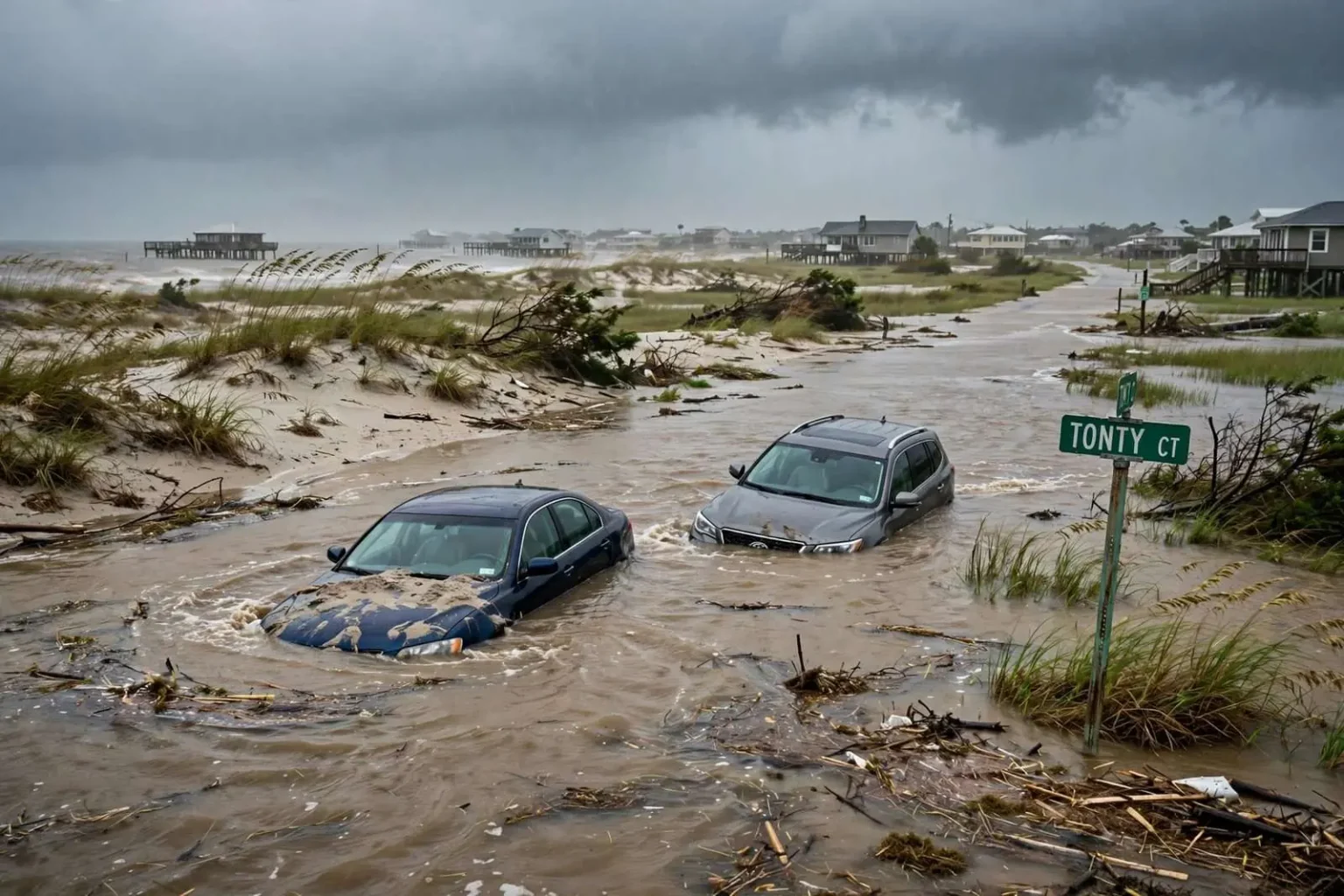
Dauphin Island Mayor Jeff Collier urged residents and visitors to evacuate the west end of the island Monday as Tropical Storm Sally closed in on the Gulf Coast and saltwater flooding began to push onto roads. In a Facebook post, Collier cited rising water, high winds, heavy surf and an imminent cut to water service, writing that people should move to higher ground as soon as possible.
The warning came well before landfall, and that timing was the point. Sally was a slow-moving system crawling toward the northern Gulf Coast, which meant its surge, winds and rain would punish exposed shorelines for an extended period — and low-lying barrier islands feel those effects hours before the storm’s official arrival. Collier’s message was blunt: once the water began moving across the island’s roads, the window for leaving was closing, and those who stayed would be on their own for the duration.
He warned that conditions were deteriorating to the point where first responders would no longer be able to reach parts of the west end to provide emergency assistance. For a barrier island community, that threshold — the moment when rescue becomes impossible — is the real deadline of every evacuation, not the hour the storm makes landfall. Public safety officials on Dauphin Island have long emphasized that once surge flooding covers the island’s western roads, 911 calls can be answered with promises rather than boats.
The mayor’s Monday morning tour
Collier toured the west end Monday morning before the storm arrived and reported that saltwater flooding had already started in spots. The west end of Dauphin Island is among the most flood-prone stretches of the Alabama coast: the island narrows toward its western tip, elevations are modest, and the same low profile that makes the area attractive for waterfront camps makes it vulnerable to any south wind that stacks water into the island’s back bays and across its roads.
He asked anyone with vehicles still parked on the west end to move them immediately. Soon after, he shared a photo showing two cars already submerged in sand and water at Tonty Court, noting that a third vehicle was out of frame. The images were a vivid, practical warning — not a storm-surge projection from a model, but actual Gulf water standing over parked cars on an island street while the tropical storm was still offshore.
The images underscored how quickly low-lying sections of the barrier island become impassable as surge-driven flooding moves in ahead of a landfalling storm. Roads on the west end do not flood gradually at the edges; when the surge arrives, water crosses the entire roadway within a tide cycle, and what was drivable at noon can be a foot of moving saltwater by evening.
Sally’s slow, punishing approach
Sally’s defining trait was speed — or the lack of it. The storm dawdled across the northern Gulf at a walking pace, which allowed its surge and rain bands to build on the coast for days rather than hours. Slow tropical systems are among the most destructive for barrier islands: wave action grinds away at the beach face, water keeps overtopping with each tidal cycle, and the total rainfall can reach a foot or more, overwhelming drainage that a faster storm would never test.
For Dauphin Island, the forecast trajectory put the town squarely in the surge-risk zone even if the storm’s eventual landfall drifted east. The mayor’s Monday warnings tracked the system’s approach in real time, updating residents through the communication channels that the island’s dispersed population actually uses — the town’s Facebook page, where Collier has long posted flood photos, road conditions and storm updates that function as the community’s de facto emergency bulletin.
The water service concern Collier cited reflected the island’s physical setup. Dauphin Island’s utilities depend on infrastructure that runs the length of the island, and flooded roads can cut access for repair crews even when lines themselves survive. An imminent cut to water service meant that people who stayed would face not just the storm but a loss of basic services afterward — a compounding problem that evacuation orders are designed to prevent.
A barrier island’s routine peril
Dauphin Island’s west end has lived through this sequence before, many times. The island has been overwashed, cut and rebuilt by storms going back generations — Hurricane Katrina in 2005 tore a channel through the island near its western end, and storms since have repeatedly pushed water across the low flats west of the town. Homes on the west end are built on pilings precisely because their owners know the water will come; the question in every storm is when, how deep and how fast.
That history shapes how evacuation warnings land in the community. West end residents are, by and large, storm-experienced, and many shelter in place for modest events. But a slow-moving tropical storm with a forecast of prolonged surge is different from a quick-hitting summer squall, and the mayor’s Monday message — get out while the getting is good — drew on that shared memory. The photo of submerged cars at Tonty Court did what no bulletin could: it showed that the flooding was already real.
Visitors are a particular concern in these warnings. Dauphin Island’s beaches and campgrounds draw tourists deep into the season, and people unfamiliar with the island’s flood behavior can misjudge how quickly an afternoon drive becomes an evacuation emergency. Collier’s appeal explicitly included visitors, not just residents — an acknowledgment that the people least equipped to read the water are the ones most likely to still be on the west end when the roads go under.
What an island evacuation looks like
Evacuating Dauphin Island means a single road: the Gordon Persons Bridge and AL-193 connecting the island to the mainland. There is no second route, which makes the timing of an evacuation order a genuine logistical calculation. Leave too early and the warning may be discounted; leave too late and the bridge approach and causeway segments face wind restrictions and rising water. For the town’s officials, the hours before a landfall are spent trying to move everyone out through one funnel before the funnel closes.
Once the storm passes, the same geography reverses the problem. Re-entry to a barrier island is staged — first responders and utility crews first, residents with proof of address next, everyone else after — because damaged roads, downed lines and debris make the island unsafe until crews clear the way. A west end cut off by flooding may wait days for power, water and safe passage while the mainland recovers around it, which is why the town’s pre-storm messages consistently press one theme: being on the island after the water comes in means enduring the aftermath without services.
Collier’s updates through Monday were, in the end, the town doing what barrier island towns must do — reading the water hour by hour, telling people plainly what was coming, and asking them to act before acting became impossible. The submerged cars at Tonty Court were the closing argument: the storm had not yet arrived, and the island was already flooding. Everyone who heeded the warning and moved to higher ground Monday would watch Sally’s surge from dry ground. Everyone who stayed would spend the storm learning exactly what the mayor had been telling them all day.
The economics of the west end amplify every flooding event. The homes there are mostly elevated camps and residences, many of them family properties passed down through generations of Mobile-area residents, and the islands tax base is small enough that storm recovery is a persistent fiscal strain. Repeated overwash damages roads, water lines and the islands eastern-end bridge approaches, and the towns budget for maintenance competes with the costs of debris removal after every named storm. Each evacuation, completed successfully, saves not just lives but the far larger expense of rescues and recoveries.
Sally ultimately delivered on the fears that Colliers Monday posts described, pushing significant surge into the northern Gulf Coast and hammering the region with prolonged rain and wind as it finally came ashore. For Dauphin Island, the storms slow movement meant the island sat under tropical conditions far longer than a typical landfalling system would allow, extending the period of overwash and beach erosion on the west end. The measure of the towns preparation was how few people were left in harms way when it did — and that outcome traces directly to a mayor who toured the flooded streets in person, posted the photos, and told his constituents exactly what to do while they still could.
The towns storm communications have become a model that other small coastal governments study. Rather than waiting for county or state channels to carry the message, Collier posts directly — photos of flooded roads, water service notices, re-entry timelines — creating a record that residents screenshot and share faster than any press release travels. In an event like Sallys approach, that direct line between city hall and the west end served exactly the purpose it is built for: cutting through rumor with pictures of the actual water, at the actual moment, on the actual streets.