
Dauphin Island Parkway Floods at Dog River Bridge
Dauphin Island Parkway flooded north of the Dog River Bridge in June 2020 as Mobile Police responded to high water on the road.
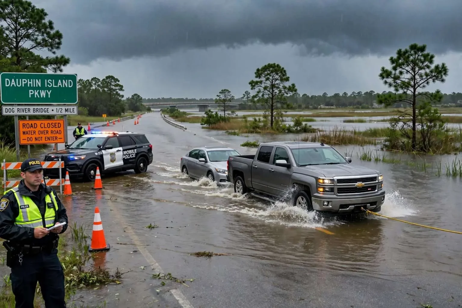
A section of Dauphin Island Parkway was underwater Sunday afternoon, June 7, 2020, with a significant amount of water covering the roadway just north of the Dog River Bridge. Mobile Police officers responded to the scene as the high water set in around 1:15 p.m. The flooding left the stretch impassable for many vehicles, though some pickup truck drivers attempted to push through — and at least one vehicle was spotted being towed through the water by another truck, a vivid illustration of what happens to motorists who gamble on a flooded road.
The scene played out on one of the most flood-prone corridors in Mobile County. Dauphin Island Parkway, known locally as DIP, runs south from the city toward the communities along the western shore of Mobile Bay and the bridge onto Dauphin Island, crossing low-lying ground where Dog River and its tributaries meet the tide. When heavy rain combines with high tide, water has nowhere to go except across the road, and the stretch just north of the Dog River Bridge has flooded repeatedly over the years, closing the route and stranding drivers who underestimated the depth.
What officers found
By the time Mobile Police arrived around 1:15 p.m., standing water had spread across the roadway north of the bridge, turning a busy southbound route into a shallow lake. Officers positioned themselves to warn approaching drivers and to discourage attempts to cross, since a flooded roadway conceals hazards that drivers cannot judge from behind the wheel: submerged pavement edges, potholes, displaced manhole covers, and currents strong enough to move a vehicle. Even water that appears shallow can lift a car’s wheels off the pavement or stall an engine in seconds.
That physics was on display in the most memorable image of the afternoon, when at least one vehicle was spotted being towed through the water by another truck. The sight of a car dragged along by a rope or chain through flooded pavement is a familiar one along the Gulf Coast after heavy rain, and it usually ends with the towed vehicle’s owner facing a repair bill for water damage that insurance may not cover. Authorities cautioned motorists against driving through standing water anywhere on the parkway, repeating the message that emergency crews deliver after every flood event: turn around, don’t drown.
Why this stretch floods
The geography explains the problem. The Dog River watershed drains a broad swath of west and central Mobile, collecting stormwater from neighborhoods, commercial corridors, and tidal creeks before emptying into Mobile Bay. Near the bridge, the parkway crosses ground that sits barely above the tide line. A heavy afternoon thunderstorm — the kind that builds over the Bay in summer and stalls over one spot — can drop several inches of rain in an hour, and if that arrival coincides with high tide, the river backs up and the roadway disappears.
June 7, 2020 fell in a spring and early summer of frequent heavy rain along the central Gulf Coast, a pattern that kept low-lying roads across Mobile and Baldwin counties wet and vulnerable. The National Weather Service office serving Mobile issues flood advisories and flash flood warnings for exactly these situations, and local residents are accustomed to the cycle: rain falls, the tide comes in, and the familiar list of roads that go underwater gets posted on neighborhood social media pages, with Dauphin Island Parkway near Dog River reliably among them.
The road to Dauphin Island
Dauphin Island Parkway is more than a local street; it is the principal approach to one of the Gulf Coast’s best-known barrier island destinations. Traffic on a summer Sunday includes beachgoers heading for the island’s public beaches, anglers towing boats to the public boat launches, and visitors to the Estuarium at the Dauphin Island Sea Lab, all funneled onto the parkway and across the Gordon Persons Bridge at the island’s eastern end. A flooded section north of the Dog River Bridge therefore doesn’t just strand nearby residents — it sends weekend traffic hunting for detours through back roads that flood nearly as easily.
Communities along the corridor live with the same flood cycle. Homes near the river are built on pilings or raised foundations, flood insurance is a standard line item in household budgets, and long-time residents can recite the tide tables that decide whether an afternoon storm will stay in the ditches or climb into the streets. For newcomers, each flood event is a lesson in the realities of driving on the northern edge of Mobile Bay.
The dangers of driving through floodwater
Safety agencies repeat the same numbers after every coastal flood because they bear repeating. A foot of moving water can carry away most passenger cars, and even still water half that deep can stall an engine or hide a washed-out shoulder. Drivers who misjudge depth frequently find their vehicles floating or dead in the middle of the flooded stretch, at which point they face the choice between climbing out into the water and waiting inside a vehicle that may keep sinking. Emergency responders in Mobile have rescued drivers from flooded roadways many times, and each rescue puts both the motorist and the rescuer at risk.
The vehicle towed through the water by another truck on Sunday was, in the scheme of things, a lucky outcome. The practice — attaching a rope or chain and dragging a stalled car to dry pavement — is a Gulf Coast tradition after floods, but it is a dangerous one: the towing vehicle strains against water resistance, the towed car can jackknife or surge, and anyone standing in the water connecting the two is exposed to currents and submerged debris. Police and safety officials would rather drivers never reach that point, which is why officers posted at flooded sections turn vehicles around before they enter the water.
How the city responds when the water rises
Flood response along Dauphin Island Parkway follows a routine that city agencies know well. Police close or warn off the flooded section, public works crews check storm drains and culverts for debris that might be holding water back, and the city monitors the tide gauge to gauge how long the water will stand. In prolonged events, barricades go up and detour signs appear, routing southbound traffic onto alternate routes. The water on a day like June 7 typically recedes within hours of the tide turning, and the road reopens — until the next storm and the next high tide arrive together.
Longer-term, the corridor has been the subject of repeated drainage studies and improvement projects, as Mobile has grappled with aging stormwater infrastructure and the steady growth of paved surfaces across the Dog River watershed. Every added parking lot and rooftop upstream sends more runoff downstream toward the same low bridge approach. City engineers and watershed groups have promoted retention ponds, drain maintenance, and living shorelines along the river as partial answers, but the fundamental geography of the parkway — a road on filled low ground beside a tidal river — ensures that flooding will remain a recurring character in the corridor’s story.
Summer storms on the central Gulf Coast
The June 7 flooding fit the classic pattern of a Mobile summer. From late May through September, the region’s afternoons routinely produce torrential thunderstorms that can drop inches of rain in under an hour, and the same tropical moisture that fuels those storms can organize into tropical systems that push storm surge up Mobile Bay. Residents plan around it: beach trips to Dauphin Island get shuffled to mornings, boaters watch the sky, and drivers on low-lying routes like the parkway know to check the radar and the tide before committing to the trip south.
Climate and weather watchers have noted that the heaviest downpours along the Gulf Coast have grown more intense in recent decades, straining drainage systems designed decades ago and turning once-rare street flooding into a more frequent occurrence. Cities across the coast, Mobile among them, have been updating stormwater plans and seeking federal funding for resilience projects. For the neighborhoods along Dog River, though, the practical arithmetic is unchanged from years past: heavy rain plus high tide equals water on the parkway, and wise drivers wait it out.
A reminder for drivers
The Sunday afternoon scene — police lights at the water’s edge, stalled vehicles, a car towed through the flood by a determined pickup driver — ended the way such scenes usually do: with the road reopening after the water drained and a handful of drivers facing flooded engines and tow bills. It also ended, notably, without reports of serious injuries, which is the outcome police work to secure every time they post officers at a flooded roadway. The caution from authorities was simple and standard: never drive through standing water on the parkway, because the depth is impossible to judge and the road beneath it may be compromised.
For residents of Mobile’s southern neighborhoods and weekend travelers bound for Dauphin Island, the June 7 flooding was a familiar chapter in the life of the corridor, and a preview of the summers to come. The water will rise again with the next big storm and the next high tide, and the advice from authorities will be the same. On a road that runs between a tidal river and the open bay, the surest route to the beach is the one that waits for the water to go down.