Dredge, Pipeline and Support Vessels: Boaters Told to Slow Down Near Fowl River Through November
Dredging for the Salt Aire Shoreline Restoration Project is underway near Fowl River through Nov. 30, with a 16-inch submerged pipeline, a dredge and support vessels in the water. Mobile County is asking boaters to keep their distance and follow temporary markers.
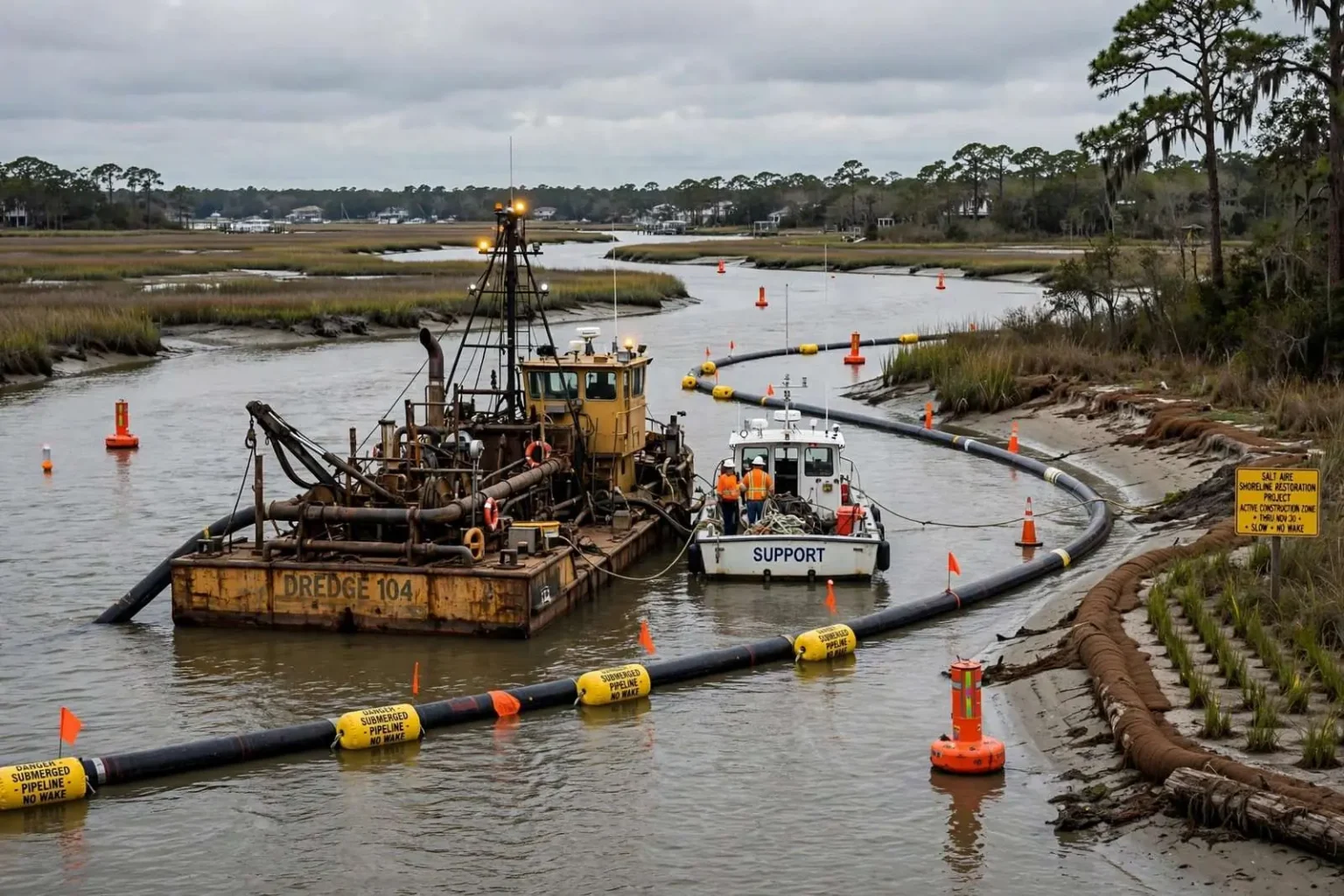
MOBILE COUNTY, Ala. — Boaters traveling near Fowl River are being asked to use extra caution through the end of November, with dredging equipment, a submerged pipeline and support vessels operating in the area.
Mobile County issued the advisory in connection with the Salt Aire Shoreline Restoration Project, which is rebuilding marsh along the shoreline. The work puts heavy marine equipment into a waterway that serves a mix of recreational fishermen, crabbers, pleasure boaters and waterfront residents, and the county wants every vessel operator aware of what is in the water and where.
Fowl River winds through southern Mobile County before emptying into Mobile Bay, and its shoreline communities depend on the waterway for both livelihood and recreation. An active construction zone in the river changes daily routines for everyone who launches a boat nearby, which is why the county has spread the word through posted notices, marine channels and local outreach well ahead of the heaviest construction activity.
What is in the water
Dredging operations are underway through Nov. 30. Crews are working with a 16-inch submerged pipeline, a dredge and support vessels stationed in the work area — a combination that narrows the navigable channel and demands slower, more deliberate transits from every boat passing through.
All equipment is lighted in accordance with U.S. Coast Guard regulations, and temporary navigation markers and warning signs have been placed to define the work zone. The lighting makes the dredge and vessels visible at dawn, dusk and night, when a boater running late from a fishing spot is most likely to encounter the work area unexpectedly.
A submerged pipeline is a particular hazard because it is not visible from the surface, which is why the marker placement matters as much as the lighting on the vessels themselves. A pipeline strung across or along a waterway sits just below the waterline — out of sight of a running boat — and a propeller that strikes one can be destroyed in seconds, leaving a vessel disabled in the channel and its occupants facing a tow.
The dredge itself operates slowly, moving in stages as it pulls sediment from the bottom, and support vessels shuttle between the dredge and shore. Boaters should assume the equipment’s positions change day to day and treat the marked zone as an active construction site rather than a fixed obstruction with a known location.
What boaters are asked to do
The county’s advisory lays out three basic rules for anyone transiting the area:
Maintain a safe distance from the dredge, pipeline and vessels. The marked zone exists to keep boat traffic out of the path of equipment that cannot maneuver quickly, and the margin between a safe pass and a dangerous one narrows with speed.
Follow all posted navigational aids and temporary markers. The temporary markers override habitual routes: a channel line that boaters have run for years may be rerouted through the work zone, and the buoys and signs in place during the project are the authoritative guide.
Use extra caution when transiting through the work area. That means reduced speed, a proper lookout and patience — particularly on weekends and during afternoon runs, when recreational traffic is heaviest and the chance of multiple vessels converging on the narrow passage is highest.
Operators who keep to those rules protect more than themselves. A collision with the dredge or pipeline halts construction, damages public project equipment and could leave a boater liable for the damage — costs that ripple back to the restoration project’s timeline and budget.
Why the work is happening
The Salt Aire Shoreline Restoration Project is restoring marsh habitat along Fowl River — one of a number of shoreline and marsh restoration efforts underway across coastal Alabama, where habitat loss and shoreline retreat have been documented across the Mississippi Sound and Mobile Bay systems.
The science behind the loss is well established. Wave energy from boat wakes and storms, rising water levels and the disappearance of the natural buffers that once absorbed wave action have eaten away at shorelines throughout the bay system. Marsh edge erodes first, and as the marsh goes, so goes the habitat it provides — the nursery grounds for shrimp, crab and finfish, the foraging areas for wading birds, and the natural wall that protects waterfront property from storm surge.
Marsh restoration projects typically use dredged sediment to rebuild elevation, then plant native marsh grasses whose root systems stabilize the shoreline over time. The approach turns the dredging itself into part of the solution: sediment pulled from navigation channels or the river bottom — material that would otherwise be handled as waste — becomes the building block of a new marsh platform, graded to the right elevation and planted with the grasses that anchor it.
Once established, a restored marsh pays dividends that grow with each season. The root mats trap sediment, the vegetation slows wave energy before it reaches the bank, and the habitat supports the fisheries that recreational and commercial anglers depend on. Restoration practitioners along the Gulf Coast have refined the technique over dozens of projects, and the marshes built in earlier efforts along Mobile Bay now function as self-sustaining habitat.
The tradeoff of a construction season
The tradeoff is a construction season that puts heavy equipment into a waterway used heavily by recreational and commercial boaters alike. There is no way to rebuild a shoreline marsh without working in the water, and the work window — through Nov. 30 — was chosen to fit the project’s schedule around conditions, permitting and the ecological calendar.
For the river’s regular users, the intrusion is temporary but real. Boat ramps and waterfront access points near the work area see construction traffic, fishing holes inside the zone are temporarily off-limits, and the transit past the dredge takes longer than the usual run down the river. The county’s request — caution, distance and patience — is the price of the project’s benefits.
The work window runs through Nov. 30. After that, the equipment leaves, the markers come down and the river returns to its ordinary patterns — with a new marsh taking root along the shoreline where the dredge spent the season.
Restoration across coastal Alabama
The Salt Aire project belongs to a broader, ongoing effort to hold and rebuild the coastal margins of Mobile Bay and the Mississippi Sound. Shoreline restoration projects have been completed or advanced in recent years at sites across the region — along bay-front parks, river mouths, causeway shorelines and private waterfronts — funded through a mix of federal restoration programs, state coastal funds and local partnerships.
The shared goal is measurable: slow shoreline retreat, rebuild the habitat base that supports the bay’s fisheries, and armor the coast’s edges with living systems rather than hard structures alone. Living shorelines like the marsh at Salt Aire perform better than bulkheads in many settings — they absorb wave energy, adapt to changing water levels and grow more effective as the plantings mature.
For Fowl River’s communities, the project means a stronger shoreline heading into future storm seasons, better fish and wildlife habitat in the river’s shallows, and a demonstration of the restoration techniques now spreading across coastal Alabama. For boaters, it means a marked work zone and a slower transit through November — a small price for a shoreline that will still be there, and thriving, long after the dredge is gone.
Marsh country on Mobile Bay
Fowl River’s marshes are part of a productive belt of wetlands that fringes Mobile Bay and the rivers feeding it. These tidal margins rank among the most biologically productive habitats on the Gulf Coast: blue crabs spend their early lives in the shallows, shrimp move through on their way offshore, and the marsh edge shelters the small forage fish that feed game species from speckled trout to redfish. When marsh erodes, that productivity drains away with the land.
The losses across the bay system have accumulated over decades. Shoreline maps comparing historical surveys with modern imagery show measurable retreat along unprotected banks, and the trend accelerates during active hurricane seasons, when a single storm surge can strip years of marsh edge in a matter of hours. Salt spray from surge events also kills shoreline trees and vegetation well inland, weakening the buffers that remain.
Restoration practitioners count the Salt Aire type of project among the most cost-effective answers. A bulkhead protects one property and often worsens erosion on its neighbors by reflecting wave energy; a marsh protects the shore while absorbing that energy, supporting fisheries and improving water quality as it grows. The restoration economy built around those projects — dredging contractors, native plant nurseries, monitoring scientists — has become part of coastal Alabama’s working landscape.
Reading the markers: a boater’s checklist
Boaters planning a Fowl River run during the work window can spare themselves trouble with a short checklist. Check the latest advisory before launching, since the equipment’s position within the work zone changes as the dredge advances. On the water, keep the marked channel between the buoys and resist the shortcut instinct — the submerged pipeline’s location is exactly where a straight-line route would tempt a boater to cut.
Slow down before entering the zone rather than inside it, keep passengers clear of the bow area, and watch for support vessels crossing between the dredge and shore on unpredictable headings. At night, give the lighted equipment extra distance: the lights mark where the hazard is, not the full extent of the pipeline below.
Anglers who normally fish the affected stretch should plan alternates for the season. The river offers plenty of water outside the work zone, and the marsh habitat being built nearby will, once established, only improve the fishing that the construction season briefly disrupts.
After the dredge leaves
When the Nov. 30 deadline passes, the visible work ends and the invisible work begins. The newly graded marsh platform needs time for its plantings to take hold, and monitoring typically follows restoration projects through successive growing seasons to confirm that the grasses survive, spread and begin doing the structural work of a mature marsh.
The payoff compounds slowly. Within a few years, a successful project shows a shoreline that no longer retreats measurably during ordinary weather; over decades, it shows a marsh that traps its own sediment, builds elevation against rising water and shelters the next generation of the bay’s fish and wildlife. That is the standard the Salt Aire project will be measured against — long after the last boater has forgotten the November detour.
Until then, the county’s advisory stands: slow down, stay clear of the dredge, the pipeline and the support vessels, follow the temporary markers, and give the crews building Fowl River’s new shoreline the room to finish the job.