Gulf Coast meteorologists gather for severe weather round table
Gulf Coast meteorologists including Mobile's Ed Bloodsworth discussed the weekend severe weather threat in a round table.
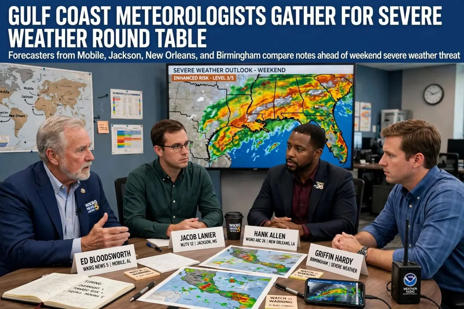
Local meteorologists from across the Gulf Coast and Southeast compared notes this week on the severe weather threat expected to hit the region this weekend, in a round-table discussion that pulled together forecasters whose viewing areas together span much of the northern Gulf Coast and interior Southeast. The conversation covered how the storm system was expected to evolve, which hazards looked most concerning in each market, and what residents should be doing before the first warning is issued.
WKRG’s Ed Bloodsworth, the veteran Mobile-based forecaster whose station serves the central Gulf Coast from the Alabama beaches into northwest Florida, was joined by Jacob Lanier of WJTV in Jackson, Mississippi, Hank Allen of WGNO in New Orleans, and Griffin Hardy in Birmingham. The four covered a stretch of real estate that severe weather systems routinely cross in a single day — storms that form in Mississippi move through Alabama and on toward the coast and Georgia — which is precisely why forecasters in those markets talk to one another when a significant system approaches.
The group reviewed the threats looming along the Southeast and Gulf Coast and shared what viewers should watch for as storms approach. That kind of cross-market comparison serves a practical purpose beyond professional courtesy: each meteorologist sees the same storm system from a different position along its path, and the conditions developing in one market become the verification — or the correction — for the forecast in the next one down the line.
Why the Gulf Coast watches severe weather so closely
The Gulf Coast and Southeast live with a severe weather profile unlike anywhere else in the country. The region gets two pronounced severe weather seasons — the spring season familiar to the Plains states, and a fall and winter season that most of the country never thinks about, when strong storm systems riding the jet stream meet warm, humid Gulf air. Tornadoes in this region are frequently rain-wrapped, embedded in fast-moving squall lines, and — most dangerously — they occur at night and in the overnight hours at rates higher than almost anywhere else, when families are asleep and warnings are hardest to act on.
Mobile Bay and the coastal counties add their own wrinkles. Storms arriving off the Gulf carry tropical moisture that can flood streets quickly, and the region’s history — from the April 2011 outbreak that devastated parts of Alabama to countless lesser events — has made severe weather preparedness a year-round habit for schools, churches, and local governments. Broadcast meteorologists in Mobile, Birmingham, New Orleans, and Jackson are, in a real sense, the front line of that preparedness culture: they are the voices residents hear when a warning is issued and the ones whose judgment decides how urgently a threat is presented.
That is the context in which the round table took place. Forecasters comparing notes on a weekend threat are doing the coordination work that makes the region’s warning system function — aligning on timing, emphasizing the hazards each stretch of the path will face, and spreading the same core advice across four viewing areas before the storms arrive.
What the forecasters told viewers to watch for
While each market faces its own specific threats from a given system, the advice the meteorologists shared has the common core that Gulf Coast severe weather preparedness always does. Watch the timing, because overnight storms demand a plan that works while you are asleep — a way to be woken that does not depend on hearing a siren or glancing at a phone. Know where you would go in your home: the lowest floor, the most interior room, away from windows. And keep basic supplies where you can reach them, since storms that produce tornadoes also produce the power outages and blocked roads that complicate everything afterward.
The forecasters’ markets themselves illustrate the geography of a Gulf storm system. Jackson, covered by WJTV, is typically among the first to face a storm system as it moves across Mississippi; Birmingham, where Griffin Hardy forecasts, often sits under the threat as storms mature over central Alabama; Mobile and the coastal counties, WKRG’s home territory, face the system’s passage toward the Gulf and the possibility of squall lines arriving off the water; and New Orleans, WGNO’s market, deals with the same systems as they exit the region or reform along the coast. A discussion among the four is effectively a timeline of the storm’s journey, told by the people responsible for each segment of it.
The round-table format has become a familiar one for Southern TV meteorologists, who regularly appear on one another’s broadcasts and share radar data when major systems approach. The collegiality is born of hard experience: the outbreaks that have shaped the region’s weather culture — most memorably the April 2011 tornado super outbreak in Alabama — were events that no single station could cover alone, and the relationships built across markets in those events persist in the quieter coordination that precedes every significant threat since.
Multiple ways to receive warnings
For the latest severe weather updates, residents can follow local forecasts and make sure they have multiple ways to receive warnings — the advice the meteorologists emphasized and the single most repeated piece of severe weather guidance in the Southeast. The reasoning is simple: no single warning method is reliable in every circumstance. Tornado sirens are meant for people outdoors and cannot be counted on indoors, especially overnight. Cell service and power can fail in a storm. A warning that arrives on a phone set to silent does no good to a sleeping household.
The standard toolkit includes a NOAA Weather Radio with battery backup and tone alert, which sounds an alarm when the National Weather Service issues a warning for the listener’s county regardless of what is on television; the Wireless Emergency Alerts that push tornado warnings to modern cell phones automatically; local broadcast television and radio, which provide the live, local context that automated alerts cannot; and phone apps tied to local stations, which can follow a storm’s track in real time. Meteorologists recommend at least two of those channels, precisely so a failure in one does not leave a family without the warning that matters.
Overnight threats raise the stakes on that advice. A tornado warning issued at 2 a.m. reaches a household only if something in the house is loud enough to wake them — a weather radio’s tone alarm, a phone’s emergency alert cutting through silent mode, or a family member watching the broadcast. That is why forecasters across the Gulf Coast spend as much airtime on how warnings are received as on the storms themselves, and why the round-table discussion of a weekend threat is as much a preparedness reminder as a weather report.
Staying ahead of the storm
As the weekend approached, the four meteorologists’ shared message came down to the essentials that Gulf Coast residents have heard before every significant threat: pay attention to the forecast as it sharpens, know the difference between a watch and a warning, have a shelter plan that works at any hour, and keep devices charged. Watches mean conditions are favorable for severe storms and are the time to make sure plans are in place; warnings mean a storm has been detected and it is time to act immediately.
Local stations in each market — WKRG in Mobile, WJTV in Jackson, WGNO in New Orleans, and the Birmingham outlets Griffin Hardy serves — planned continuing coverage as the system developed, with updated forecasts as the storm’s timing and track came into focus. For residents across the Gulf Coast and Southeast, the collective advice of the forecasters who cover the region boils down to this: the storms are coming on a schedule the atmosphere has largely set, the warnings will be there for those set up to receive them, and the families who treat preparedness as routine are the ones who weather these events best.
The meteorologists behind the forecasts
The participants in the discussion represent decades of combined experience with Southern severe weather. Ed Bloodsworth has been a fixture of WKRG’s weather coverage in Mobile, guiding the central Gulf Coast through hurricane seasons and tornado outbreaks alike from the station that has long anchored News 5’s coverage of the Alabama and northwest Florida coast. Jacob Lanier forecasts for the Jackson, Mississippi market at WJTV, a city that sits squarely in the path of many of the storm systems that later reach Alabama. Hank Allen covers New Orleans for WGNO, a market that deals with the full range of Gulf hazards, from hurricanes to the tornado-producing squall lines that sweep the metro area. Griffin Hardy forecasts in Birmingham, at the heart of Alabama’s tornado alley, where the state’s most devastating tornado tracks have passed.
When forecasters with that coverage map compare notes on a single weekend threat, the result is a picture no one station could assemble alone: the same system seen from Jackson to New Orleans to Mobile to Birmingham, with each forecaster contributing local knowledge of terrain, drainage, vulnerable communities, and the timing quirks that distinguish one county from the next. That shared picture is what allows warnings to make sense across market boundaries when a storm line crosses them in the middle of the night.
The discussion also reflects how weather communication has changed in the social media era. Round tables among stations in different markets are now broadcast live and clipped for online audiences, meaning a viewer in coastal Alabama can hear directly from the forecaster whose market the storm crossed twelve hours earlier. For a region where storms move fast and overnight, that transparency — seeing the forecast verified or adjusted in real time across state lines — builds the kind of trust that becomes critical when a forecaster says the words that interrupt regular programming.
For now, the forecasters’ collective attention turns to the weekend, and their advice to the region stands: follow the local forecasts, keep multiple ways to receive warnings within reach, and treat every watch as the cue to put the plan in motion. The storms will do what the atmosphere decides; the round table’s purpose was to make sure the people in their path are ready when they arrive.