Large Brush Fire Sends Smoke Plume Over Mobile Bay Visible From Daphne
A large brush fire near Highway 188 in Coden drew multiple fire departments and sent smoke visible from Daphne across Mobile Bay.
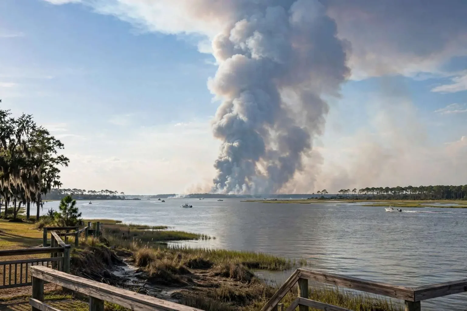
A large brush fire in southern Mobile County sent a towering plume of smoke into the sky Thursday afternoon, visible clear across Mobile Bay in Daphne. Several fire departments responded to the fire in a wooded area west of Dauphin Island Parkway near Highway 188 in Coden. Despite the size of the smoke column, the Alabama Forestry Commission said the blaze was actually a controlled burn. Officials did not report any injuries or damage to structures.
The sight drew attention all over the eastern shore. A plume heavy enough to be seen from Daphne, across the open water of Mobile Bay, is a substantial column of smoke, and many residents who spotted it assumed the worst. Fire departments from the surrounding communities responded to the scene near the Coden community, at the southern end of Mobile County, and found a prescribed fire being conducted in the wooded land west of the highway.
That distinction, an uncontrolled wildfire versus a controlled burn, changed the story from emergency to routine, but it did not happen automatically. It took responders on the scene and confirmation from the Alabama Forestry Commission, the state agency that regulates and often conducts prescribed burns, to establish that the fire was intentional, contained, and being managed. Once that was clear, the response shifted to monitoring rather than fighting, and no injuries or structural damage were reported.
Where the fire was
Coden sits at the southern edge of Mobile County, a small waterfront community on the bay side of the peninsula that runs down toward Dauphin Island. The area is a mix of marsh edge, pine woods, and scattered homes, reached from Mobile by Dauphin Island Parkway, also known as Highway 193, with Highway 188 branching west toward Grand Bay through the rural country inland from the shore.
The fire burned in wooded terrain west of Dauphin Island Parkway near Highway 188, in exactly the kind of landscape where prescribed fire is routinely used in south Alabama. Pine timberland dominates the region’s rural stretches, and much of it is managed for timber production, hunting, and wildlife habitat, all of which depend on periodic fire to clear undergrowth and maintain the ecosystem the longleaf and slash pine forests evolved with.
Geography explains the plume’s visibility. Mobile Bay runs roughly thirty miles north to south, and Daphne sits directly across the water from the Mobile area’s eastern shore communities. The bay acts as an open sight line, so a smoke column rising over the Coden area, near the bay’s southern end, stands out against the sky for anyone looking south from the eastern shore. Weather on the day, with the column rising vertically, made the fire visible at a distance that a low, drifting haze would not have been.
Controlled burns in south Alabama
The Alabama Forestry Commission’s identification of the blaze as a controlled burn places it in a long-standing and highly regulated practice. Prescribed fire is used across the Gulf South to reduce the buildup of brush and dead material that would otherwise fuel wildfires, to prepare land for timber regeneration, and to maintain habitat for the region’s fire-adapted plants and wildlife. Landowners conduct these burns under permits, in defined weather conditions, and with crews standing by.
A properly conducted prescribed burn is planned like a construction project. Crews establish fire lines around the area to be burned, check wind speed and direction and humidity, notify the Forestry Commission and local fire departments, and ignite the area in a controlled pattern so the fire burns inward at a manageable intensity. Smoke management is part of the plan, but a large burn in still afternoon air can still produce a column visible for many miles, as Coden and Daphne saw on this Thursday.
The practice occasionally generates alarm exactly because it looks like a wildfire from a distance, and fire departments know the pattern. Calls come in from worried residents, units respond, and the first task on scene is to confirm whether the fire is authorized. In this case several departments made the trip to the wooded area west of the parkway before the situation was confirmed as a managed burn.
The response and what it looked like
The sight of a towering smoke column triggered the standard Gulf Coast response: residents called it in, and fire departments from communities across southern Mobile County rolled toward the scene near Coden. Several departments responded, which is normal for a rural fire of apparent size, since mutual aid agreements among small volunteer and combination departments mean that no one unit handles a large incident alone.
Once crews reached the wooded area west of Dauphin Island Parkway and the burn was identified as controlled, the emergency posture relaxed. The Forestry Commission’s confirmation is the deciding voice in these situations, since the agency keeps the registry of permitted burns and can verify whether the fire at a given location matches one. With the burn verified, responding units cleared or stood by, and the burn crew continued its work as planned.
The outcome, no injuries and no damage to structures, is the ordinary conclusion of a properly managed prescribed fire. The smoke was real and dramatic, but the fire itself stayed inside its lines, did what land managers intended it to do, and ended without harm to people or property. What residents across the bay saw was the largest, most alarming part of the process, the column of smoke, and not the careful work taking place on the ground beneath it.
What smoke across the bay means for residents
For people in Daphne and the eastern shore communities, the episode was a reminder of how far smoke travels and how quickly it draws attention. Under the right wind and atmospheric conditions, smoke from a burn in southern Mobile County can be seen, and sometimes smelled, across the bay and well into Baldwin County. Health officials generally advise that smoke haze is most concerning for people with asthma or other respiratory conditions, the elderly, and small children, who should stay indoors when smoke is thick nearby.
For drivers, the more practical danger is smoke crossing a roadway. Columns from large burns can drift across Dauphin Island Parkway, Highway 188, and the causeway areas, dropping visibility suddenly, and the advice in those situations is to slow down, turn on headlights, and if visibility collapses, pull safely off the road and wait. Fire managers time burns to keep smoke off major roads, but wind changes can outpace the plan.
Residents who spot a large smoke column should report it rather than assume it is authorized. Fire departments would rather confirm a controlled burn than discover a wildfire late, and the distinction is not always visible from a distance. Information about permitted burns is available through the Alabama Forestry Commission, which tracks burn permits and can usually confirm quickly whether a fire in a given area is registered.
Living with fire on the landscape
Fire is a permanent part of south Alabama’s environment, and the region’s pine woods are healthier because of burns, not despite them. Without periodic fire, undergrowth accumulates until the eventual wildfire, sparked by lightning, equipment, or an unattended flame, burns hotter, moves faster, and threatens homes that a managed understory would have protected. Foresters and wildlife biologists across the Gulf Coast argue that the question is not whether the land burns but whether it burns on purpose or by accident.
The Coden plume offered a visible lesson in that reality. The same landscape, the same afternoon weather, and the same column of smoke could have described a wildfire, and the difference was planning, permits, and crews with fire lines. Communities that understand prescribed fire respond to it with fewer false alarms and better cooperation, and fire departments in the rural parts of Mobile County have invested in exactly that understanding over the years.
Thursday’s events ended the way managers intended: a large, visible, thoroughly reported fire that turned out to be a deliberate tool of land management, with no injuries and no damaged structures, and a smoke column that for a few hours connected two sides of Mobile Bay in shared attention to the fire-prone country at the county’s southern end.
How the community learned what was happening
The gap between seeing a huge smoke column and knowing what it was lasted only as long as it took responders to reach the scene and the Forestry Commission to confirm the burn, but in that interval the story moved on its own. Residents photographed the column from Daphne, from the bay bridges, and from points around Mobile, and the sheer size of the plume made it the talk of the afternoon until word came back that the fire was authorized and under control.
That sequence is now a familiar one along the Gulf Coast, where prescribed burns are frequent and social media spreads images faster than any official announcement. Fire communicators respond by asking residents to check burn permits before sharing alarm, and by confirming controlled burns as quickly as possible so the public record catches up with the pictures. In this case the confirmation came the same afternoon, closing out what could otherwise have been a long evening of rumor.
The departments that responded to the wooded area west of Dauphin Island Parkway did the community a service even though the fire was authorized. Verifying a burn on the ground is part of how the system stays honest: a permit holder who burns outside the planned area or in unsafe conditions is caught because crews check. Thursday’s burn checked out, the plume rose and drifted, and by evening the sky over the southern bay was simply the sky again.