Waterspout Spotted Over Mobile Bay
A waterspout was spotted spinning over Mobile Bay on Monday morning, captured on camera by a local viewer.
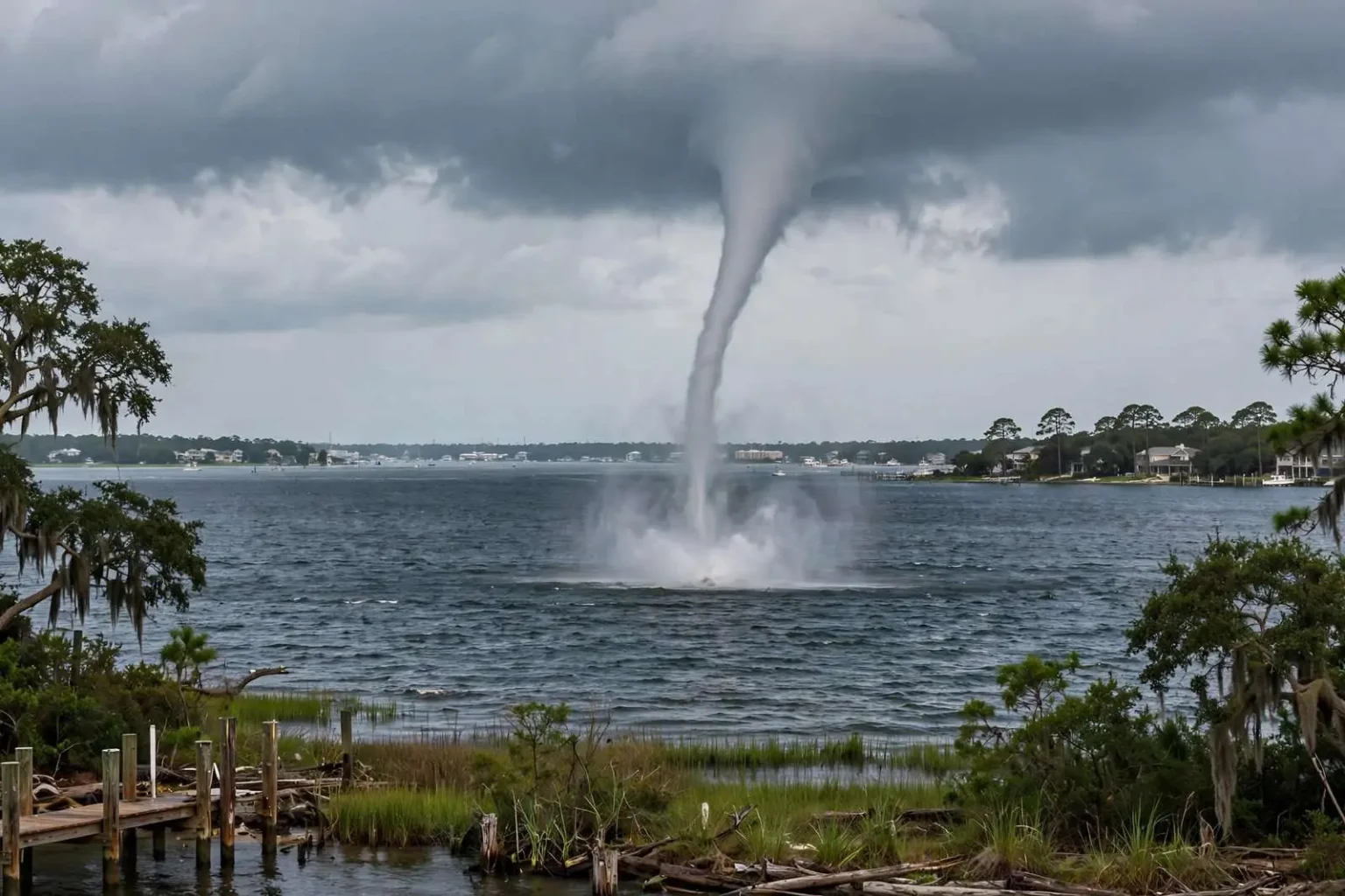
A waterspout was spotted spinning over Mobile Bay on Monday morning. Viewer Carlos Amaya shared images of the weather phenomenon with the newsroom. Waterspouts are rotating columns of air that form over water and are most common during the warm months along the Gulf Coast. While they can look dramatic, waterspouts often dissipate quickly once they move onshore.
Sightings like Monday’s are a familiar part of life around Mobile Bay, where warm water, humid air and shifting summer weather patterns regularly combine to spin up short-lived funnels over the water. The bay’s wide, shallow expanse heats quickly under the morning sun, and that warmth rising off the surface can set the atmosphere rotating just above the waterline. From shore, residents in communities bordering the bay, from Spanish Fort and Daphne on the Eastern Shore to Mobile and the communities along the western shoreline, occasionally catch the spectacles from their homes, boats and fishing piers.
The images shared with the newsroom show the kind of narrow, twisting column that typically forms over the bay in the warm months. Waterspouts of this kind are usually tied to rapidly growing clouds rather than organized severe storms, and they tend to last only minutes before collapsing. Because they can appear suddenly and move with the prevailing breeze, boaters and beachgoers are advised to keep an eye on the sky whenever a dark, cloud-based funnel appears anywhere over the water.
What a Waterspout Actually Is
Meteorologists distinguish between two main types of waterspouts. Fair-weather waterspouts, the far more common variety on Mobile Bay, develop from the water surface upward beneath a growing cumulus cloud, usually in light wind conditions. They form as warm, humid air near the water rises and begins to spin, tightening into a visible column that connects the cloud base to the bay. These spouts generally move slowly, at speeds of just a few knots, and rarely live longer than fifteen or twenty minutes.
Tornadic waterspouts, by contrast, are true tornadoes that either form over the water or move from land onto it, and they are associated with strong thunderstorms, large hail and damaging winds. Forecasters with the National Weather Service office that covers the central Gulf Coast treat those very differently, issuing warnings and urging residents to take shelter. Monday’s sighting, described as a spinning column over open water during the morning, fits the fair-weather pattern that area residents most often photograph from the shoreline.
Despite their gentler reputation, fair-weather waterspouts are still hazards on the water. A rotating column capable of lifting spray and debris can capsize small boats, damage docks and injure anyone caught beneath it. Emergency managers along the Gulf Coast regularly repeat the same advice to mariners: if a waterspout is spotted nearby, do not try to approach or photograph it from a boat, and steer at a right angle away from its path rather than trying to outrun it.
Why Mobile Bay Sees So Many
The central Gulf Coast is one of the more active waterspout regions in the country, and Mobile Bay’s geography helps explain why. The bay stretches roughly thirty miles from its mouth at the Gulf to the head of the bay near the causeway, with depths that are generally shallow for its size. Shallow water warms faster than deep water, and that heat feeds the rising air currents that begin the rotation process. During the warm months, when water temperatures in the bay climb and afternoon sea breezes push across the coastline, conditions for short-lived spin-ups appear on a near-daily basis, even when no rain is falling.
The region’s summer weather pattern, with scattered pulse storms building over land in the afternoon and drifting toward the coast, also contributes. Waterspouts can form along the leading edges of these clouds as they move out over the bay, and multiple spouts have been photographed at once during active stretches of weather. Local photographers and fishing captains have long treated the phenomenon as a seasonal feature of life on the bay, swapping images and reports whenever a funnel appears near the shipping channel or the barrier islands at the bay’s mouth.
When a Spout Comes Ashore
Although most waterspouts weaken and dissolve over open water, some do reach the shoreline, and the transition matters for coastal neighborhoods. When the circulation crosses the beach, it becomes a tornado by definition, and even a weakening one can snap tree limbs, tear shingles from roofs and scatter unsecured yard furniture. National Weather Service guidance for anyone on land who sees a waterspout approaching is the same as for any tornado: move inland, put as many walls as possible between you and the funnel, and stay away from windows until the rotation passes.
Boaters on the bay have a different set of priorities. The recommended maneuver is to move away from the spout’s track at a perpendicular angle, because the columns generally drift slowly with the wind and change direction less often than boaters expect. The U.S. Coast Guard and marine patrol units in Baldwin and Mobile counties echo the warnings during the warm months, noting that jet skis and small fishing boats are the vessels most often caught near developing spouts, simply because they operate closest to the surface conditions that produce them.
How Forecasters Track Bay Weather
The National Weather Service forecast office responsible for Mobile and the surrounding Gulf Coast monitors waterspout conditions through radar, satellite imagery and reports from spotters along the shoreline. Radar can sometimes show the tight rotation associated with a stronger waterspout or a tornado moving over the bay, but fair-weather spouts are frequently too weak and too brief to appear on radar at all, which is why reports from residents, boaters and camera networks around the bay are so valuable to forecasters. Images and observations submitted by members of the public, like those shared with the newsroom on Monday, help confirm what the atmosphere was doing and when.
Marine forecasts issued for Mobile Bay and the adjacent coastal waters routinely flag the potential for waterspouts during the warm season. Boaters are encouraged to check the marine forecast before heading out and to monitor NOAA Weather Radio while on the water, since conditions that look calm at the boat ramp can change within an hour as clouds build. Charter captains and commercial fishermen working the bay tend to develop a practiced eye for the dark, ragged cloud bases and patchy sea spray marks on the water that signal a developing rotation.
A Familiar Seasonal Sight for Bay Communities
Longtime residents of the Mobile Bay area can usually recall at least one memorable spout from years past, whether seen from the Fairhope pier, the Causeway restaurants at the head of the bay, or the beaches near the bay’s mouth. Photographs of spouts with the city skyline in the background circulate widely on social media whenever conditions are right, and local meteorologists often use the moment to remind followers of the difference between a safe, distant viewing experience and a dangerous one on the water.
Weather watchers in the region contribute observations through official spotter programs as well. Trained storm spotters in Mobile and Baldwin counties report funnel sightings to the National Weather Service, which uses the reports to verify radar indications and to decide whether warnings are needed for communities downwind. The network of eyes along the shoreline, combined with the growing number of shoreline cameras and dock-side webcams, has made documenting bay waterspouts far easier than it was a generation ago.
Monday morning’s spout, captured and shared by a local viewer, follows that familiar pattern: a striking, short-lived funnel over the water, gone before conditions turned dangerous. As long as the warm months continue along the Gulf Coast, residents can expect more of these rotating columns to form over the bay. The standing advice remains unchanged, enjoy the view from shore, keep a safe distance on the water, and remember that any waterspout that reaches the beach should be treated as a tornado until the rotation clearly dies out.
Safety Reminders for the Rest of the Season
Emergency management offices in both counties that ring the bay encourage families and businesses along the waterfront to keep the basics in mind for the remainder of spout season. Small boats should carry life jackets that are actually worn, not just stowed, when weather is building. Beach umbrellas, canopies and lightweight furniture near the shoreline should be secured when dark clouds gather, since the outflow winds around a collapsing spout or storm can scatter them. Anyone who captures images of a spout is welcome to share them with local newsrooms, which helps document the phenomenon, but photographers on land should keep well back from the waterline and never position themselves in the funnel’s path.