ALDOT Unveils New Bridge Animation as Mobile River Crossing Hearings Begin
ALDOT released a new animation of the proposed I-10 Mobile River Bridge ahead of public hearings this week in Spanish Fort and Mobile, where residents can review the project's environmental study and submit formal comments.
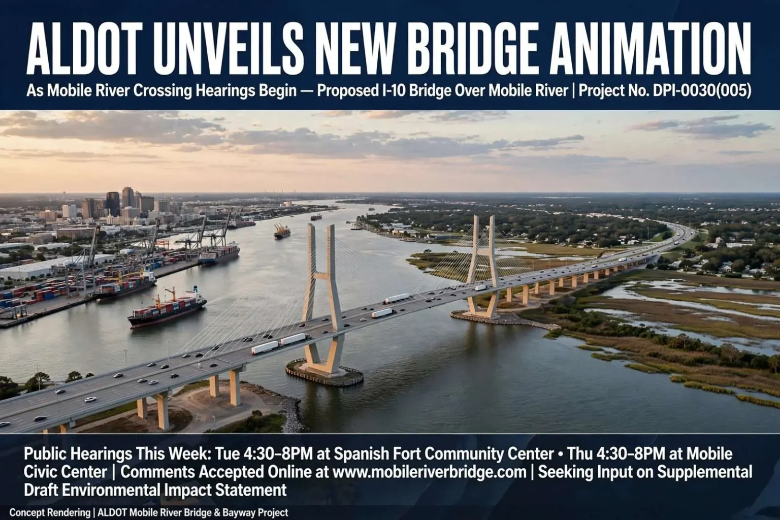
The Alabama Department of Transportation has released a new animation and set of graphics depicting the proposed Interstate 10 bridge over the Mobile River, timed to coincide with a pair of public hearings this week on the long-discussed project. The hearings, one in Spanish Fort and one in Mobile, give residents on both sides of the bay a chance to review the Supplemental Draft Environmental Impact Statement for the project, formally listed as Project No. DPI-0030(005), I-10 Mobile River Bridge and Bayway, covering both Mobile and Baldwin counties.
State transportation officials say the project is meant to address a chronic bottleneck on I-10 by adding capacity to handle current and projected traffic volumes. The plan is also intended to create a more direct route for trucks and other vehicles carrying hazardous materials, while limiting the project’s footprint on Mobile’s working waterfront and maritime industry.
The bottleneck needs little introduction for anyone who drives it. Interstate 10 is the only interstate crossing of Mobile Bay, carrying coast-to-coast traffic between Florida and the western Gulf through a tunnel beneath the Mobile River that was engineered for a city and a traffic load that no longer exist. Every hurricane evacuation on the central Gulf Coast funnels through the same choke point, and the region’s growth on both sides of the bay has multiplied the crossings the tunnel must absorb.
At each open house, attendees will be able to review exhibits and the supplemental environmental study, hear from ALDOT staff about how the project has evolved, and submit formal comments that will be folded into the eventual Final Environmental Impact Statement.
Where and when
The first hearing is scheduled for Tuesday from 4:30 to 8 p.m. at the Spanish Fort Community Center, located at 7361 Spanish Fort Blvd. A second, identical session follows Thursday from 4:30 to 8 p.m. at the Mobile Civic Center, 401 Civic Center Drive. Anyone driving to the Mobile Civic Center hearing should let parking attendants know they are there for the ALDOT meeting in order to receive free parking.
Holding one hearing on each side of the bay was a deliberate choice. The project’s impacts and its politics both split along the water: Baldwin County’s Eastern Shore communities absorb the eastbound congestion and the interchange changes, while Mobile’s downtown neighborhoods sit nearest the bridge’s approaches, the port’s operations and the historic districts that would live beneath the new span’s shadow. Residents on either side have distinct questions, and a single hearing could never have held them both.
ALDOT plans to present the same material at both locations, with a formal presentation beginning at 5:30 p.m. each night. Outside of the presentation, the format is an open house, allowing residents to walk through project maps, engineering exhibits and the draft environmental study at their own pace and to ask questions of ALDOT representatives throughout the evening.
The open-house format is the standard structure for major federal-aid highway environmental reviews, and it serves two audiences at once. Residents who want details about alignment, noise or wetlands can interrogate engineers one on one; residents who want their opposition or support on the record can wait for the formal forum. The two-track design keeps the room moving while guaranteeing that everyone’s voice reaches the administrative record that federal reviewers must legally consider.
Residents who want their comments entered into the official record during the formal public forum portion of each meeting must sign in at the registration table when they arrive. Each speaker will be limited to two minutes, and all verbal comments will be recorded and added to the public record alongside any written submissions.
How to comment
Those who cannot attend in person, or who prefer to submit comments another way, have several options. Comment forms will be available at both hearings, but residents can also submit comments online at www.mobileriverbridge.com, by email to [email protected], by fax to (251) 473-3624, or by mail. Mailed comments must be received by 5 p.m. on May 23 and should be addressed to Matt Ericksen, P.E., with the ALDOT Mobile River Bridge and Bayway Project office at 1701 I-65 West Service Road North in Mobile.
Residents who need special assistance to attend either meeting are asked to call Allison Gregg at (251) 604-9790 at least five days beforehand so accommodations can be arranged. More information on the project, including the newly released animation, is available at www.mobileriverbridge.com.
The comment window matters more than the meetings themselves. Under the National Environmental Policy Act, the comments collected during the draft-statement stage must be individually addressed in the Final Environmental Impact Statement, and substantive comments — the ones that raise specific impacts, alternatives or mitigation questions — are what force changes into a project’s design. A corridor shifted, an interchange reconfigured or a mitigation commitment added is more often the product of a written comment than a spoken one, which is why ALDOT provides so many channels for submission.
A long process
The Mobile River Bridge and Bayway project has been debated for years as officials have weighed how best to relieve congestion on one of the region’s busiest corridors while protecting the port and surrounding neighborhoods. This week’s hearings mark another step in a lengthy federal environmental review process that will ultimately shape how, and where, a new span is built across the river.
The debate has never been only about capacity. A new crossing of the Mobile River threads through some of the most consequential geography in the state: the working waterfront where Alabama’s port operations, shipbuilding and aerospace industries cluster; the historic districts downtown; the Church Street East and other neighborhoods whose streets would carry construction traffic; and the wetlands and open water of the bay itself. Every alignment option in the study trades one of those values against another, which is why the environmental statement, not the engineering drawings, is where the project’s future is actually decided.
The urgency behind the project is underscored by traffic counts at the existing George C. Wallace Tunnel, which currently carries an average of 75,000 vehicles a day and can see as many as 100,000 vehicles during the height of tourist season.
That volume is nearly double what engineers originally projected for the crossing, and officials say it has translated into heavier congestion and longer commutes for both residents and visitors traveling between Mobile and Baldwin counties.
The Wallace Tunnel, opened in the early 1970s as the twin of the older Bankhead Tunnel, was designed for a metropolitan area a fraction of its present size. Two lanes in each direction beneath the river now carry the commuter flows of a two-county metro, the freight of a port that ranks among the nation’s busiest in tonnage, and the tourist tide that each summer turns the crossing into a stop-and-go queue. Twice daily the tunnel’s merging lanes produce backups that ripple for miles in both directions, and a crash or stalled vehicle inside the bore can close the corridor for an hour or more.
What the project promises
ALDOT officials say the finished bridge and bayway are expected to cut travel times between Mobile and the Eastern Shore communities of Spanish Fort and Daphne, while making commutes more predictable for workers who rely on the corridor to reach jobs, schools, medical facilities and recreational destinations.
The predictability argument carries as much weight in the region’s economy as the raw time savings. Mobile’s hospitals, the university’s medical complex, the shipyard and aerospace employers at Brookley, and the retail and office centers of the Eastern Shore all draw workers from both counties. When the tunnel backs up unpredictably, employers absorb the cost in late shifts, missed appointments and freight that misses delivery windows. A crossing with reliable capacity is, in effect, infrastructure for the region’s labor market.
The project is also designed to give trucks hauling hazardous materials a more direct route around the downtown district and to help preserve the views and natural resources of Mobile Bay for future generations.
The hazmat routing is a safety question with a history behind it. Trucks carrying hazardous cargo are currently permitted through the tunnel crossing on I-10 — the only interstate route between Florida and Mississippi — threading tanks of fuel and chemicals beneath the river and directly past downtown. A new bridge would allow those loads a route above the water and clear of the city core, reducing the consequences of any incident for the neighborhoods and the tunnel itself.
The bayway component addresses the other half of the bottleneck: the elevated I-10 causeway that crosses Mobile Bay between the city and the Eastern Shore. Rebuilding that segment with additional capacity is what makes the bridge’s promise of reliable travel times achievable, because the tunnel is only one of the corridor’s two choke points. Residents who have sat in traffic at the bayway on a Sunday afternoon in July understand that a new crossing of the river alone cannot fix a corridor whose problems run the width of the bay.
What happens next depends on the review. Comments gathered at the two hearings and through the written channels will shape the Final Environmental Impact Statement, which will identify the preferred alternative, document the impacts and set the mitigation commitments the project must honor. Funding for construction remains a parallel question the environmental process does not answer, and the region’s officials have debated for years how a crossing of this scale would be paid for. What this week’s hearings decide, in the formal sense, is nothing — what they accumulate is the public record on which everything later gets decided, one two-minute statement and one written comment at a time.