ALDOT Weighs Bike Lanes and Walkways for New Mobile River Bridge
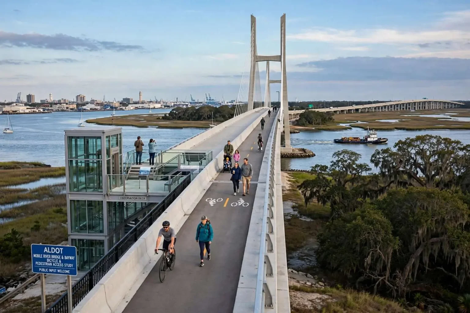
ALDOT briefed local bike and pedestrian advisory committees on new requirements for the Mobile River Bridge and Bayway project, including a required observation deck and options like a full-length bridge bike path.
State transportation officials outlined a detailed set of bicycle and pedestrian requirements this week for the proposed Mobile River Bridge and Bayway project, giving local advisory committees their clearest look yet at how walkers and cyclists could eventually cross the Mobile River and Bayway alongside vehicle traffic.
The Alabama Department of Transportation briefed members of the Mobile and Eastern Shore bicycle and pedestrian advisory committees on the requirements that any development team must meet, or at least study, before the massive bridge and highway project can move forward.
The two advisory committees — one representing the Mobile side of the harbor and one the Baldwin County communities across it — exist precisely to inject the interests of walkers and cyclists into projects of this scale, where those interests are otherwise easy to lose among the traffic counts and engineering studies that dominate a multibillion-dollar highway undertaking. ALDOT’s presentation to both committees at once signaled that the bike and pedestrian element was now written into the project’s structure rather than left as a political afterthought.
The presentation followed more than a year of public input gathered through workshops and focus groups held in 2016 and 2017. That earlier outreach found strong public support for adding bike and pedestrian facilities directly to the Mobile River Bridge itself, with residents citing the views of Mobile Bay and the potential to draw tourists as the biggest draws.
A second option, improving the existing route across the Cochrane-Africatown Bridge, also drew significant backing, in part because it would connect to bike routes that already exist or are planned in nearby communities. A third possibility, a permanent path along the Bankhead Tunnel corridor, proved least popular for everyday use, though recreational cyclists said they valued it on weekends.
The three options presented fundamentally different trade-offs. A dedicated path on the new bridge would create a destination crossing with sweeping views — the kind of signature facility that cities build once in a generation and that tourism officials covet — but it would be the costliest element and would serve a route most commuters would not ride daily. The Cochrane-Africatown route was the practical choice, threading through the historic Africatown community and tying into networks that connect Mobile’s northside neighborhoods. The Bankhead corridor option, a novelty route through the tunnel itself, offered weekend recreation rather than transportation.
What Teams Would Be Required to Build
Under the framework ALDOT presented, teams competing to design, build, finance, maintain and operate the bridge and Bayway will be required to include certain bicycle and pedestrian elements in their proposals. Those mandatory elements include upgrading the existing route along the Cochrane-Africatown corridor, from Interstate 165 and Bay Bridge Road to the east side of the bridge, and building an observation deck with an elevator and stairs on the west side of the Mobile River.
The mandatory list tells vendors where the state has drawn its line. An upgraded Africatown corridor route is the baseline commitment: it improves a crossing that exists today and serves a community whose connection to the rest of Mobile has been shaped — and cut off — by the highways built around it. The observation deck with elevator and stairs on the Mobile River’s west side builds the bridge-as-destination concept into the design contract itself, ensuring that whatever else gets value-engineered away, the public overlook survives into the final plans.
Beyond those required features, ALDOT is asking competing teams to study whether several additional options are technically and financially feasible. Those include a bicycle and pedestrian path running the full length of the new Mobile River Bridge, an extension of the Cochrane-Africatown route along Interstate 165 to Beauregard Street using a protected path carved out of the highway shoulder, and a further extension along U.S. 98 to Battleship Park.
Each of the study items would extend the network’s reach if it proves buildable. A full-length path on the new bridge would turn the span itself into the signature crossing — connecting downtown Mobile directly to the Eastern Shore by foot or bike for the first time. The I-165 extension to Beauregard Street would link the bridge route into the heart of the city’s northside neighborhoods, using protected shoulder space on a highway that already slices through them. The U.S. 98 leg to Battleship Memorial Park would complete a connection to the waterfront park and its aircraft and ship displays — a tourist endpoint that would give recreational riders a destination rather than a bridge to nowhere.
ALDOT also confirmed it plans to continue closing the Bankhead Tunnel to vehicle traffic on weekends so it can be used by pedestrians and cyclists, a seasonal practice that will remain in place as long as community interest continues.
The weekend tunnel closures — in which the 1939-vintage Bankhead, Mobile’s oldest river crossing under the downtown waterfront, is surrendered to bikes and walkers — have become a fixture of the local cycling calendar and a low-cost way for the city to test appetite for permanent facilities. The practice also carries its own logic for the bridge debate: every weekend the tunnel fills with riders is a public demonstration of demand for protected crossings that no survey can match.
Where the Project Stands
The bridge and Bayway project remains in its environmental review phase, during which ALDOT is working to complete the federally required National Environmental Policy Act process. That process includes additional opportunities for public input before it wraps up.
NEPA review is the gate through which every major federally assisted highway project must pass, documenting the proposed work’s impacts on wetlands, communities, historic sites and air quality — and, increasingly, its treatment of non-vehicular travel. The review’s public-comment windows give residents their last formal chances to weigh in on alignment, design details and mitigation before the project locks into its final shape.
Once it concludes, the Federal Highway Administration will issue a formal Record of Decision, clearing the way for ALDOT to select the private development team, known as the concessionaire, that will design, build, finance, maintain and operate the project under a public-private partnership.
The public-private partnership structure — in which a private consortium fronts capital and operates the facility, typically recovering its investment through tolls over a decades-long concession — is what makes the bike and pedestrian requirements enforceable. Because the winning team’s proposal must include the mandatory elements and price the studied options, the commitments ALDOT outlined this week become contractual obligations written into the concession agreement rather than aspirations attached to the side of the project.
Officials said a broader public meeting on the project is planned for fall 2018, where residents will be able to review environmental findings, ask questions about the public-private partnership structure, and learn more about funding, tolling and construction scheduling.
Tolling is expected to be the most contentious topic at any such meeting. The Bayway — the long elevated causeway of Interstate 10 across Mobile Bay — carries commuters between Spanish Fort and Mobile daily, and any toll on the new crossing would directly affect the households for whom that drive is a daily routine. Planners will also face questions about how toll revenue interacts with the free alternatives, including the existing Wallace Tunnel route, and whether bike and pedestrian facilities would be exempt from any toll.
The Mobile River Bridge and Bayway project calls for a new six-lane bridge across the Mobile River to add capacity to Interstate 10, along with a rebuilt eight-lane Bayway raised above the elevation of a 100-year storm surge.
The current four-lane Bayway and the Wallace Tunnel, which carries an average of 75,000 vehicles a day and up to 100,000 during peak tourist season, were built to handle far less traffic than they now carry.
Those traffic figures are the project’s core justification. The Wallace Tunnel — twin bores beneath the riverfront — and the four-lane Bayway were engineered for a metropolitan area and a beach-trafficking pattern far smaller than the one they now serve, and the bottleneck they form at the river is among the most consequential in the state: when it fails, it fails for hours at a stretch, stranding commuter and beach traffic alike. Raising the rebuilt Bayway above the 100-year storm surge elevation directly answers the vulnerability the region saw in past hurricane evacuations, when the low-lying causeway became a liability for anyone trying to leave the coast.
ALDOT has said the project is intended to cut travel times between Mobile and the Eastern Shore communities of Spanish Fort and Daphne, improve reliability for commuters heading to jobs, schools, hospitals and recreation, and give trucks carrying hazardous materials a route around downtown Mobile.
The hazmat routing point quietly addresses one of the project’s oldest safety critiques. Trucks carrying hazardous cargo are restricted from the Wallace Tunnel, leaving them to thread the surface streets or the Cochran bridge approaches through downtown — past neighborhoods, hospitals and the city’s historic core. A new high-level bridge with no tunnel restriction would give that traffic a path over the river instead of through the city, removing a category of risk that no amount of tunnel maintenance can fully retire.
For the cyclists and pedestrians whose committees heard this week’s briefing, the through-line is that their facilities are no longer competing for scraps. The requirements are mandatory, the extensions are priced into the competition, and the Record of Decision — whenever it arrives — will have the shape of the region’s walking and cycling future written into it.