Before You Dig: Extension Experts Say Mobile Homeowners Should Map Their Yard First
Alabama Cooperative Extension System specialists say Mobile-area homeowners planning a DIY landscaping project should start by mapping their site, utilities and daily foot traffic before breaking ground; free gardening programs follow this month at Mobile's Jon Archer Center.
Homeowners across the Mobile area who are itching to redo their yards this year are being encouraged to slow down and study their property before they ever pick up a shovel. Specialists with the Alabama Cooperative Extension System say the single most important step in any do-it-yourself landscaping project is one that gets skipped the most: a thorough analysis of the site itself. The advice comes with particular force along the Gulf Coast, where the long growing season makes it tempting to plant year-round and the region’s sandy, fast-draining soils punish the shortcuts that work elsewhere.
Extension horticulture advisors describe residential landscape design as a four-part process, beginning with analyzing the site and drawing up a base plan, followed by identifying the household’s needs, selecting plants and materials, and finally putting the whole design on paper. For homeowners who aren’t sure where to begin, experts say that first step deserves far more attention than it usually gets. “You can think of the site analysis as a courtship with your landscape,” is how Extension guidance frames it, urging homeowners not to rush the process. Plants may seem easy to move or replace later, but a well-thought-out design is meant to last for years, and shortcuts made early on tend to show up as regrets down the road.
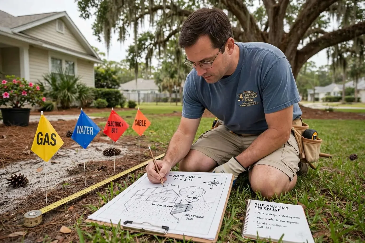
The recommended starting point is a base map: a scale drawing of the house and property, roughly one inch to every eight feet, sketched on grid paper. That map should show existing trees and plantings, the property boundaries, and which direction is north, since that determines how sunlight and prevailing wind move across the yard through the seasons. In a Mobile yard the compass matters more than newcomers expect — the sun swings high and hot through the long Gulf Coast summer, southern and western exposures bake by midafternoon, and the prevailing winds off the Gulf that moderate the humidity also drive the thunderstorms that water the yard — or flood it.
Mapping what you can see — and what you can’t
Just as important is mapping what lies beneath the surface. Homeowners are urged to note the location of overhead power lines along with underground gas, water, sewer, and cable lines before any digging begins. Anyone unsure where those utilities run is advised to call 811, a free service that will mark utility lines on a property, rather than guess and risk striking a line. A severed sewer or gas line can end a weekend DIY project in a hurry, and Extension staff say the call is worth the short wait it takes for the lines to be marked.
The 811 system exists precisely because no homeowner can see the maze below a suburban lot. Alabama’s one-call service notifies the utilities with facilities on a property, and professional locators come out to spray or flag the routes of gas, electric, water, sewer and communications lines so that a shovel — or a rented tiller, or a post-hole digger — does not find them first. The service is free to the person digging, funded by the utilities that would otherwise be repairing their own damaged lines, and in much of the country it is the law to call before excavation. Mobile County’s mix of aging neighborhoods and brand-new subdivisions makes the risk real in both directions: older districts carry decades-old service lines that may not match any modern map, and new subdivisions have utilities buried on alignments a homeowner has never seen.
Overhead lines deserve the same respect as buried ones. Planting a fast-growing tree beneath a service drop is one of the most common and most expensive mistakes in residential landscaping, because the tree that looks perfect at the nursery becomes a ten-year pruning problem and, in hurricane season, a limb-over-power-lines liability. Extension advisors urge homeowners to match a tree’s mature height and spread to its planting spot, checking the canopy’s future footprint against the lines and the house before the sapling ever leaves the pot.
The base map is also where a family’s real needs get tested against the yard’s reality. Where does water stand after a heavy Gulf Coast rain? Which corners of the lot dry out and which stay soggy for days? Where do the neighbors’ rooflines cast shade, and where does the afternoon sun land on the patio? A scale drawing with those features noted turns a vague wish list — shade, color, privacy, a place for the grill — into a plan that fits the ground it will be planted on.
Why Gulf Coast yards are different
Mobile-area landscaping carries conditions that generic national advice does not cover. The region sits in a humid subtropical climate with mild winters, so plants that would be annuals farther north can overwinter here, and the growing season stretches from early spring nearly to December. The trade-offs are equally distinctive: summer heat and humidity stress plants and gardeners alike, rainfall arrives in concentrated downpours that overwhelm compacted suburban soil, and from June through November every yard’s tree canopy has to be evaluated as potential storm debris. A design that ignores those facts fails in its first hurricane season or its first August.
Soil is the other Gulf Coast variable. Much of the area’s soil is sandy and low in organic matter, draining quickly but holding few nutrients, while low spots and clay pockets hold water long after the rain stops. Extension guidance directs homeowners to know their soil before buying plants, because the same azalea that thrives in an acid, well-drained Mobile garden bed will sulk where water pools. Improving beds with organic matter and planning drainage on the base map cost almost nothing at the design stage and are ruinously expensive to retrofit after the plants are in the ground.
Then there is the region’s plant heritage. Mobile’s gardens have long been famous for azaleas, camellias and the mature live oaks that shade its historic districts, and the Extension System’s recommendations for the area build on that palette — plants suited to heat, humidity, salt air near the bay, and the occasional hard freeze that still reaches the Gulf Coast in winter. Choosing plants that belong in this climate is the quiet difference between a yard that thickens over five years and one that becomes an annual replanting bill.
Who is behind the advice
The Alabama Cooperative Extension System is the state’s outreach arm for practical knowledge, operating as a partnership between Auburn University and Alabama A&M University with offices in every county, including Mobile. Its horticulture advisors answer homeowners’ questions about lawns, gardens, trees and pests, run master gardener training, and publish guidance — including landscape design worksheets — aimed at do-it-yourselfers rather than professionals. For a homeowner staring at a blank base map, the county Extension office is a free first stop, and the advice comes grounded in what actually grows in Gulf Coast conditions.
The four-part process Extension advisors teach is deliberately old-fashioned, and that is its virtue. Analyze the site, draw the base plan, list the household’s needs, select plants and materials, and only then put the full design on paper. The order prevents the most common DIY failure: buying plants first and deciding where they go later. A cart of impulse purchases from a spring garden center almost never fits the site it lands in, and the cost of that mismatch — lost plants, wasted water, repeated replacements — is what the site analysis is designed to prevent.
Utility awareness sits inside that same discipline. A design drawn without knowing where the gas line runs may place a new shade tree directly over it, and a tree over a gas line is not merely a landscaping problem — it is a utility easement problem that can require removing the tree the day it matures. Extension staff fold the 811 call into the design phase itself, not the planting phase, so that the base map already shows what is underground before any plant is chosen for any spot.
Putting the design on paper
Once the base map exists and the utilities are marked, the household’s needs take center stage. Extension advisors suggest walking the property with the family and listing what the yard must do: where children and pets play, where trash cans and utility meters sit, where the driveway runoff goes, where a screened sitting area would actually get used, and which views from the house deserve framing or screening. Each need is sketched onto the map as a bubble or zone before any plant is discussed. That step converts a shopping list into a program — and it frequently surprises homeowners by showing that the lawn they planned to shrink was the only usable play space, or that the flower bed they imagined belongs where the septic or utility easement forbids planting anything deep-rooted.
Plant and material selection comes third, and on the Gulf Coast it should lean heavily on plants proven in local conditions. Trees that hold their canopies in high wind, shrubs that tolerate humidity and the pests that come with it, and ground covers that survive August without daily watering all earn their place. Materials matter the same way: porous paving and gravel handle downpours better than solid concrete that sheets water toward the house, and raised beds on the wet side of the lot can turn a drainage problem into a planting opportunity.
Finally, the whole design goes on paper — a completed plan showing beds, trees, hardscape, irrigation and lighting drawn to the same one-inch-to-eight-feet scale as the base map. The finished drawing is what a homeowner takes to a nursery, shows a contractor or prices out in stages over several years. It also becomes the record of what was planted where, which matters more than it sounds when a utility locator arrives years later, or when a storm takes a limb and the replacement tree has to match what was lost.
The cost of skipping the first step
The Extension System’s warning is blunt because the failures it describes are common and expensive. Trees planted over buried lines get removed at maturity by utility crews. Shrubs set under a service drop get sheared into hedges by line-clearance crews every few years. Tomatoes and camellias planted in full shade never perform. Beds graded without attention to runoff send every Gulf Coast downpour against the foundation instead of into the yard. Almost all of it traces back to the same skipped step — the walk around the property, the scale map and the call to 811 before the first hole is dug.
The remedy costs little. Grid paper and a tape measure produce the base map in an afternoon. The 811 call is free, and its wait for line marking is measured in days, not weeks. The county Extension office supplies plant lists suited to Mobile’s climate and can review a plan’s plant choices before money is spent. A weekend of measuring and sketching, done before the first trip to a garden center, is the cheapest insurance a Gulf Coast homeowner can buy on what is usually the largest planted investment on the property — the yard itself.
For Mobile homeowners planning this year’s project, the sequence Extension advisors recommend is worth repeating in order: analyze the site, draw the base map at one inch to eight feet, mark the overhead and buried utilities with a free call to 811, list the household’s needs, choose plants that belong in the Gulf Coast climate, and only then put the full design on paper. The shovel can wait a week. The utilities, the drainage and the sun cannot be negotiated with after the planting is done — and the homeowners who learn that from a map rather than a mistake are the ones whose yards are still standing, and thriving, five hurricanes from now.