Blakeley Island Rezoning Would Shift 22 Waterfront Acres to Heavy Industrial Use
A marine construction company wants nearly 22 acres along Cochrane Causeway rezoned from residential to heavy industrial. The Mobile Planning Commission recommended approval, and the City Council holds a public hearing Nov. 3.
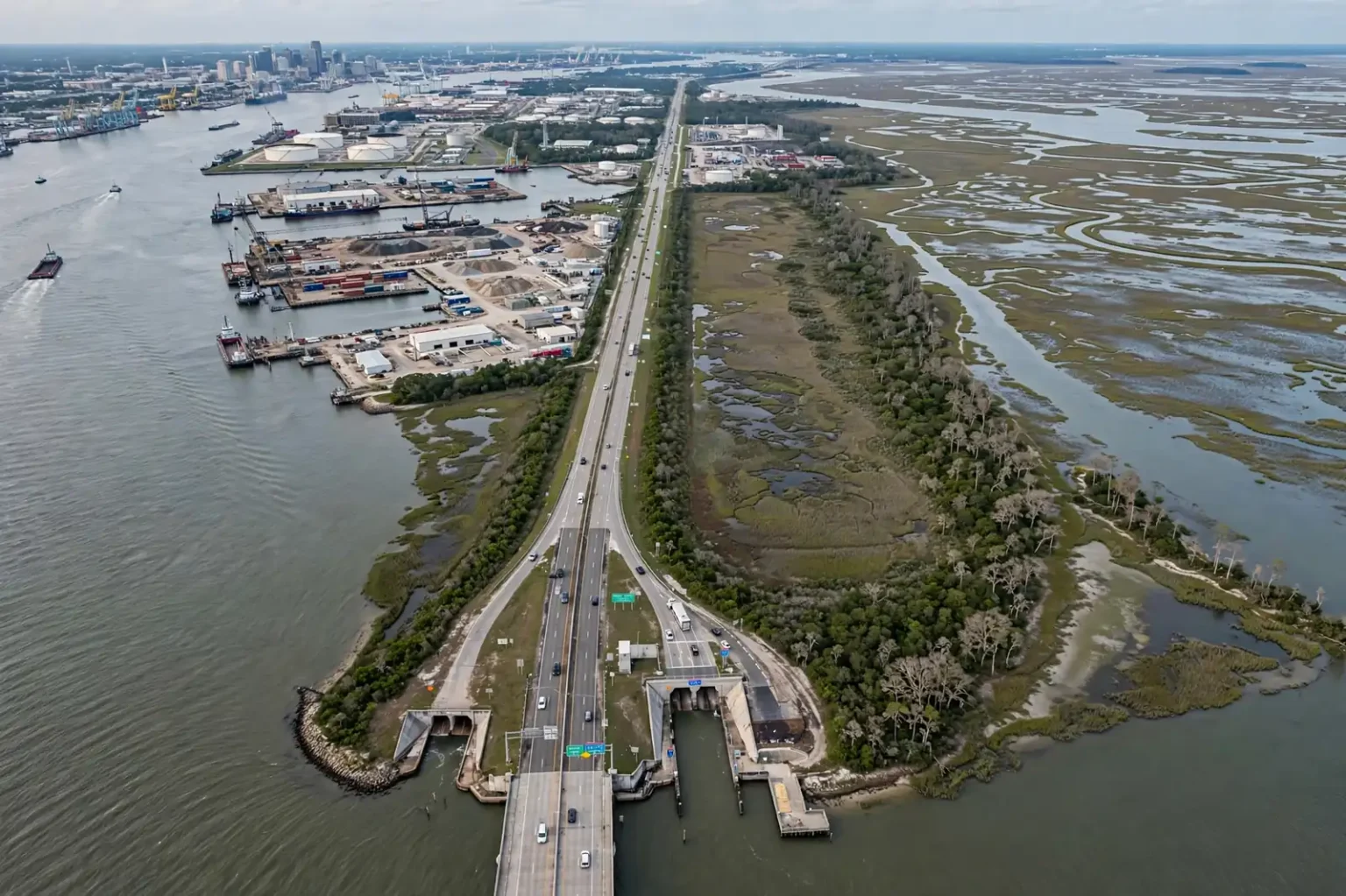
MOBILE, Ala. — A marine construction company is asking the city to reclassify nearly 22 acres of vacant waterfront land on Blakeley Island from single-family residential to heavy industrial, a Blakeley Island rezoning request that now heads to the Mobile City Council after winning a favorable recommendation from the Mobile Planning Commission.
The property, owned by Telcon LLC, lies along Cochrane Causeway just north of where the Bankhead and Wallace tunnels surface on the island. According to the owner, the land should have carried an industrial designation decades ago, and its residential label may be the product of a mapping error. Telcon has not put forward any plans to build on the site.
The Planning Commission voted on Sept. 17 to recommend that the City Council approve the change, which would move the tract from the R-1 single-family residential district to the I-2 heavy industry district. The council has the final say and has scheduled a public hearing on the request for Nov. 3.
The property and its owner
The parcel measures 21.92 acres and runs from Cochrane Causeway eastward to Pole Cat Bay, one of the shallow bays that open onto the wider Mobile-Tensaw Delta. Most of the land around it is already devoted to industrial and marine uses.
Telcon bought the property in October 2025 from Celeste Land Development LLC for $250,000, according to Mobile County property records. Alabama business records list Tellier Kenny in connection with the company, and state general contractor licensing records identify Telcon as a marine construction firm.
In its request to city planners, the company framed the application less as a change in direction for the land than as a correction. If the residential designation was indeed a mapping mistake, the rezoning would bring the official zoning map in line with how the surrounding area has actually been used for generations.
Because no development has been proposed, the rezoning by itself would not authorize any particular project. Any future construction would still need to go through the city’s permitting process and meet the requirements that apply to the I-2 district, along with any applicable state and federal rules for work along the water.
A working island
Blakeley Island sits directly across the Mobile River from downtown Mobile and has long been one of the most heavily industrialized pieces of ground in the region. Its location — at the mouth of the river, beside the deepwater ship channel and astride the main routes between Mobile and the Eastern Shore — has made it a natural fit for businesses that depend on the water.
Today, the island is home to storage tank facilities, shipbuilding operations and marine cargo services. Barges, tugs and oceangoing vessels move along its western edge, and the industries there are tied closely to the Port of Mobile, one of the busiest ports on the Gulf Coast.
Large portions of the island have also been used over the years to hold dredged material removed from Mobile’s ship channel and waterways. Keeping the channel deep enough for modern ships requires regular maintenance dredging, and the sediment pulled from the bottom has to go somewhere. Areas set aside for that purpose are generally not suited to ordinary construction, which has helped limit conventional development across much of the island.
Residential neighborhoods, by contrast, are essentially absent from Blakeley Island. That is part of why an R-1 classification on a waterfront tract surrounded by industry stands out, and why the owner contends the designation never matched reality.
Tunnels, causeway and the delta
The property’s address on Cochrane Causeway places it along one of the most traveled corridors in the area. The Bankhead Tunnel carries traffic beneath the Mobile River between downtown and Blakeley Island, while the larger George C. Wallace Tunnel carries Interstate 10 under the river. Both emerge on the island, and drivers heading north along the causeway pass the area where the Telcon property is located.
To the east, Pole Cat Bay forms the property’s back boundary. The bay is part of the broad network of rivers, bayous, marshes and open water at the head of Mobile Bay known as the Mobile-Tensaw Delta, one of the largest river delta systems in the United States and an area widely recognized for its biological diversity.
That setting means any eventual use of the land could draw interest not only from neighboring businesses but also from people who care about the health of the delta and its waters. Work in or near wetlands and navigable waters is generally subject to review by state and federal agencies, separate from local zoning.
What R-1 and I-2 mean
Zoning is the tool cities use to sort land into districts and spell out what can be built in each one. Mobile’s development rules divide the city into residential, commercial and industrial districts, among others, each with its own list of permitted uses, building standards and requirements.
The two districts at issue in this case sit at opposite ends of that spectrum:
- R-1, the single-family residential district, is intended primarily for detached single-family homes and closely related uses.
- I-2, the heavy industry district, is designed for more intensive industrial operations — the kinds of uses typically kept away from neighborhoods because of their size, traffic, noise or other impacts.
Moving a tract from one to the other is a significant change on paper. In practical terms, however, the property’s surroundings are already industrial and marine in nature, and the owner argues the residential label is an anomaly rather than a reflection of the neighborhood.
How a rezoning works in Mobile
In Mobile, a request to change a property’s zoning goes through two bodies.
First, the application is reviewed by city planning staff and taken up by the Mobile Planning Commission, an appointed board that considers land-use matters. The commission holds a public hearing, considers the staff analysis and any comments from the public, and then votes on whether to recommend approval or denial. In this case, the commission recommended approval on Sept. 17.
Second, because a rezoning amends the city’s official zoning map, it must be approved by the Mobile City Council. The council holds its own public hearing before voting. That hearing on the Telcon request is set for Nov. 3.
Between those two steps, the public has an opportunity to weigh in. Residents, nearby property owners, businesses and organizations can speak at the council’s public hearing or contact their council members ahead of time. The council can approve the rezoning, deny it, or delay action, and it is not bound by the Planning Commission’s recommendation.
Why mapping errors happen
Zoning maps in older American cities were often drawn decades ago and updated piece by piece over time. Large, undeveloped or hard-to-reach parcels — like low-lying waterfront land used for dredge disposal — did not always get careful attention when district lines were drawn, and some ended up with designations that never matched their use or their surroundings.
When an owner believes a parcel was mislabeled, the usual remedy is the same one Telcon is pursuing: a formal rezoning application that goes through public review and a vote of the governing body. That process gives the city a chance to examine the request and gives the public a chance to be heard, even when the change is described as a correction.
Why it matters
Industrial land along deep water is a limited commodity. Much of the shoreline around Mobile Bay is already developed, protected or otherwise unavailable, and businesses that need direct access to the water — shipbuilders, marine contractors, cargo handlers and terminal operators — have few places to go.
For that reason, how the city classifies waterfront parcels on Blakeley Island has implications for the local economy. A heavy industrial designation would align the Telcon tract with the island’s established character and could make it easier for the land to be put to a water-dependent use in the future, though no such use has been proposed.
At the same time, rezoning decisions are permanent in a way that individual projects are not. Once a property is placed in a heavy industrial district, a range of uses allowed in that district could be pursued later without another zoning vote. That is one reason the council’s public hearing exists: to give anyone with an interest in the property’s future a chance to raise questions before the decision is made.
What’s next
The Mobile City Council will hold its public hearing on the proposed rezoning on Nov. 3. The council’s agendas are posted in advance by the city, and residents who wish to comment can attend the meeting or reach out to their council member.
If the council approves the change, the 21.92-acre tract would be reclassified from R-1 to I-2. Because Telcon has not announced a development, any specific plans for the site would come later and would face their own review.
If the council declines, the property would remain in the residential district, despite being surrounded by industrial and marine operations on an island where few people live.
Either way, the decision will add another chapter to the long story of Blakeley Island — a stretch of land that has been shaped for generations by the river, the ship channel and the industries that rely on them.