Dauphin Island Begins Cleanup After Tropical Storm Cristobal Floods West End
Tropical Storm Cristobal flooded Dauphin Island's west end, pushing up to five feet of sand across roads as crews began pumping and clearing Monday.
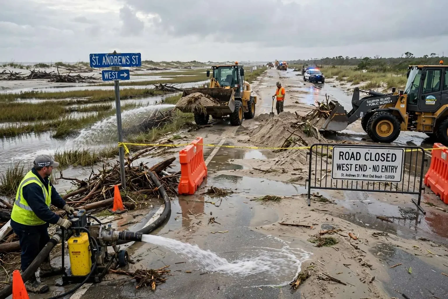
Crews on Dauphin Island started pumping out floodwater and clearing debris Monday morning after Tropical Storm Cristobal sent water and sand washing over roads in south Mobile County. The work began while residents were still sorting out which routes on the barrier island were passable and which stretches remained buried under a layer of Gulf sand dragged ashore by the storm.
Police closed off the island’s West End on Sunday as storm water and debris began washing across the roadway. By Monday morning, pumps were in place and the cleanup was underway, with town crews concentrating first on the low-lying sections where standing water kept residents from reaching their properties and kept emergency vehicles from moving freely.
Dauphin Island occupies a narrow barrier spit at the mouth of Mobile Bay, and its western end is among the most flood-prone stretches of the Alabama coast. The island shields the bay and the mainland from storms moving in from the Gulf, and it pays for that role regularly: low dune lines and long, flat topography mean that even tropical systems that make landfall well to the west can push Gulf water and sand across the only road that serves the western half of the town.
That geography was on full display as Cristobal moved through the Gulf. Water did not simply pond in streets after the rain ended; it flowed across the roadway in sheets, carrying sand from the beach side and depositing it along the route that residents use to reach the West End Beach. For a town with a single main corridor serving its western neighborhoods, an overwash event effectively severs one part of the community from the other until crews can reopen the road.
Town officials have long treated West End overwash as a recurring cost of island life. After significant coastal storms, the typical sequence is familiar to locals: the road closes while water and sand are still moving, public works brings in pumps to clear standing water, heavy equipment scrapes and hauls sand off the pavement, and the route reopens in stages as conditions allow. Monday’s operation followed that pattern, with the added complication that debris scattered by the storm had to be cleared before traffic could safely return.
The early cleanup push also reflected the town’s experience with storms in the 2020 Atlantic hurricane season, which was already producing named systems well before the traditional peak of the season. Coastal communities across south Mobile County spent the day assessing what Cristobal left behind, and on Dauphin Island the answer was measured in water on the roads and sand where sand had no business being.
Water and Sand Across the Roads
Water covered stretches of the road leading to the West End Beach from St. Andrews Street, forcing drivers to turn back before they could reach the western tip of the island. The flooded section was not a brief puddle at a low spot; it was a sustained stretch of standing water deep enough that even residents accustomed to driving through minor street flooding after coastal storms decided the risk was not worth it.
“I had to turn around, I’m in my car so I ain’t taking no chances,” said Fenis Perryman, who tried to drive the west end route. “I made it about as far as St. Stephens road, had to turn around.”
Perryman’s experience was common among islanders who attempted the drive Sunday and Monday. With the West End closed by police and water still moving across the pavement from St. Andrews Street westward, most drivers who set out had little choice but to reverse course well short of their destination. The turnaround point Perryman described became, for a time, the practical edge of the drivable island.
The damage was not limited to standing water. Building official Corey Moore said some spots had roughly five feet of sand spread across the road, a depth that turns a cleanup from a pumping job into a major earth-moving operation. Sand overwash of that magnitude requires front-end loaders and dump trucks making repeated passes, and it can bury pavement features, driveways and drainage structures along the affected stretch.
Deep sand deposits are a signature of barrier island storm impacts. When surge and waves overtop the beach and dune line, the water loses energy as it crosses the island and drops its sediment load on the first flat ground it finds — which on Dauphin Island’s West End is the roadway itself. A storm does not need to be a major hurricane to produce that effect; a strong tropical storm with a prolonged onshore flow can move enough sand to shut a road for days.
For residents, the sand is a double burden. It blocks access while crews work, and it leaves the road surface changed after the water recedes, with shoulders, edges and pavement markings hidden under a fresh layer of Gulf sediment. Clearing it is slow, deliberate work, and town officials generally ask drivers to stay off closed sections until equipment has finished, both for safety and to keep the cleanup moving.
Getting Onto the Island Was Its Own Challenge
While crews fought water and sand on the island itself, simply getting onto Dauphin Island became its own obstacle Monday. The Alabama Department of Transportation set up a roadblock at Dauphin Island Parkway and Highway 188, about eight miles from the island, controlling access to the bridge route across the bay waters of south Mobile County.
Around 7 a.m., vehicles were being allowed across only with an escort. The staged roadblock gave officials a way to meter traffic onto the island while cleanup operations were still underway, keeping sightseers and nonessential trips out and letting residents, utility workers and equipment move in an orderly fashion. Checkpoints of this kind are standard practice after coastal storm events in south Mobile County, where a single access route makes crowd and traffic control manageable but also means any bottleneck is felt immediately.
Dauphin Island Parkway, often called the DI Parkway by locals, runs south from the Highway 188 junction to the Gordon Persons Bridge, the span that carries traffic onto the island. Because the parkway crosses low ground and open water on its way to the bridge, it is vulnerable to the same wind, rain and surge effects that hammer the island, and state transportation crews routinely inspect it for debris and standing water before reopening it to unrestricted travel after a storm.
The escort-only arrangement also served a practical purpose for emergency management. By controlling each vehicle movement, officials could ensure that the people entering the island were ones with a genuine need to be there, and that the island would not fill up with curious drivers while pumps were still running and heavy equipment was still working on the sand-covered road.
For mainland residents in south Mobile County, the roadblock was a visible reminder of how the region absorbs a storm. Communities such as Bayou La Batre, Coden and Mon Louis Island line the same low-lying coastline, and flooding from a Gulf system rarely respects municipal boundaries. Highway 188 and the parkway serve as lifelines for all of them, which is why access control points are typically placed inland, at junctions where traffic can be turned around safely before it reaches vulnerable low ground.
A Familiar Routine for the Barrier Island
Tropical Storm Cristobal arrived early in the 2020 Atlantic hurricane season, an unusually active start to a year that kept Gulf Coast residents on alert from the opening weeks of June onward. The system’s track across the Gulf sent bands of wind and water against the northern Gulf Coast, and Alabama’s barrier islands took the brunt of the onshore flow even where the storm’s center stayed well to the west.
For Dauphin Island, the pattern was familiar. The town has rebuilt its West End repeatedly after hurricanes and tropical storms, and each event follows a rhythm: water and sand over the road, a closure, pumps and heavy equipment, an escorted reopening, and a return to whatever passes for normal on a barrier island. What changes from storm to storm is the depth of the sand and the length of the closure.
Local officials consistently use events like this one to reinforce the same messages to residents and property owners. Do not drive through water of unknown depth, both because vehicles stall in it and because the road surface underneath may be undermined. Stay clear of closed sections while crews work. And expect access controls to remain in place until the island is safe for unrestricted travel, even if that means waiting while an escort leads vehicles across the bridge route.
What the Cleanup Means for Residents
By Monday morning the visible signs of recovery were already in place: pumps humming at flooded stretches, loaders working the deepest sand deposits, and police holding the West End closed until the route could be made passable. The town’s building officials and public works staff were documenting conditions as they went, the first step in the assessment process that follows every coastal storm and shapes repair priorities.
For the residents of the West End, the priority was simple — getting back to their homes. For the town, the priority was restoring the road that connects them. Neither happens quickly after a storm pushes five feet of sand onto a roadway, but Monday’s progress marked the start of the routine that Dauphin Island has repeated after every coastal blow: clear the water, move the sand, reopen the road, and watch the next system as it forms in the tropics.
Drivers planning to travel to the island in the days after the storm were advised to check on access conditions before setting out, since closures and escort requirements can change hourly as cleanup progresses. The Alabama Department of Transportation and town officials planned to relax restrictions as conditions allowed, restoring normal traffic flow to the island’s main route once the sand was cleared and the roadway was safe.