Tar Balls Reached Dauphin Island in May 2010
A 2010 WKRG report said tar balls believed connected to the Gulf oil spill began washing ashore on Dauphin Island.
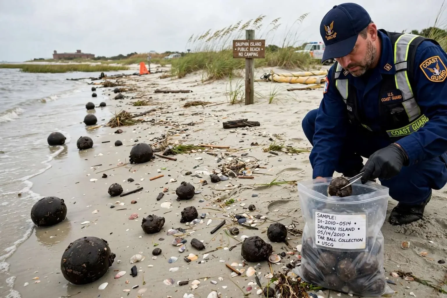
Tar balls believed to be connected to the Gulf of Mexico oil spill began washing ashore on Dauphin Island in May 2010, according to a local station’s report from the time. The small barrier island at the entrance to Mobile Bay, long accustomed to sharing its beaches with seashells and driftwood, suddenly found itself on the front edge of a spill that would become the largest marine oil spill in United States history. The arrival of the tar balls turned an offshore disaster into something residents and visitors could see and pick up with their own hands.
A Coast Guard official said several of the tar balls had been collected and would need testing, though officials believed they came from the spill. That caution was characteristic of the early weeks of the response. Tar balls can, in rare cases, have natural sources such as seeps on the Gulf floor, and responders wanted laboratory confirmation before drawing firm conclusions. But the timing, the location, and the appearance of the waxy, dark-brown clumps left little doubt among locals about where they had come from, and the confirmation process proceeded even as more material continued to arrive.
The Disaster Behind the Tar Balls
The Deepwater Horizon drilling rig had exploded on April 20, 2010, roughly 40 miles off the Louisiana coast, killing 11 workers and triggering a blowout at the Macondo well nearly a mile beneath the surface of the Gulf. For weeks, oil flowed unchecked from the wellhead while engineers attempted one containment strategy after another. By the time the well was finally capped in mid-July 2010, an estimated 3.19 million barrels of crude had entered the Gulf, according to the federal government’s flow-rate assessment, dwarfing the 1989 Exxon Valdez spill by an order of magnitude.
As the crude moved with currents and weather across the northern Gulf, it changed form. Lighter components of the oil evaporated or dissolved, and wave action churned the remainder into emulsified “mousse” and, eventually, into tar balls — small to large agglomerations of weathered oil that can travel hundreds of miles. Because weathered tar balls are denser and stickier than fresh crude, they tend to ride just below the surface or wash onto beaches rather than forming the visible slicks seen near the wellhead, which made them harder to track from aircraft and more likely to catch beach towns by surprise.
Why Dauphin Island Was in the Path
Dauphin Island’s geography placed it squarely in the projected path of spill impacts. The island is a low-lying barrier island protecting the entrance to Mobile Bay, oriented east-west just off the Alabama coast. Its eastern end, anchored by the historic Fort Gaines, faces the open Gulf, while the sound side looks across toward the mainland communities of the Mobile Bay area. Modeling of the spill’s trajectory repeatedly flagged the Alabama coastline, including Dauphin Island, Orange Beach, and Gulf Shores, among the areas most likely to see oiling as plumes moved east from the wellhead.
The island’s economy is built almost entirely on its relationship with the water. Vacation rentals, seafood harvesting, charter fishing, and the ferry connection to Fort Morgan all depend on clean beaches and a healthy bay. In May 2010, as Memorial Day approached and the summer season hung in the balance, the sight of tar balls on the sand was not merely an environmental event but a commercial threat. Homeowners and rental managers watched the daily trajectory maps as closely as any hurricane forecast, and fishing grounds in state waters had already begun closing as a precaution.
How the Response Worked
The collection and testing of the Dauphin Island tar balls followed the structure of the broader federal response, which was led by the Coast Guard under the Oil Pollution Act’s framework, with BP designated the responsible party. Unified Area Command coordinated operations across the Gulf states, while each state ran its own unified command. In Alabama, response workers staged along the beaches, and trained crews conducted shoreline cleanup assessments to document oiling conditions segment by segment. Tar balls found on the sand were collected by hand or with light equipment, bagged, and documented.
Testing served two purposes. Scientifically, fingerprinting the oil through gas chromatography can match the petroleum hydrocarbons in a tar ball to the Macondo well’s distinctive chemical signature, distinguishing spill oil from tar of natural seep origin. Practically, the results determined how the material was handled and, later, how cleanup claims and damages were documented. Along the Gulf Coast throughout the summer of 2010, this same process played out on beach after beach, with finding teams, cleanup crews, and monitors working dawn shifts to remove oil before it could bake into the sand.
The Long Shadow of 2010
Dauphin Island’s encounter with the spill did not end when the first tar balls were bagged. Oil impacts recurred across the island’s beaches through the summer and reappeared in subsequent years, with tar mats and oiled debris surfacing after storms and tropical systems stirred the Gulf floor. The 2012 settlement of economic and property damage claims, and the 2015-2016 resolution of the larger environmental settlement under the Oil Pollution Act, allocated billions of dollars across the Gulf states for restoration, with Alabama’s share directed toward coastal protection, habitat restoration, and tourism recovery.
The spill also left a lasting imprint on how coastal Alabama prepares for marine pollution. Area Contingency Plans were revised, boom deployment strategies for Mobile Bay and its passes were refined, and the Deepwater Horizon Oil Spill Final Programmatic Damage Assessment and Restoration Plan created a standing restoration framework that continues to fund projects today. For residents of Dauphin Island, May 2010 remains the moment when a distant rig explosion became their problem, one tar ball at a time, washing up on the same beaches where their children had collected shells the summer before.
Understanding Tar Balls Themselves
Tar balls are one of the most common and persistent forms in which spilled oil reaches a shoreline. When crude oil weathers at sea — losing its lighter fractions to evaporation, mixing with seawater through wave action, and picking up suspended sediment — it thickens into sticky, semi-solid lumps ranging from the size of a coin to discs the size of a dinner plate. Because weathered oil is less toxic than fresh crude, health officials generally considered incidental skin contact with tar balls during the 2010 spill to be a minor risk, though they advised beachgoers to avoid touching the material and to keep pets away from oiled sand.
That relative harmlessness to individuals did not make tar balls harmless to the coast. They foul the intertidal zone, coat shells and wrack lines, require labor-intensive removal, and deter the beach visits on which barrier island economies depend. On Dauphin Island, where the public beach and the western end’s rental neighborhoods draw families from across the Southeast each summer, even scattered tar balls in May represented a season-defining problem if they could not be kept off the sand through the peak months.
A Warning About This Report
This article is a historical summary of an early 2010 oil-spill report, not a current beach-condition report. Beach conditions on Dauphin Island and along the Alabama coast today are unrelated to the events of May 2010, and anyone planning a visit should consult current local sources for present-day information about water quality, beach flag conditions, and public safety. The Deepwater Horizon response ended years ago, and the beaches of coastal Alabama have long since returned to normal recreational use.
Commercial fishing felt the pressure immediately as well. Alabama’s seafood industry, centered on oysters, shrimp, and finfish harvested from Mobile Bay and state waters, saw harvesting areas closed as a precaution even before oil reached the shore, and dockside prices collapsed as consumers questioned the safety of Gulf seafood regardless of official testing. Restaurants and wholesalers in Bayou La Batre and across coastal Alabama filed damage claims alongside the charter fleets and rental owners, and the claims process that followed would eventually process hundreds of thousands of submissions across the five Gulf states and beyond.
What the May 2010 tar balls on Dauphin Island preserve, more than a decade later, is a snapshot of the spill’s earliest reach into Alabama waters: a Coast Guard official confirming that several tar balls had been collected and would need testing, officials expressing their belief that the material came from the spill, and a barrier island community beginning to grasp the scale of what was drifting toward its shores. Those first confirmed arrivals in May 2010 marked the beginning of Alabama’s longest and most demanding environmental recovery, one that would span years of cleanup, claims, litigation, and restoration work along the entire Gulf Coast.