Oil Globs Coated Dauphin Island in June 2010
A 2010 WKRG report documented oil globs coating parts of Dauphin Island as the Gulf spill response continued.
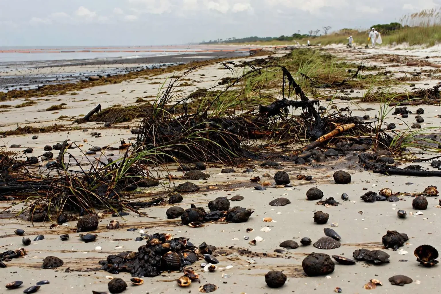
Oil globs had washed ashore on Dauphin Island by June 2010, nearly six weeks after the Gulf oil leak began, according to a local station. An LSU associate professor studying the material described it as melting in the sun and coating grass, wood and shells. The report also covered ongoing efforts to contain the offshore leak. This is a historical summary of 2010 oil-spill reporting, not a current beach-condition report.
The arrival of oil on Dauphin Island’s beaches in June 2010 marked a turning point in the Deepwater Horizon disaster for Alabama’s coast. The rig had exploded roughly six weeks earlier, on April 20, 2010, killing eleven workers and setting off the largest marine oil spill in American history, and for weeks afterward residents of the barrier island had watched the sea with a question no one could answer: when, and where, would the oil come ashore? By early June, the answer had arrived in the form of globs and tar-like material scattered across the sand and wrack lines.
Dauphin Island, the barrier island that guards the entrance to Mobile Bay, was among the first Alabama locations to feel the spill’s physical reach. Its south-facing beaches take the brunt of whatever the Gulf delivers, and in the summer of 2010 that meant repeated waves of weathered oil — not the fresh crude flowing from the damaged wellhead a hundred miles offshore, but a transformed material that had traveled through warm, sunlit water for days or weeks before landfall.
What “melting in the sun” oil really was
The description offered by the LSU associate professor who examined the material — that it was melting in the sun and coating grass, wood and shells — captured the strange behavior of weathered crude. As oil weathers at sea, its lighter compounds evaporate and dissolve, leaving a heavier, sticky residue that softens in the intense Gulf sun. On a beach in June heat, that residue could smear across anything it touched, gluing layers of sand together, darkening the shells of the island’s famous shelling grounds, and staining the grass and driftwood along the high-tide line.
That stickiness is what made the material so difficult to deal with. Cleanup crews could collect patties and globs by hand and with mesh screens, but the thinnest coatings clung to vegetation and debris and defied quick removal. On a barrier island like Dauphin Island, where the beaches are both an ecological zone and an economic engine, cleanup had to balance the removal of oil against the damage heavy equipment could do to the dunes and the nesting habitat that the island supports.
The June landfalls also changed the tone of the disaster locally. Until oil actually arrives, a spill is a threat that can be planned for; once it lands, it becomes a daily, visible problem that residents, tourists, and public officials confront with rakes, shovels, and workers in white suits. The local station’s report, coming as it did six weeks into the crisis, documented the moment when anticipation gave way to evidence on the sand.
What the spill meant for Dauphin Island
The economic stakes for the island were enormous. Dauphin Island’s summer economy is built on the beach — vacation rentals, the ferry to Fort Morgan, fishing charters, and the day visitors who cross the bridge from the mainland to spend an afternoon on the sand. Tarred beaches in June, at the start of the peak season, threatened all of it, and the psychological effect was as real as the physical one: images of oil-coated sand on the evening news did damage even where the oil itself was spotty.
The island’s ecology faced its own reckoning. Dauphin Island’s dunes, salt marshes, and the Audubon Bird Sanctuary that occupies its eastern end support migrating birds, nesting sea turtles, and a wide range of coastal species. Weathered oil on the beach posed a threat to wildlife that ingested or became coated by it, and responders worked to protect sensitive habitat with boom and to keep cleanup activity from compounding the harm.
The spill also etched itself into the island’s long history of adversity. Dauphin Island has been battered by hurricanes repeatedly — Frederic, Georges, Katrina, and others — and residents are accustomed to rebuilding. But an oil spill was different in kind: slow-moving, uncertain in duration, and visible in the form of globs on the sand that no amount of chain-saw and plywood repair could address. The summer of 2010 became a shared memory on the island, invoked in later years whenever offshore drilling and coastal protection were debated.
The long aftermath on Alabama’s coast
The oil that came ashore in June 2010 was only the beginning of years of work. Beaches were cleaned through the summer and fall, and cleanup operations continued into subsequent years, with periodic re-oiling pushing tar back onto the sand after storms stirred submerged oil from the seafloor. The legal aftermath was longer still: the criminal and civil cases against the companies involved produced multibillion-dollar settlements, and the RESTORE Act channeled a large share of the Clean Water Act penalties back to the Gulf Coast states for restoration and economic recovery.
Scientific attention to the spill has continued ever since. Researchers, including those at Louisiana State University and the universities along the northern Gulf, have studied where the oil went, how it weathered, and what its effects have been on fisheries, marshes, and offshore ecosystems. The material that washed ashore on Dauphin Island — the melting, coating residue described in the June 2010 reporting — became one small piece of an enormous body of research into the behavior of oil in the marine environment.
Today, Dauphin Island’s beaches are monitored regularly, and tar balls still occasionally appear on Gulf beaches after storms, as they did long before 2010 from natural seeps and shipping. But the scale of the 2010 landfalls has not recurred, and the island has returned to its familiar rhythms of shelling, fishing, and seasonal visitors.
The containment fight offshore
While globs washed ashore, the larger story remained offshore, where efforts to contain the leak were proceeding on an unprecedented scale. By June 2010, response crews had deployed thousands of feet of containment boom along the coastline and in the passes of the barrier islands, skimming vessels were collecting oil where they could reach it, and controlled burns were consuming slicks on the open water. Beneath the surface, engineers were working through a series of improvised devices — a containment dome that failed when hydrates clogged it, a “top hat” smaller insertion tube that captured some of the flow, and the “top kill” attempt to plug the well with heavy drilling mud that did not succeed.
None of those measures stopped the flow entirely until a cap was fitted over the well in mid-July 2010, and the well was not permanently sealed until a relief hole intersected it that September. In June, the uncertainty was itself part of the emergency: no one could say with confidence how long the leak would continue or how much oil would ultimately reach the northern Gulf coast, and that uncertainty drove every decision from closing fishing grounds to positioning cleanup assets.
For Alabama, the state’s response included placing booms around the passes of Mobile Bay and Perdido Bay, stationing skimmers, and preparing beaches for the arrival of oil that officials knew they could not entirely prevent. Dauphin Island, sitting closest to the open Gulf, was on the front line of all of it.
Looking back from the present
Reporting from June 2010 — the globs on the beach, the professor’s description of oil melting in the sun and coating grass, wood and shells, the coverage of containment efforts still underway offshore — preserves a picture of the coast at the moment the disaster became tangible. It is a historical record now, and it should be read as one: nothing in it describes current beach conditions on Dauphin Island, and visitors today will find the island conducting its usual business as a barrier-island community and tourist destination.
What the episode left behind is twofold. On one hand, a changed regulatory and response landscape, with stricter oversight of offshore drilling and a more practiced spill-response network along the Gulf. On the other, a durable local lesson about the connection between the deep sea and the beach: that the waters offshore, a hundred miles out, and the sand under a beach umbrella on Dauphin Island are parts of a single system, and that what happens in one eventually shows up in the other.
The June 2010 report of oil globs washing ashore six weeks into the leak remains a reference point for coastal residents, journalists, and researchers who study the spill. It marks the moment when Alabama’s barrier island first displayed, in sticky black relief, the reach of the disaster — and it stands today as history, not as a description of the island’s present beaches.