Gulf Shores Locks In Permanent Protection for 836 Acres of Oyster Bay Wetlands
Gulf Shores has placed 836 acres of wetlands along Oyster Bay under a permanent conservation easement, protecting the land from future development and funding habitat restoration through a federal Deepwater Horizon settlement program.
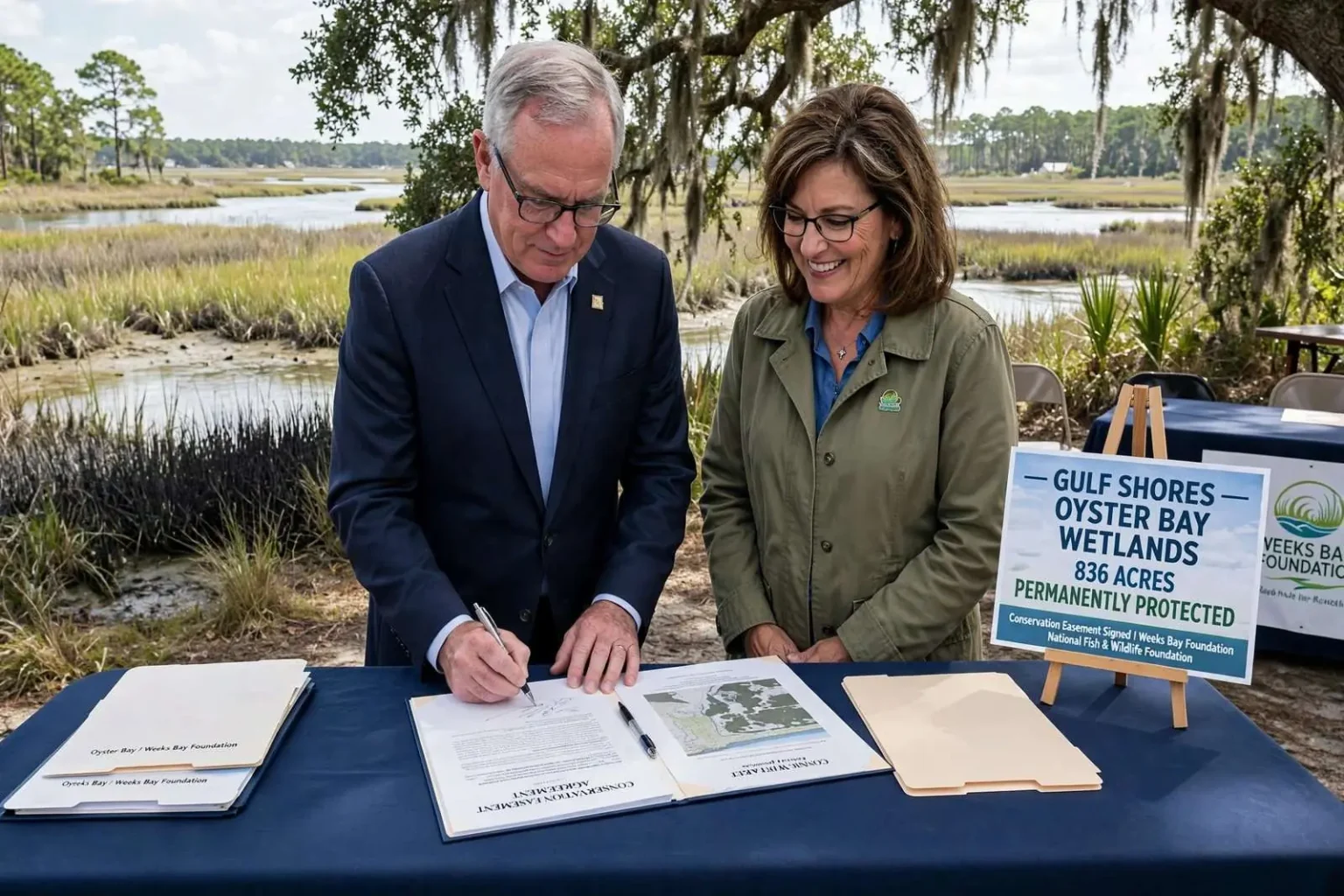
Gulf Shores Mayor Robert Craft signed closing documents this week placing 836 acres of wetlands along the eastern shore of Oyster Bay under a permanent conservation easement, ensuring the property can never be developed and setting the stage for a long-term restoration of fish and wildlife habitat in the area. Craft signed the agreement alongside Weeks Bay Foundation Executive Director Connie Whitaker, formalizing years of planning aimed at protecting one of Baldwin County’s more significant remaining tracts of undeveloped coastal wetland. The ceremony marked the culmination of a multi-year effort that brought together city, state, and federal partners alongside conservation organizations to secure permanent protection for a landscape that has faced mounting development pressure.
The easement covers land the city acquired in 2017 and guarantees it will remain undeveloped in perpetuity, while also directing resources toward restoring habitat, protecting water quality and guarding against saltwater intrusion into the surrounding marsh. The protected acreage is made up of two adjoining parcels the city bought three years ago using $12.5 million in federal funds. The larger of the two, a 370-acre tract known as the Oyster Bay Nature Preserve, sits south of the Gulf Intracoastal Waterway and east of Oyster Bay. The second parcel, a 465.29-acre property named the Emmet O. and Vina Wenzel Wetland Preserve, lies north of the Intracoastal Waterway and County Road 4.
Together the two preserves form a nearly continuous swath of protected land stretching across a stretch of Baldwin County that has otherwise seen rapid growth in recent years. The purchase and easement were funded through the National Fish and Wildlife Foundation’s Gulf Environmental Benefit Fund, part of a broader program that channels money toward repairing environmental damage caused by the 2010 Deepwater Horizon oil spill. The Oyster Bay project falls under what NFWF calls its Bon Secour/Oyster Bay Wetlands Project, one of a number of habitat restoration efforts funded across the Alabama and Mississippi coasts in the years since the spill.
Conservation Easement Secures Critical Coastal Habitat
The conservation easement represents a significant milestone in Gulf Shores’ broader push to balance growth with environmental stewardship. Mayor Craft has emphasized that the city’s rapid development, particularly along the coastal corridor, makes permanent protection of remaining natural areas increasingly urgent. The Oyster Bay wetlands serve as critical nursery habitat for commercially and recreationally important fish species including redfish, speckled trout, and flounder, while also supporting populations of blue crab, shrimp, and numerous bird species that depend on the marsh ecosystem.
Weeks Bay Foundation, which will hold and monitor the easement, has worked for decades to protect the Weeks Bay watershed and surrounding coastal habitats. Executive Director Connie Whitaker noted that the Oyster Bay acquisition connects with existing protected lands to create a corridor that enhances ecological resilience. The foundation will conduct annual monitoring to ensure the terms of the easement are upheld and that restoration objectives are met over time.
Ecological Significance of the Oyster Bay System
The Oyster Bay system encompasses a complex mosaic of tidal marsh, submerged aquatic vegetation beds, oyster reefs, and maritime forest that supports exceptional biodiversity. The estuary’s brackish waters, fed by freshwater inflow from the Bon Secour River and tidal exchange with the Gulf Intracoastal Waterway, create ideal conditions for oyster reproduction and larval fish development. Researchers from the Dauphin Island Sea Lab and the University of South Alabama have documented the area’s importance as a nursery for juvenile fish and crustaceans that later populate Mobile Bay and the nearshore Gulf fishery. The marsh platform also sequesters carbon at rates significantly higher than terrestrial forests, providing a natural climate mitigation benefit that extends beyond the local ecosystem.
Historical aerial imagery shows that the Oyster Bay marsh system has experienced fragmentation and loss due to shoreline erosion, subsidence, and hydrologic alteration from canal dredging associated with past oil and gas exploration. The restoration plan developed by the Weeks Bay Foundation in consultation with the U.S. Fish and Wildlife Service and the Alabama Department of Environmental Management prioritizes reconnecting fragmented marsh, restoring natural tidal flow, and planting native vegetation including smooth cordgrass, black needlerush, and saltmeadow cordgrass to stabilize shorelines and rebuild marsh elevation.
Deepwater Horizon Funding Drives Restoration
The Gulf Environmental Benefit Fund was established in 2013 as part of the plea agreements resolving federal criminal cases against BP and Transocean following the Deepwater Horizon disaster. The fund received $2.54 billion nationally, with Alabama allocated approximately $356 million for projects that remedy harm to natural resources. The Bon Secour/Oyster Bay Wetlands Project is among the largest single investments in Baldwin County under this program, reflecting the ecological significance of the Oyster Bay system and its connection to the broader Gulf ecosystem.
NFWF’s Alabama portfolio includes projects addressing barrier island restoration, oyster reef creation, marsh restoration, and land acquisition across Mobile and Baldwin counties. The Oyster Bay acquisition complements earlier investments at the Bon Secour National Wildlife Refuge and the Weeks Bay National Estuarine Research Reserve, creating a network of protected lands that spans the eastern shore of Mobile Bay and the Gulf Intracoastal Waterway corridor.
Saltwater Intrusion and Water Quality Concerns
Beyond habitat value, the protected wetlands play a crucial role in buffering saltwater intrusion that threatens freshwater resources and agricultural lands in southern Baldwin County. As sea levels rise and storm surge events become more frequent, the marsh system acts as a natural sponge that absorbs floodwaters and filters pollutants before they reach Oyster Bay and ultimately the Gulf of Mexico. The easement’s restoration directives include planting native marsh grasses, removing invasive species such as Chinese tallow and phragmites, and restoring natural hydrology that was altered by past agricultural drainage and canal construction. These efforts will improve the marsh’s capacity to attenuate wave energy during tropical storms, reducing flood risk for nearby communities along County Road 4 and the Intracoastal Waterway corridor.
Water quality monitoring conducted by the Alabama Department of Environmental Management has shown that Oyster Bay and its tributaries periodically exceed standards for dissolved oxygen and nutrient levels, particularly during summer months when stratification limits vertical mixing. The restored marsh will function as a nutrient sink, absorbing excess nitrogen and phosphorus from agricultural runoff and septic systems before they enter the bay. This natural filtration supports the commercial and recreational shellfish harvest areas downstream, which contribute significantly to the regional economy. The Alabama Department of Public Health monitors shellfish growing waters in Oyster Bay under the National Shellfish Sanitation Program, and improved water quality could expand the area approved for harvest.
Public Access and Long-Term Management
City officials have indicated that the Oyster Bay Nature Preserve and Wenzel Wetland Preserve will eventually support low-impact public access such as birding trails, kayak launches, and environmental education programs. However, the primary focus remains ecological restoration, and any public access will be designed to avoid disturbing sensitive nesting and feeding areas. The conservation easement prohibits commercial development, residential construction, and most motorized vehicle access, ensuring the land’s conservation values are preserved in perpetuity regardless of future changes in city leadership or development pressures. The Weeks Bay Foundation will develop a comprehensive management plan in coordination with the City of Gulf Shores, the Alabama State Lands Division, and the U.S. Fish and Wildlife Service to guide restoration implementation, monitoring, and adaptive management over the coming decades.
The Oyster Bay project exemplifies the collaborative conservation model that has emerged along the Alabama coast since the Deepwater Horizon settlement, where federal restoration dollars leverage local leadership and nonprofit expertise to achieve landscape-scale results. As Baldwin County continues to rank among the fastest-growing counties in Alabama, the permanent protection of 836 acres of coastal wetland represents an investment in the region’s ecological and economic future that will yield dividends for generations of residents and visitors who depend on the health of the Gulf ecosystem.
Regional Context and Conservation Legacy
The Oyster Bay conservation easement builds upon a decades-long legacy of coastal habitat protection in Baldwin County. The Bon Secour National Wildlife Refuge, established in 1980, protects over 7,000 acres of coastal habitat including maritime forest, scrub habitat, and wetlands that provide critical stopover habitat for migratory birds. The Weeks Bay National Estuarine Research Reserve, designated in 1986, encompasses over 6,000 acres of estuarine habitat and serves as a living laboratory for coastal research and education. Together with the newly protected Oyster Bay parcels, these areas form a connected conservation network that spans the Fort Morgan Peninsula and the eastern shore of Mobile Bay.
Baldwin County’s population has grown by more than 25 percent since 2010, making it one of the fastest-growing counties in Alabama. This growth has intensified pressure on remaining undeveloped coastal land, particularly in the Gulf Shores, Orange Beach, and Foley areas where tourism-driven development has transformed the landscape. The permanent protection of the Oyster Bay wetlands ensures that at least one significant tract of coastal marsh will remain intact amid this transformation, preserving the ecological functions that support the region’s tourism, fisheries, and quality of life.
Climate Resilience and Future Adaptation
Climate adaptation planners have identified the Oyster Bay system as a priority area for nature-based resilience investments. The marsh’s ability to migrate landward as sea levels rise depends on the availability of undeveloped adjacent uplands, which the conservation easement now secures. The U.S. Geological Survey’s Coastal Change Hazards program has modeled marsh migration pathways across the northern Gulf Coast, and the Oyster Bay corridor ranks among the most viable in Alabama for sustained marsh persistence under intermediate sea-level rise scenarios. By protecting the Wenzel Wetland Preserve north of the Intracoastal Waterway, the easement preserves a critical migration corridor that would otherwise be vulnerable to development.
The project also aligns with the Alabama Coastal Comprehensive Plan, a multi-agency effort led by the Alabama Department of Conservation and Natural Resources that identifies habitat conservation, water quality improvement, and community resilience as interdependent goals. The Oyster Bay easement demonstrates how land protection can simultaneously advance multiple plan objectives, from protecting nursery habitat for the Gulf’s recreational fishery to reducing flood risk for coastal communities. As the restoration progresses, the Weeks Bay Foundation will track ecological indicators including marsh elevation change, vegetation community composition, nekton utilization, and water quality parameters to measure success and inform adaptive management decisions.