Gulf State Park Pier Closes in Gulf Shores as Bertha Roughs Up the Surf
Gulf State Park closed its Gulf Shores fishing pier as Tropical Storm Bertha stirred up rougher surf, prompting EMA monitoring along the Alabama coast.
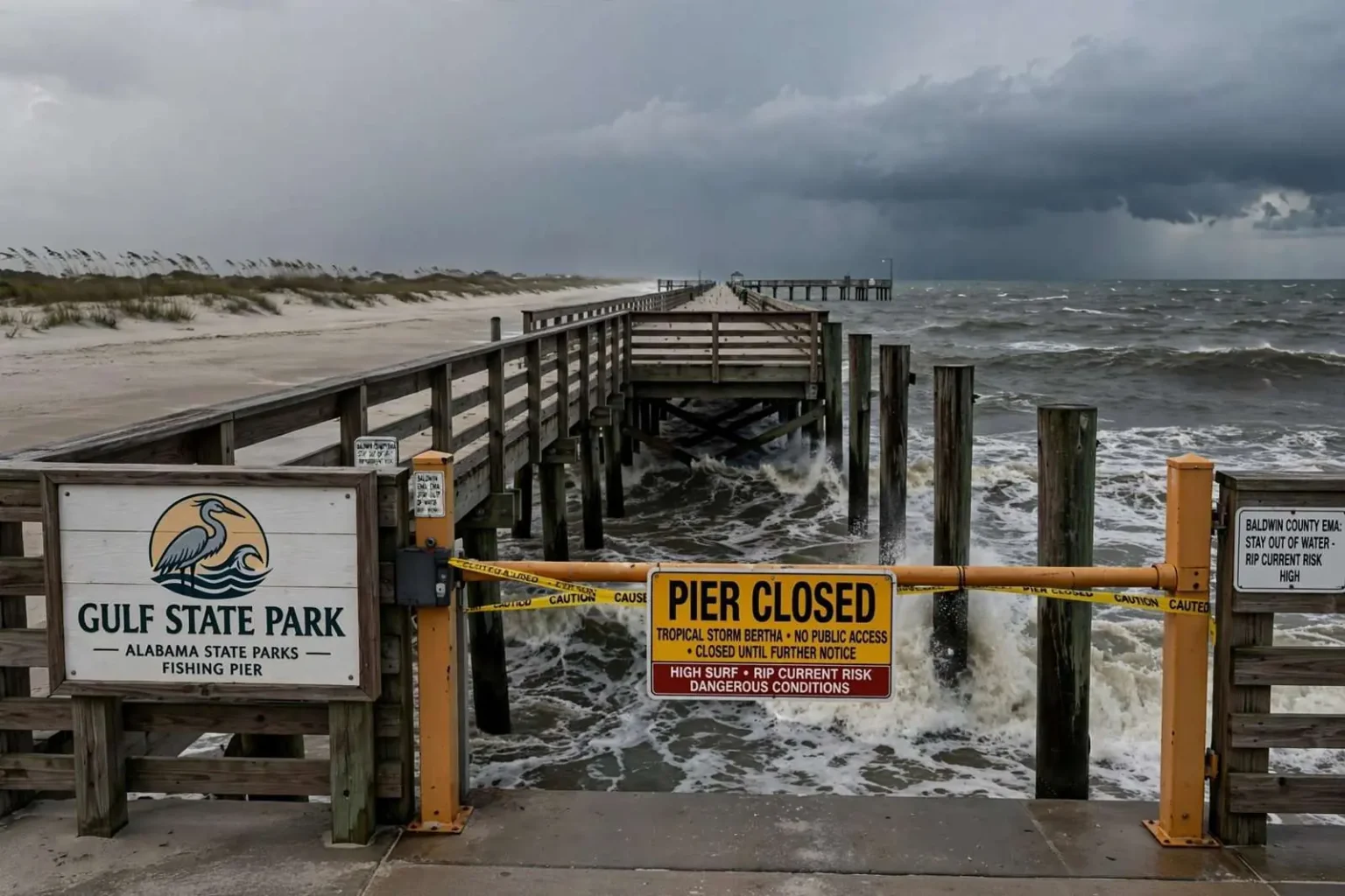
Gulf State Park closed its fishing pier in Gulf Shores late Monday night as a precaution while Tropical Storm Bertha churned in the Gulf of Mexico, stirring up rougher surf and choppier conditions along the Alabama coast.
The closure removed one of the coast’s most visited structures from public access even before the storm’s weather arrived in force, a timing that reflects how tropical systems announce themselves at the shoreline. Long before the rain bands and peak winds reach a community, the surf out ahead of a storm begins to change, and officials along the Alabama coast have learned to move early rather than react late.
By early Tuesday, the scene along the shoreline near the pier was a study in contrast: strong wind and building waves working against an otherwise quiet, largely empty stretch of beach. No rain had reached the immediate coast yet, but conditions were expected to deteriorate as the storm continued its slow track through the northeastern Gulf.
Gulf State Park stretches across miles of protected beachfront at the heart of Alabama’s coastal tourism corridor, and its pier draws visitors throughout the year regardless of season. The park’s campgrounds, trails and beach pavilions make it the anchor of public access along the stretch of coast, which means any closure there registers immediately with residents and visitors alike.
The warnings and the forecast
Baldwin County Emergency Management Agency officials said they were continuing to monitor the situation closely even though the bulk of the storm remained offshore. Monitoring is the standing posture of coastal emergency management during tropical season, with officials tracking forecast updates, tide data and observations from the shoreline to stay ahead of changes in a storm’s track and intensity.
The pier closure came as Bertha carried a Tropical Storm Warning for southern and central Mobile and Baldwin counties, with forecasters tracking a high risk of rip currents and warning that surf could build to as much as 8 to 11 feet at the height of the storm.
Surf of that height transforms the nearshore environment along the Alabama coast, where the generally gentle bottom slope and modest normal wave heights mean most residents rarely see conditions of that kind. Waves of 8 to 11 feet overtop sandbars, tear at dune lines and push water across low-lying beach access points, reshaping the beach itself in the process.
Those conditions, combined with gusty winds along the immediate coastline, made structures like the Gulf State Park Pier one of the first places officials moved to close as the storm approached.
The pier extends far out into the Gulf, giving anglers access to deeper water without a boat and offering walkers a vantage point over the coastline that no beach spot can match. Its popularity makes it a bellwether for the park itself: when the pier closes, regulars know the weather has turned serious, and when it reopens, the coast is open for business again.
Gulf Shores and the neighboring beach communities depend heavily on visitors, and tropical season brings an annual rhythm of closures, advisories and reopenings that tourism businesses plan around. Early-season storms like this one arrive while summer crowds are still building, which adds urgency to the messaging that officials push out about beach safety.
Why the pier closes before anything else
The pier is one of the most popular attractions at Gulf State Park, drawing anglers and sightseers year-round for its long reach out over the Gulf. It is also one of the more exposed structures on the coast during a tropical system, since pilings, railings and decking can take a beating from wind-driven waves and storm surge even when a storm’s center stays well offshore.
Closing the pier ahead of the roughest conditions is a standard precaution meant to keep visitors away from a structure that becomes especially dangerous when waves are breaking beneath and around it. The pier’s elevation puts visitors directly in the environment where wind-driven spray and wave action concentrate, and a fall or a wash across the deck in those conditions can quickly become a life-threatening situation.
The pier’s history includes tropical weather. The structure was rebuilt after Hurricane Ivan damaged it in 2004, and the rebuilt pier that reopened later in the decade was designed to better withstand the Gulf’s storms. Even so, park officials treat each tropical system as a test, closing the pier when conditions warrant and inspecting it before reopening.
Pier closures also protect the anglers and sightseers who otherwise might attempt to visit. A closed gate removes the decision from the individual, and park staff have long practiced the closure as the first step in any storm preparation at the park, ahead of the broader work of securing pavilions, restrooms and equipment across the facility.
Rip currents and the beach hazard
The high risk of rip currents flagged by forecasters is among the most dangerous features of a tropical system’s approach, and it extends well beyond the pier itself. Rip currents are narrow channels of water flowing away from the beach that can pull even strong swimmers offshore, and they form and move along the beach as wave energy changes.
Swimming advisories and beach warning flags communicate the risk to visitors, and the flags fly at lifeguard stands and access points along the coast. A single red flag signals high hazard, while double red flags close the water entirely, and officials along the Alabama coast rely on the system to keep beachgoers out of the surf when conditions turn dangerous.
Even beachgoers who never enter the water face risks in building surf, from shore break that can knock adults off their feet to waves reaching the base of dunes and seawalls. Emergency managers along the Gulf Coast consistently urge visitors to stay well back from the waterline as a storm approaches, no matter how inviting the beach may look under clearing skies between rain bands.
Officials said they expected conditions to remain rough through the middle of the week before gradually improving as Bertha tracked farther west, away from the Alabama coast. That improving trend would come only after the worst conditions passed, and emergency managers planned to keep restrictions in place until the surf subsided and inspections could be completed.
Rip currents claim lives along the Gulf Coast every year, and tropical systems are a leading contributor because they generate the wave energy that forms them while drawing beachgoers who may not realize the danger. Safety officials hammer the same advice in every storm: if caught in a rip current, stay calm, swim parallel to the shore to escape the current, and signal for help rather than fighting the water directly.
The flag warning system only works when visitors pay attention to it, and emergency managers along the coast spend considerable effort on public education, particularly for the many tourists who arrive from inland areas where beach hazards are unfamiliar. Signs at beach access points, hotel messaging and social media updates all carry the flag status during storm events like this one.
What emergency officials were watching
In the meantime, Baldwin County EMA urged beachgoers to stay out of the water and away from the surf zone while the storm passed, echoing the guidance that coastal emergency managers issue with every tropical approach. The agency’s monitoring covers not just the immediate forecast but the practical conditions on the ground, from beach erosion to the status of public access points along the county’s shoreline.
Emergency management officials along the coast coordinate with park staff, municipal governments and the National Weather Service office that serves the region, sharing observations that feed into decisions about closures and public messaging. The coordination matters most in the hours before a storm’s effects peak, when conditions can change quickly and the public depends on timely, consistent guidance.
Tropical systems entering the northeastern Gulf put the entire northern Gulf Coast on alert, since forecast uncertainty at that stage means communities from Louisiana to the Florida Panhandle watch the same storm with interest. For the Alabama coast, a storm churning offshore brings days of elevated surf and gusty winds even when the center never makes a direct approach, and the beach community plans around that reality every hurricane season.
When will things return to normal
The reopening of the pier and the resumption of normal beach activity depend on the surf subsiding and park staff completing inspections of the structure and the surrounding beach. Pier inspections after rough seas check the decking, railings and structural elements for damage, and reopening follows only when officials are satisfied the structure is safe for the anglers and visitors who crowd it in fair weather.
For now, the closed gates at the pier stand as the most visible sign of a storm that had yet to bring rain to the coast but had already changed the rhythm of life along the beach. Residents and visitors along the Alabama coast know the drill by now, and the days ahead will belong to high surf, gusty winds and the slow return of calmer Gulf waters as Bertha moves on.
The state park’s staff also use storm events to prepare the rest of the facility, securing loose equipment, checking drainage and preparing campgrounds for the possibility that conditions worsen. Campers with reservations during a tropical weather event are typically notified of changing conditions, and the park’s management has refined its storm procedures through repeated experiences with Gulf systems over the years.
Along the coast, the response to a storm like Bertha follows a familiar sequence: closures first, then the peak of the weather, then assessments and reopenings. Each step is unhurried by design, because officials know that the cleanup after a storm routinely injures more people than the storm itself, particularly when downed limbs, damaged structures and lingering surf are involved.