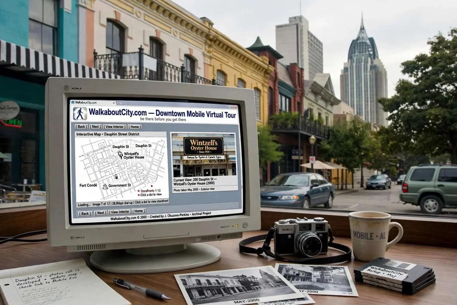
Long before Google Street View, an independent website called WalkaboutCity.com set out to let visitors “be there before you get there” in downtown Mobile, quietly building one of the earliest block-by-block virtual tours of the city’s core. The project predates the mapping tools most people now take for granted by years, assembling photographs, interactive maps and storefront views into something that functioned less like a website and more like a walking tour frozen in time. Two decades later, what began as a promotional curiosity has taken on a second life as a historical record of downtown Mobile at a pivotal moment in its modern history.
The site, created around the turn of the millennium by then-Mobile resident Joann Okuzono-Perkins, focused most of its attention on Lower Dauphin Street but also let visitors browse other downtown blocks and, in some cases, step inside individual businesses through interior photos. The emphasis on Dauphin Street was no accident: the corridor was then the centerpiece of downtown’s entertainment and nightlife district, and the blocks between the waterfront and the city’s historic neighborhoods were where the city’s revitalization hopes were most visibly on display. By photographing storefronts door by door and stitching them to clickable maps, the site offered a granular view of the streetscape that few official publications attempted.
It was an ambitious undertaking for the era: interactive maps that let users click their way up and down city blocks at street level, at a time when most residential internet connections were still measured in kilobits per second. Loading a handful of photographs could take the better part of a minute on a dial-up modem, and video was impractical for most audiences. Yet the site’s approach anticipated features that later became standard in consumer mapping products — the ability to stand on a virtual sidewalk, look up and down the block, and step into a business — and it did so years before tech companies photographed America’s streets with camera-equipped cars.
A Record of the ‘String of Pearls’ Era
The tour arrived during what locals came to call downtown Mobile’s “String of Pearls” period, a stretch of the late 1990s and early 2000s when a cluster of restaurants, shops and entertainment venues anchored the blocks around Dauphin Street and Fort Condé. The nickname reflected the idea that each successful business was a pearl on a string, and that together they could draw visitors downtown the way a single destination never could. Civic leaders embraced the concept as a strategy for reviving a central business district that had emptied out in the evenings for decades as residents and retailers moved to the suburbs.
Meta-data and archived pages from the site reference businesses such as Wintzell’s Oyster House, the Original Oyster House, and other dining and retail spots that defined the district at the time, alongside civic landmarks like the Mobile Zoo and points along Government Street. Wintzell’s, a downtown institution known for its shelves of comedic signs and its Gulf oysters, had already been serving Mobile for generations by the time the tour documented it, while the Original Oyster House drew diners from across the bay area. Their inclusion alongside attractions like the Mobile Zoo shows how the site blended the city’s dining culture with its broader Gulf Coast identity.
Fort Condé itself, a reconstructed French colonial fort anchoring the foot of the downtown district, gave the area a historical backdrop that few Southern cities could match. The reconstruction, opened in the 1970s after portions of the original fort were unearthed during urban renewal, had become the symbolic gateway to the historic district, and its presence in the tour’s maps placed the surrounding businesses in the context of the city’s three-century story. Government Street, meanwhile, tied the district to the grand antebellum and Victorian homes for which Mobile is known.
Because the project documented storefronts and interiors as they actually existed at that moment, it inadvertently became something more valuable with time: a preserved record of a downtown business landscape that has since changed considerably. Several of the establishments captured in the tour have since closed or been replaced, making the site a useful, if accidental, historical archive. Where official histories tend to record opening dates and building architecture, the tour recorded mundane details — signage, menus, paint colors, interior layouts — that are precisely the things historians of everyday life most often lose.
That kind of documentation has become only more precious as downtown has continued to evolve. Businesses that were fixtures of the String of Pearls era gave way to newer restaurants, bars and residential conversions as Mobile invested in its waterfront, its museums and its festival economy. For anyone trying to understand what downtown felt like at the turn of the millennium — not just what it looked like from above, but what a visitor encountered at eye level — the archived pages are among the few remaining windows.
Why It Still Matters
Amateur, independently built projects like WalkaboutCity.com rarely set out to be historical documents. They are usually built to promote, to share, or simply to satisfy the curiosity of their creators, and they are frequently lost when hosting bills go unpaid or software becomes obsolete. The web is notoriously bad at remembering itself; studies of early web content have found that large fractions of pages from the 1990s have vanished entirely. That this Mobile project survived in archived form is the exception, not the rule.
But two decades on, this one offers a rare street-level view of downtown Mobile from a period when the city’s revitalization was still taking shape, giving historians, urban planners and curious residents a way to compare what downtown looked like then against what stands there now. Planners studying how entertainment districts grow can trace which storefronts changed hands and which endured. Preservationists can use interior photographs to document how historic building interiors were configured before renovations. And former residents who moved away can take a virtual stroll through the city they remember.
The project is also a reminder of how much the web has changed. In the era WalkaboutCity.com was built, a determined individual with a camera, a scanner and basic HTML skills could produce something genuinely useful without institutional backing. The independent web of that period was full of such efforts — hometown virtual tours, local history pages, fan-maintained guides — created by people who simply knew their communities well. Many have disappeared, but the best of them captured their places with an intimacy that no corporate mapping product has replicated.
For Mobile specifically, the archive captures the city at a hinge point. The late 1990s and early 2000s brought the completion of major downtown investments, a renewed push around Mardi Gras tourism, and the gradual return of nightlife to Dauphin Street after decades of decline. The tour shows the district in the middle of that transition — neither the struggling downtown of the early 1990s nor the busier, more polished district that would emerge later, but the moment when a handful of businesses were proving that people would come back.
The story also underscores the fragility of digital history. Photographs of buildings survive in libraries and archives, but photographs of websites — with their maps, captions and links — survive only when someone thinks to preserve them. Web archiving efforts by national institutions and university libraries have rescued portions of the early web, and projects like WalkaboutCity.com benefit when their pages are captured before they disappear. Locals interested in the city’s recent past have reason to be grateful to whichever archivists thought a virtual tour of Mobile was worth saving.
The technology behind the tour also tells a story about how local information used to travel. In 2000, a traveler planning a trip to Mobile might have relied on printed guidebooks, the convention and visitors bureau, or a phone call to a chamber of commerce. A virtual tour that let them see an actual block of Dauphin Street — the awnings, the neighboring storefronts, the walk from a parking spot to a front door — offered a kind of reassurance those sources could not. It answered the small questions that decide whether a visitor feels comfortable exploring an unfamiliar downtown: where things are, how close together they sit, and what the street itself looks like.
In the end, the site’s slogan turned out to be truer than its creator could have known. WalkaboutCity.com promised to let visitors be there before they got there; two decades later, it lets visitors be there after the place itself has changed. For a city that has remade much of its downtown in the years since, that accidental time capsule — one person’s block-by-block portrait of Mobile around 2000 — has quietly become one of the most vivid records of how far the city has come.
The site’s method — walking a street and photographing every storefront — has since been industrialized, but the hand-built version has qualities the automated one lacks. A corporate mapping car captures a single pass on a single day, often with camera glare and stitching artifacts. A local creator chooses what to include, revisits businesses, and documents interiors that no street-level camera can reach. That selectiveness makes the archive feel less like a survey and more like a guided walk, and it explains why researchers studying the early web keep returning to projects of this kind.
For Mobile, the lesson is a familiar one in preservation circles: records of ordinary places are usually created by amateurs, and they are usually lost unless someone decides in advance that they matter. Cities keep meticulous records of property transactions and building permits, but the texture of a commercial district — which businesses neighbored which, how a block felt on a Friday night — lives in sources like this one. The archived tour of Lower Dauphin Street is now among the clearest pictures of the String of Pearls era that survives, which makes its preservation worth noting and its existence worth celebrating.