University of South Alabama Daphne
Meteorologist Alan Sealls Explains Why Some Tornadoes Strike Without Warning
Mobile meteorologist Alan Sealls explains why the National Weather Service could warn residents about the May 6 tornado that struck Daphne but not the one that hit Mobile minutes earlier, and what that gap reveals about the limits of tornado forecasting.
One Minute, No Warning
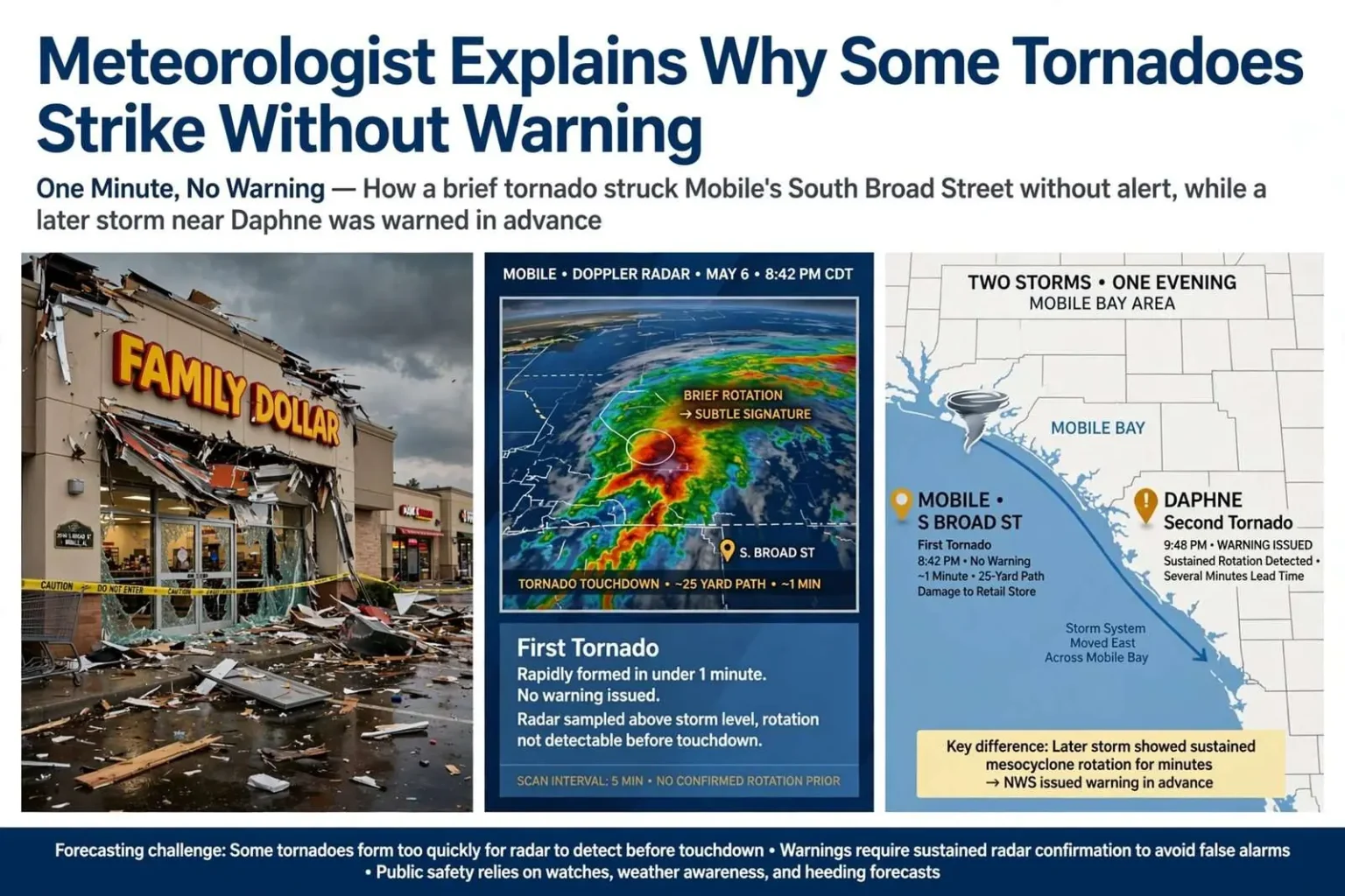
The tornado that tore through a Family Dollar store on South Broad Street in Mobile on May 6 struck without any advance warning from the National Weather Service, and local meteorologist Alan Sealls says that gap is not a failure of technology so much as a reminder of how quickly and quietly some tornadoes can form.
The Mobile twister lasted about one minute and carved a path roughly 25 yards wide. No injuries were reported, but the storm caused significant damage to the retail building. It was the first tornado of the night, spinning up rapidly from a thunderstorm that gave forecasters only a brief and subtle signature on radar before it touched down.
A tornado with a one-minute lifespan and a 25-yard path is the kind that does the most to confound forecasting. It exists too briefly to track, forms too quickly to warn against, and can drop in a developed commercial corridor, like the South Broad Street retail strip, where minutes matter because people are present in numbers. The damage to the store showed what even a small tornado can do to an unreinforced retail structure, and the absence of injuries in this case owed as much to luck and timing as to any warning.
Later that same evening, a second tornado developed as a storm crossed Mobile Bay and moved into Daphne. That storm displayed a clearer, more sustained rotation signature for several minutes before producing a tornado, giving the National Weather Service enough lead time to issue a warning ahead of impact.
The difference between the two storms illustrates a challenge that meteorologists face every severe weather season: no two tornado-producing storms behave exactly alike, and the atmospheric conditions that determine when a rotating thunderstorm actually drops a tornado can vary from one storm to the next, even within the same weather system on the same night.
That point deserves emphasis for anyone who follows severe weather coverage. A single squall line crossing Mobile Bay can produce one tornado with almost no radar signature and another with a textbook rotating mesocyclone minutes later. The atmosphere, not the forecast process, decided which storm announced itself, and the same event can therefore be both a forecast success and a forecast miss within an hour.
Why Radar Cannot Catch Everything
Sealls, who serves as chief meteorologist for a Mobile television station and also teaches as an adjunct meteorology professor at the University of South Alabama, has fielded frustrated questions from residents who could not understand how a warning was possible for the Daphne tornado but not for the one in Mobile. He said the honest answer is that forecasters and radar technology cannot catch every tornado before it forms, particularly the first one in a developing severe weather event.
Meteorologists rely on Doppler radar to detect rotation within thunderstorms, but that rotation does not always appear clearly enough, early enough, to support a warning before a tornado actually touches down. A storm can intensify and spin up a brief, small tornado faster than the radar signature develops into something unmistakable.
Doppler radar works by measuring motion inside a storm, and the rotation that produces a tornado shows up as a couplet of winds moving toward and away from the radar site. But the beam samples the storm at increasing height the farther the storm sits from the antenna, and the lowest, most important part of the storm can hide below the beam entirely. A storm that spins up a tornado in under a minute may complete the entire process between radar scans, which is why the Mobile tornado produced only a brief and subtle signature before impact.
Once a storm has already produced one tornado or shown sustained rotation, forecasters have a better basis for anticipating additional tornadoes from that same storm or storm mode. That is precisely what happened as the evening progressed: the first tornado gave forecasters a storm to watch, and when it crossed Mobile Bay with a sustained, unmistakable rotation signature, the warning for Daphne went out before the tornado formed.
The Warning Threshold Trade-Off
Issuing a warning for every disturbance with even a slight chance of becoming a tornado would come with its own costs, according to Sealls. A dramatically lower threshold for warnings would mean many more false alarms, and residents would be more likely to tune out warnings altogether if they came too often without a tornado materializing. Weather officials have to strike a balance between warning early enough to protect the public and maintaining public trust by keeping false alarms manageable.
The trade-off is one of the least understood aspects of warning meteorology. A warning that is always issued, for every rotating storm and every radar blip, stops protecting anyone, because the public’s response to warnings erodes with every false alarm. Forecasters weigh the probability of a tornado, the population in its path and the credibility cost of crying wolf, and the balance they strike means that some brief tornadoes, like the South Broad Street twister, will touch down before any warning can responsibly be issued.
For residents, the practical lesson Sealls draws is that a warning is only one layer of protection. On nights when severe weather is forecast, the forecast itself, watch conditions and general storm expectations carry the responsibility that individual warnings cannot always deliver, particularly for the first tornado of an event.
Social Media and the Language of Forecasts
That same balancing act carries into hurricane season, which is now getting underway along the Gulf Coast. Long-range tropical outlooks and forecast graphics circulate widely on social media, often stripped of the nuance and caveats that came with them.
Sealls urges residents to pay close attention to the specific language used in forecasts, noting that words like “could,” “might” and “may” describe possibilities, not certainties, and are very different from “likely” or “will happen.”
The distinction matters most when a graphic is shared without its original context. A map showing a possible storm track hundreds of miles wide, produced by a forecast model as one scenario among dozens, can circulate as if it were a confident prediction, and by the time it reaches a family deciding whether to prepare, the probabilities embedded in the original forecast have hardened into something that looks like a certainty.
Social media algorithms tend to boost posts that generate strong reactions or that look dramatic, regardless of their accuracy, which can distort public perception of an approaching storm’s actual threat.
Sealls said no amount of online speculation changes what the atmosphere is actually going to do, and he encourages residents to maintain a realistic understanding of the limits of forecasting science and computer models.
The incentive structure of social media runs directly against the caution that good forecasting requires. A dramatic map, an alarming headline or a worst-case scenario graphic will always travel faster than the measured explanation of what the models actually show, and during a hurricane threat, that dynamic can leave residents more frightened or less prepared than the real forecast warrants. Sealls’ advice points residents back to the sources that carry the caveats along with the conclusions.
The Limits of Two-Week Forecasts
Longer-range forecasts, including 14-day models, are also a frequent source of confusion. A model run two weeks out can look every bit as detailed and confident as one showing tomorrow’s weather, but its accuracy drops considerably the further out it projects.
Sealls suggests that anyone tempted to treat a two-week forecast as fact save the graphic and revisit it once that day actually arrives to see how closely it matched reality.
The exercise is a reliable corrective, because the atmosphere is a chaotic system in which small errors in the initial observation of wind, temperature and moisture compound with every day of projection. By two weeks out, a model run can show a detailed, confident-looking forecast for a day that bears little resemblance to what actually happens, and the same model run a week later will show something different for the same day. Model graphics look authoritative by design, but their skill declines with distance in a way that no amount of visual detail can overcome.
Probability, Not Fact
Ultimately, forecasters can speak with certainty only about the past and the present, according to Sealls, while anything involving the future is a matter of probability rather than fact.
That distinction, he said, is easy to lose sight of amid the volume of weather content shared online, but it remains central to understanding both the successes and the limitations of modern forecasting.
For Gulf Coast residents, the framework has practical value through every season. In tornado season, it means understanding that a night like May 6, when one tornado arrived unannounced and another was warned in advance, is not a contradiction but a demonstration of how the atmosphere works. In hurricane season, it means treating a seven-day forecast cone as an estimate that will be refined, not a schedule that will be kept, and waiting for the forecast to sharpen before drawing conclusions about impacts.
The lesson Sealls draws from both the tornado and the social media storms around it is consistent: the public’s trust in forecasting is best served by understanding what forecasts can and cannot do. Radar and models have improved to the point that most dangerous weather is detected early, but the atmosphere retains the ability to surprise, and a forecaster’s credibility depends on saying so plainly, in words that distinguish what might happen from what will.
Between the store on South Broad Street and the coast-wide attention hurricane season will bring, Mobile’s weather community will have plenty of opportunities to apply that standard. The residents who understand the difference between possibility and certainty, and between a model graphic and a forecast, will be the ones best prepared for whatever the atmosphere decides to do.