Mobile Launches Tethered Drone Program to Boost Public Safety at Parks, Events
Mobile's Department of Public Safety has launched a tethered drone program using Fotokite technology to monitor city parks and large public events in real.
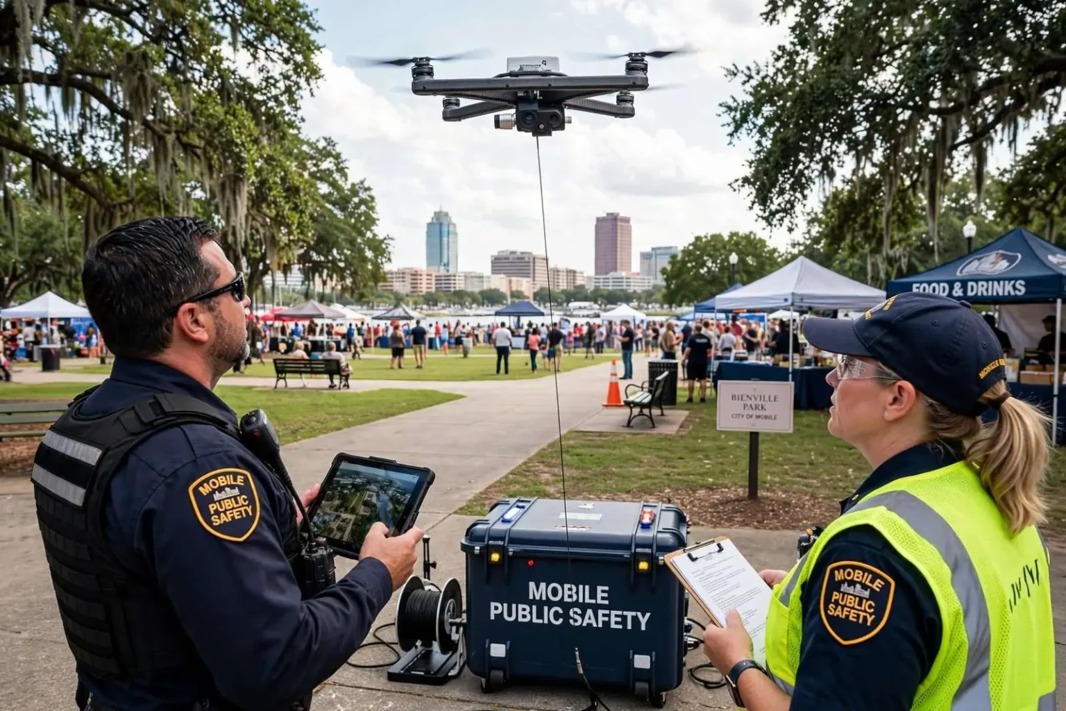
MOBILE, Ala. — The city of Mobile has launched a tethered drone program aimed at improving public safety at city parks and large events, using a system that keeps a drone connected to a ground station for extended, real-time aerial monitoring.
The Fotokite-based “aerial situational awareness” program, which the city says began in May, follows research by the Gulf Coast Technology Center into drone technology capable of providing livestream safety overwatch of popular areas and events.
The distinction between a tethered drone and the free-flying drones most people picture is the heart of the program. A tethered system remains physically connected to a powered ground station by a line that carries both data and electricity, allowing continuous flight for hours at a fixed vantage point — no battery swaps, no landing rotations, no pilot losing sight of the aircraft. For monitoring a park on a summer Saturday or a parade route on a holiday weekend, that endurance changes the calculus: the city gains a persistent overhead camera rather than a drone that must land every 20 or 30 minutes.
The tether also simplifies the regulatory picture that has complicated drone programs in cities across the country. Free-flying drones in populated areas raise FAA operational restrictions and public-safety concerns, while a drone anchored to a ground station at a fixed point presents a different risk profile — one that manufacturers of tethered systems have built their market around. For a city that wants regular, dependable aerial coverage without an aviation operation, the tethered approach offers a middle path.
What Officials Say the System Will Do
Mobile Director of Public Safety Curtis Graves said the system “isn’t meant to invade anyone’s privacy,” adding: “Instead, it gives our first responders an additional tool to assess large events in real-time and the ability to monitor parks and other areas while aggressively pursuing our public safety efforts.”
Graves’ remarks address the concern that follows every municipal drone program: what the cameras see, who watches the footage, and how long it is kept. Municipal drone deployments nationwide have drawn scrutiny from privacy advocates who worry that aerial surveillance creeps from event monitoring into routine tracking of everyday residents. By framing the system as a first-response tool — activated for events and public-safety purposes rather than standing watch over daily life — city officials are positioning the program on the accepted side of that line.
Officials say the tethered system is expected to improve emergency response times and increase incident command visibility. Both claims rest on the same operational reality: a live aerial view compresses the time it takes for commanders to understand what is happening on the ground. When a fight breaks out in a festival crowd, a medical emergency occurs in a crowded park, or traffic snarls around an event, an overhead livestream lets incident commanders direct resources to the exact spot rather than relying on radio reports and officers’ descriptions to reconstruct the scene.
The Mayor’s Case for the Program
Mayor Spiro Cheriogotis said the technology will be especially useful given the number of large events held in Mobile throughout the year.
“Drones have proven to be useful tools for agencies around the country, especially where big crowds are present,” Cheriogotis said. “This is a cost-effective way to enhance what we’re already doing to help keep the public safe.”
The mayor’s reference to Mobile’s event calendar is understated. The city stages and hosts an unusually dense schedule of mass gatherings for its size: the Mardi Gras season, which fills downtown streets with parade crowds for weeks each winter; the Senior Bowl and its week of activities each January; festivals, concerts, and celebration events in parks across the city; and the steady calendar of runnings, rides, and gatherings that use the city’s public spaces. Each event strains public-safety staffing in its own way, and each represents a scenario where one elevated viewpoint can do the work of several additional officers on the ground.
The cost argument in the mayor’s remarks carries equal weight. Police staffing scales with crowds, and overtime for major events is a recurring budget line that grows with the city’s event calendar. Aerial monitoring offers a force multiplier: a single tethered unit with a live feed can give commanders coverage of an area that would otherwise require multiple observation posts or a helicopter — an asset whose hourly operating cost dwarfs that of a tethered drone system. For cities managing tight budgets, the economics are frequently the deciding argument.
How Tethered Systems Work in Practice
In the field, a tethered drone deployment looks more like setting up a mobile light tower than launching an aircraft. The ground station is positioned at a command point near the area to be monitored, the drone rises to its operating altitude on its tether, and it holds station there, streaming video to operators below. The Fotokite systems used by public-safety agencies are designed for rapid setup by personnel without specialized piloting credentials, with the tether itself providing unlimited flight duration as long as ground power holds.
The live feed integrates with incident command. At a large event, the video stream can be routed to a command post where supervisors watch crowd density, spot disturbances as they form, and track the movement of emergency vehicles through congested areas. That visibility supports decisions in real time — when to close a gate, where to send the next medic unit, how to reroute pedestrian flow — with a precision that ground-level observation cannot match.
Weather and lighting are practical considerations. Tethered systems are built to operate in wind and rain that would challenge conventional drones, but severe Gulf Coast weather — summer thunderstorms, tropical systems — remains a limiting factor, as it does for all outdoor technology. Nighttime operation, aided by stabilized cameras and low-light sensors, extends the coverage window through the evening hours when many Mobile events reach their peak.
The Research Behind the Launch
The program’s origins trace to research by the Gulf Coast Technology Center, which examined drone technology capable of providing livestream safety overwatch of popular areas and events. That research phase — evaluating what the technology could do, which systems met public-safety requirements, and how deployment would fit the city’s operations — reflects the way successful municipal technology adoptions begin: with study before procurement rather than the reverse. The center’s work gave the city’s decision a foundation in tested capability rather than vendor enthusiasm.
Mobile’s investment in technology-centered public safety research fits the city’s broader economic identity. The Gulf Coast region has spent two decades building a technology and aerospace footprint, from the Airbus assembly line at Brookley Aeroplex to the engineering programs at the University of South Alabama, and city government has increasingly looked to that homegrown expertise when modernizing its own operations. A public-safety drone program researched locally and deployed locally keeps the circle of that investment intact.
Parks, Events, and What Comes Next
City officials say the tethered drones will supplement Mobile’s existing citywide park surveillance camera program going forward. That existing network of fixed cameras already gives police coverage of park grounds, playgrounds, and parking areas across the city; the drones add the dimension the fixed cameras lack — a view that moves, elevates, and deploys wherever an event or incident makes it useful. The combination, officials suggest, is a layered system: fixed cameras for routine coverage, tethered drones for dynamic and elevated coverage on demand.
For park users, the practical experience of the program should be unobtrusive. A tethered drone operating over a special event or during a public-safety deployment draws less attention than a helicopter and covers a smaller footprint than residents might imagine; its purpose is situational awareness for responders, not continuous observation of individuals. Officials have framed the privacy question as settled policy — the system exists for events and public-safety operations — and the program’s credibility will rest on the city operating it that way.
The launch in May places Mobile among a growing roster of American cities experimenting with tethered aerial systems for public safety, a list that spans agencies using the technology for crowd monitoring, disaster response, and downtown patrol support. As the program matures, its results in Mobile will be measured the way public-safety technology always is: in response times, in incidents spotted early, and in the large events that stay safe from opening to closing. For a city whose calendar is defined by big crowds, the tethered drone program gives Mobile’s first responders one more set of eyes overhead — anchored, persistent, and watching the whole scene at once.
That measurement will unfold across the city’s public spaces in the seasons ahead. If the program performs as officials expect, the quiet success will look like nothing at all: crowds that flow safely through festival weekends, emergencies met by responders who already knew what they were driving into, and parks where families notice the technology only when it is pointed at a problem. The tethered drones are, in the end, a modest addition to a public-safety apparatus the city has built over decades — one more tool, held steady overhead, doing exactly the job its designers intended.