No downed helicopter in Pascagoula River; marsh fire was the cause
Jackson County officials determined a reported helicopter down in the Pascagoula River was actually a marsh fire north of Interstate 10.
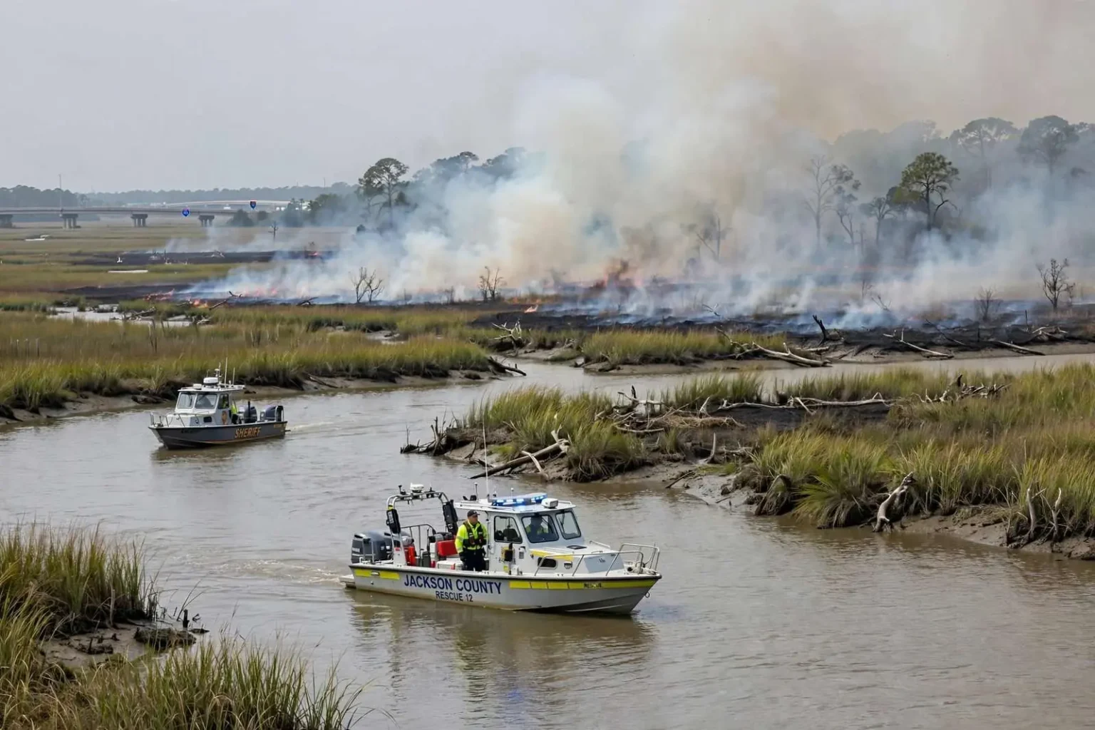
There was no downed helicopter in the Pascagoula River. That was the determination by authorities in Jackson County, Mississippi, after emergency crews spent the day chasing reports of a possible aircraft crash — reports that turned out to be smoke from a marsh fire burning north of Interstate 10.
The Jackson County Emergency Operations Center said the blaze reported north of Interstate 10 was a marsh fire, not a helicopter crash. Earlier in the day, emergency crews had mobilized boats to search the river after unconfirmed reports that a helicopter had gone down in the water, and the exact location of the reported incident was unknown as responders arrived, forcing them to sweep a wide stretch of the river and its surrounding wetlands.
How the false alarm unfolded
Reports of smoke rising from the marshlands along the Pascagoula River spread quickly, and somewhere between the first sightings and the calls to 911, the smoke became a possible helicopter crash. It is a familiar pattern along the Gulf Coast: heavy gray smoke over water can look, at a distance and in a hurry, like an aircraft in distress, and witnesses acting in good faith pass along what they think they saw. Dispatchers are required to treat such reports as real until proven otherwise.
That is exactly what happened. Boats were mobilized to search the river, and responders worked an area where the exact reported location was uncertain — no small task on a waterway as broad and braided as the Pascagoula River, which winds through miles of marsh, oxbows and side channels north and south of Interstate 10 before emptying into the Mississippi Sound. Searchers had to cover the likely spots methodically while fire crews worked to reach the smoke’s source on the ground.
The Jackson County Emergency Operations Center eventually sorted it out. The smoke, officials confirmed, was coming from a marsh fire burning north of Interstate 10 — a fire in the wetland vegetation rather than any aircraft down. Once that determination was made, the boat search could stand down, and the EOC shifted its public messaging from crash response to fire information.
Why marsh fires fool the eye
Marsh fires are a regular feature of Gulf Coast wetlands, especially during dry spells when the grasses, reeds and organic muck that make up a marsh dry out enough to burn. Fire can creep through a marsh for hours or days, sometimes smoldering underground in peat and root systems before flaring up again, and the smoke it produces is often thick, white-gray and voluminous — precisely the kind of plume that reads as a crash or structural fire from several miles away.
Along the Pascagoula River system, which includes some of the most extensive tidal marsh on the Mississippi coast, the conditions for such fires come together in late spring and summer dry periods. Lightning, debris burning that escapes, equipment sparks and other human causes can all ignite the vegetation. Firefighting a marsh is its own challenge: heavy trucks cannot reach the burning ground, and crews rely on airboats, shallow-draft vessels and natural breaks in the vegetation to contain the burn or simply let it consume its fuel while protecting nearby property.
For residents watching smoke rise over the river, the instinct to report is the right one. Emergency managers across the coast consistently say they would rather respond to ten false alarms than miss one real crash or structure fire. The cost of the error falls on responders, not on the person who called it in, and no agency in the region discourages those calls.
The cost of responding
A report like Wednesday’s draws on real resources. Fire departments from multiple stations respond, sheriff’s deputies assist with access, and marine units from fire, rescue and sometimes volunteer organizations launch boats to search the water. Every hour spent searching a river for wreckage that does not exist is an hour those units are unavailable for other calls, which is why emergency operations centers work quickly to verify or rule out the original report.
The Pascagoula River is a demanding place to search even under the best conditions. It is one of the largest free-flowing river systems in the continental United States, with a delta of marsh and tidal channels that extends for miles. Visibility from the water is limited by the vegetation, and what looks like debris from the air can be driftwood, a discarded boat or a clump of burned marsh grass. Crews searching for a downed aircraft have to check each report carefully, which takes time.
The Emergency Operations Center’s role
The Jackson County Emergency Operations Center sits at the center of incidents like this one, coordinating between fire districts, law enforcement, rescue squads and county government while keeping the public informed. During the helicopter report, the EOC’s most important product was accurate information: confirming that no aircraft was missing, identifying the smoke as a marsh fire north of Interstate 10, and telling residents where the real emergency was and was not.
Officials urged the public to rely on verified information from the Emergency Operations Center as the situation developed, rather than on social media posts and secondhand accounts. That request is a staple of Gulf Coast emergency response, where unverified reports during fast-moving incidents can send volunteers, boaters and curious onlookers toward a scene, adding hazards for both the public and responders. During storms, the same principle applies with even greater force, and Jackson County’s EOC has built its public communication practices around pushing confirmed information out quickly so that rumor has less room to spread.
The EOC’s confirmation also mattered for the fire itself. Once crews knew what they were dealing with, resources could be directed to the marsh fire response — monitoring the burn, protecting structures if any were threatened and informing residents about smoke in their area — instead of a water search.
Marsh fires and the communities around them
Marsh fires in Jackson County can affect more than the wetlands that burn. Smoke drifts with the wind, sometimes reaching neighborhoods in Pascagoula, Moss Point, Gautier and the unincorporated communities north of Interstate 10, and residents with respiratory conditions are typically advised to stay indoors and keep windows closed when heavy smoke is present. The fires can also burn for days in remote wetlands, out of easy reach of equipment, before rain finishes the job.
Ecologically, fire is part of the marsh’s natural cycle. Gulf Coast wetlands evolved with periodic burns, and fire clears accumulated dead vegetation and can improve habitat for the fish, wading birds and other wildlife that depend on the marsh. The problems arise when fire threatens structures, roads or people — and when its smoke mimics something more sinister, as it did in this case.
Mississippi forestry officials regularly remind coastal residents that outdoor burning during dry conditions carries risk, and that a fire set legally on one property can spread into wetlands and become a response problem for several agencies. The vast marshes of the Pascagoula delta are cradled by private land, conservation holdings and public property, so a fire that starts anywhere in the system can move across boundaries quickly.
A familiar lesson for the coast
The episode ended the way most of these incidents do: boats back at their docks, no wreckage found, and a marsh fire added to the day’s log. But the sequence — smoke, a crash report, a water search, and confirmation that the threat was entirely different from what it first appeared — is worth remembering for coastal residents. Smoke over water deserves a 911 call every time. What it means, though, is a question only responders and the Emergency Operations Center can answer, and until they do, verified information from official channels is the only reliable guide.
For Jackson County, the day was a quiet confirmation that its response system works. Reports were taken seriously, boats launched, the EOC verified the facts and the public was told the truth quickly: no downed helicopter, just a marsh fire north of Interstate 10, burning in the wetlands where Gulf Coast fires have burned for centuries.
When to call, and what to say
Emergency dispatchers along the coast offer simple guidance for reports like the one that started the search. Call as soon as the smoke or suspected crash is seen, describe exactly what was observed rather than what it might mean, give the best location possible using roads, waterways or landmarks, and stay available for follow-up questions. A caller who reports “heavy smoke over the marsh north of the interstate” gives responders something they can work with quickly; a caller who only says “a helicopter went down” sends them looking for wreckage that may never have existed.
The distinction matters because response is shaped by the report. A fire call brings fire resources and a wind check; a crash call brings boats, flight checks with aviation authorities and a search pattern. Sorting out which call it really is takes time that responders would rather spend acting on good information, and the public can help by sticking to what they actually saw.
In this case, the system caught up with reality: the marsh fire was identified, the river search ended, and the Emergency Operations Center closed the loop with a clear public message. That is the outcome responders prefer, even on the days when smoke keeps everyone guessing for a few hours.