Sector Mobile Serviced Thousands of Navigation Aids in 2009
A 2009 WKRG report described the Coast Guard's Sector Mobile role in maintaining buoys and other navigation aids.
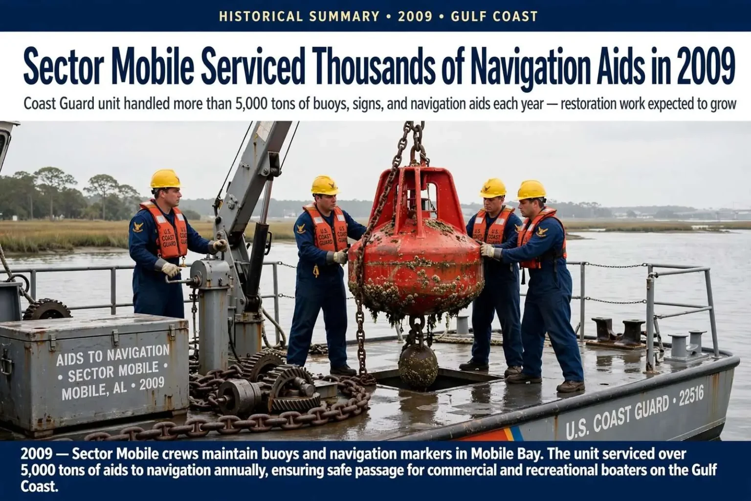
Sector Mobile serviced and built buoys, signs and other navigation aids used by boaters, according to a 2009 local news report. Officials said the unit handled more than 5,000 tons of navigation aids each year and expected restoration work to grow. The report compared the waterway markers to traffic signals and road markings needed for safe travel. This is a historical summary of a 2009 local report.
More than a decade and a half ago, the Coast Guard’s Sector Mobile was carrying out one of the least visible but most essential missions on the Gulf Coast: building, servicing, and maintaining the buoys, signs, dayboards, and other navigation aids that guide boaters through the region’s waterways. According to a 2009 local news report, officials said the unit handled more than 5,000 tons of navigation aids each year, a figure that captures the sheer physical scale of the work — steel buoys hoisted onto decks, chains and sinkers hauled from the bay bottom, and concrete pads and pilings set for fixed signs along the channels.
Officials interviewed at the time said they expected restoration work to grow, reflecting the ongoing demand to rebuild and replace markers damaged by storms, vessel strikes, corrosion, and the passage of time. The report drew a comparison that remains the clearest way to understand the mission: navigation aids are the traffic signals and road markings of the water, and without them, even experienced mariners lose the visual references that make safe travel possible in channels, rivers, and bays.
This article is a historical summary of that 2009 local report, preserved here as a record of the unit’s work and its role in the region’s maritime economy at the time.
What Sector Mobile Does
Sector Mobile, based in Mobile, is a Coast Guard sector that brings together multiple missions under one command for the Gulf Coast region encompassing coastal Alabama and parts of Mississippi and the Florida panhandle. Sectors were established in the mid-2000s to consolidate the formerly separate groups, activities, and marine safety offices into unified commands. From its base on Mobile Bay, Sector Mobile coordinates search and rescue, marine safety and inspections, waterways management, and aids to navigation across one of the busiest maritime regions on the Gulf, an area anchored by the Port of Mobile and threaded with rivers, bayous, and the Intracoastal Waterway.
The aids to navigation mission is among the sector’s most constant responsibilities. Every buoy, beacon, dayboard, and light along the region’s federal channels must be positioned, charted, kept on station, and repaired or replaced when damaged. The Coast Guard shares this work with the U.S. Army Corps of Engineers, which maintains many navigation structures, and with local authorities, but the buoy tender crews that service the federal aids are the visible face of the system for most boaters.
The 2009 report’s figure of more than 5,000 tons handled each year illustrates why the mission requires dedicated vessels and crews rather than occasional attention. Buoys of the kind anchored in Gulf Coast channels can weigh thousands of pounds each, and moving them means cranes, chain, and heavy deck equipment, along with the specialized training to handle all of it safely on a working deck.
The Aids to Navigation System
The markers that Sector Mobile crews service follow the U.S. Aids to Navigation System, the set of conventions that tells a boater where the safe water lies. Red and green buoys and fixed dayboards mark the edges of channels under the lateral system, with the familiar rule that red markers are kept to the right when returning from sea. Yellow special-purpose marks designate security zones, regatta areas, and other features, while regulatory markers with orange symbols warn of hazards or set speed zones. On the Intracoastal Waterway, distinctive yellow squares and triangles overlay the standard marks so that mariners can follow the internal route even where other channel designations intersect it.
The comparison in the 2009 report — navigation aids as the traffic signals and road markings of the water — captures how the system works in daily practice. A recreational boater running the Mobile Ship Channel, a charter captain working Mobile Bay’s oyster areas, or a tug pushing barges up the rivers all rely on the same maintained network. When a buoy is off station or a dayboard is missing after a storm, the risk is not theoretical: channels shift, shoals move, and the water outside the marked line can ground a vessel in minutes.
That is why the unit’s expectation, reported in 2009, that restoration work would grow, tracked with conditions on the water. Storm seasons repeatedly damage the region’s marks, and every restoration cycle requires crews to locate damaged aids, document the damage, and rebuild them to the charted position.
The Waters the Unit Serves
The waterways around Mobile present a demanding environment for navigation aids. Mobile Bay, one of the Gulf’s largest estuaries, receives the flow of the Mobile, Tensaw, Spanish, and other rivers, and the shipping channel through the bay connects the Port of Mobile — consistently among the largest ports in the United States by tonnage — with the Gulf of Mexico. Commercial traffic shares these waters with one of the South’s largest recreational fleets, and the same marks guide both.
Beyond the bay, the region’s marked routes include the rivers that wind north from Mobile, the intracoastal route that crosses Mobile Bay on its way along the Gulf Coast, and the smaller channels serving communities such as Fairhope, Daphne, Gulf Shores, and Orange Beach, along with the Mississippi coastal towns to the west. Each of these waterways has its own hazards: shifting bars at river mouths, oyster reefs and grass flats that rise close to the surface, and the wakes and currents of passing traffic. The signs and buoys maintained by the unit give boaters the fixed references they need to avoid those dangers.
The work also responds to the region’s weather. Hurricanes and tropical systems regularly sweep buoys off station, tear out fixed signs, and scatter debris across channels, and the recovery and restoration that follow a storm are among the busiest periods for aids to navigation crews on the Gulf Coast. The 2009 report’s note that officials expected restoration work to grow fits the pattern the region has seen repeatedly, before and since.
Why the Marks Matter to the Local Economy
The economy of coastal Alabama depends on the water in ways that are easy to overlook. The Port of Alabama’s Gulf trade, the commercial fishing and seafood industries of the bay, the charter fleets of the eastern shore, the shipbuilding and repair yards along the rivers, and the tourism economy of the beaches all rely on safe, charted navigation. Every ferry route, fuel barge, and grain ship moves along the marked channels, and the recreational boaters who fill the bay on weekends follow the same system.
Aids to navigation are also central to the Coast Guard’s search and rescue mission, because accurate, functioning marks reduce the number of vessels that run aground or become disabled in the first place. The comparison made in the 2009 report — traffic signals and road markings for the water — reflects that preventive role. A missing buoy is, in effect, a darkened intersection, and restoring one is cheaper by far than the salvage operation it prevents.
Boaters play a role in keeping the system accurate as well. Federal regulations require mariners to report discrepancies — a buoy off station, a light not flashing, a dayboard damaged — to the Coast Guard, and local knowledge from the boating community often provides the first word that an aid has been damaged. The system works as a partnership between the crews who service the marks and the mariners who use them daily.
The Work Itself
Day to day, servicing navigation aids means heavy, wet, unglamorous labor. Crews lift buoys aboard with cranes, scrape off marine growth, inspect hulls and pockets, replace rusted chain and worn sinkers, verify the aid’s position against its charted location, and lower it back to station. Fixed signs require driving or repairing pilings, mounting dayboards, and checking solar panels and batteries that power the lights. The 5,000 tons a year reported in 2009 represented that labor repeated across hundreds of aids.
The work also demands seamanship of a high order. Buoy tenders operate cranes on heaving decks, hold position over anchors in current, and maneuver heavy loads in tight quarters, often in weather that keeps other vessels at the dock. It is the kind of mission that rarely makes headlines, which is precisely what the 2009 local report corrected by showing readers the work behind the markers they pass every day on the water.
More than fifteen years later, the summary stands as a snapshot of that mission as it existed in 2009: a unit handling more than 5,000 tons of buoys, signs, and navigation aids a year, expecting the restoration workload to grow, and keeping the Gulf Coast’s waterways marked for the boaters, fishermen, and commercial vessels that depend on them.