Severe Storms Bring Hail to Parts of South Alabama
A cold front brought severe weather and hail to Monroe, Clarke, and Escambia counties in South Alabama.
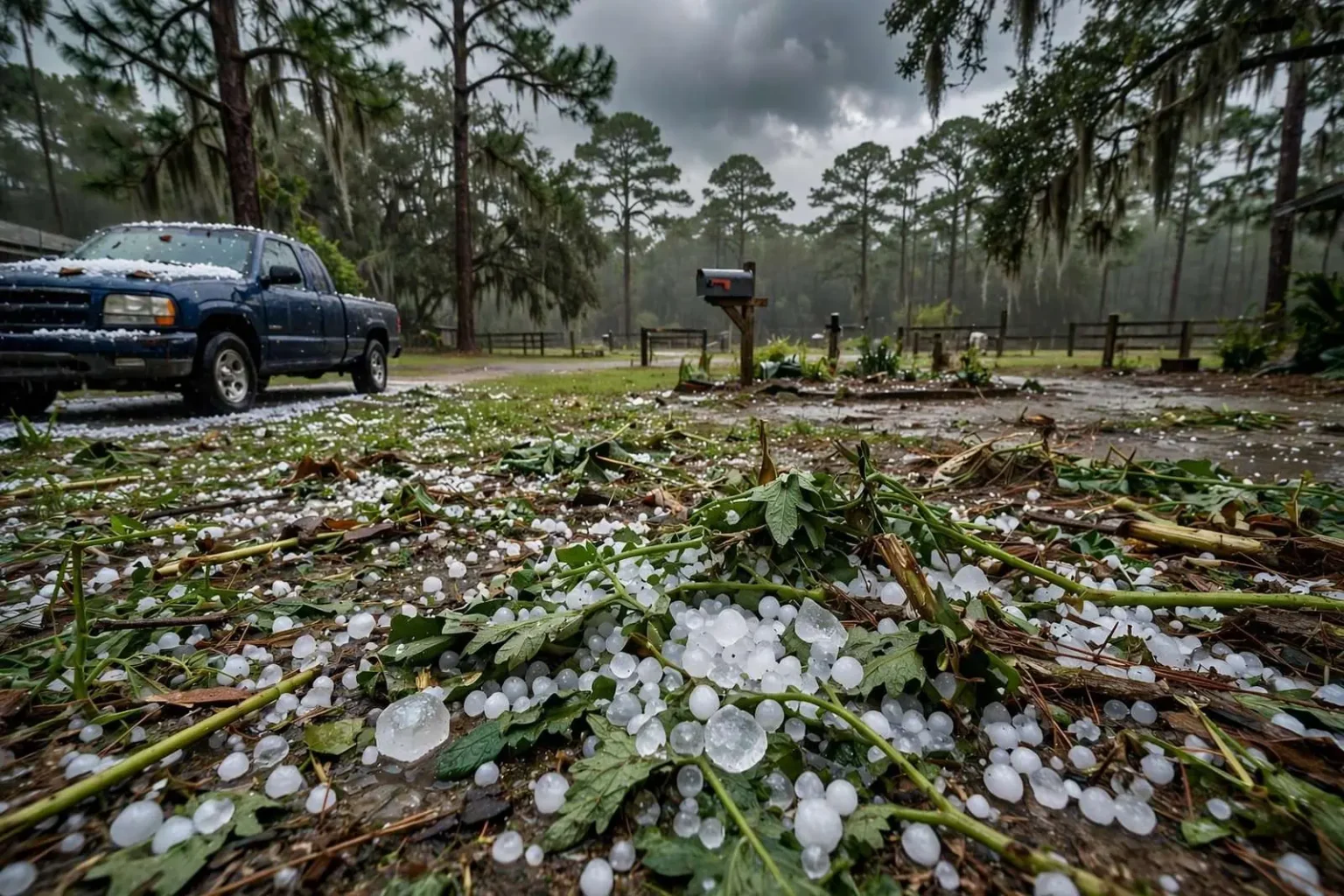
A cold front that passed through Monday evening brought severe weather to parts of South Alabama, including hail in multiple counties. Reports of hail came in from Monroe, Clarke, and Escambia counties as storms fired along and ahead of the front. Hail sizes ranged from dime-sized to quarter-sized stones, large enough to dent vehicle hoods and strip foliage from gardens but generally short of the golf-ball sizes that cause widespread roof damage. The severe weather was part of a cold front that moved through the region Monday evening.
The storms developed as a cold front pushed southeast across the Deep South, colliding with the warm, humid air mass that sits over South Alabama for much of the year. That collision is the classic recipe for spring and fall severe weather in the region, producing lines of thunderstorms capable of damaging wind gusts, frequent lightning, and hail. Monday evening’s round was no exception, with radar showing a broken line of storms sweeping through the coastal plain just as many residents were settling in for the evening.
Hail reports poured in from three counties spread across a wide swath of South Alabama. Monroe County, centered on Monroeville, reported stones measuring roughly dime-sized. Clarke County, with Grove Hill as its seat, saw similar reports as storms crossed the area. Farther south, Escambia County, along the Florida line, reported hail that reached quarter-sized in some locations. The progression of the reports tracked the movement of the front, which marched through the region over several hours Monday evening.
How the Storms Unfolded
As the front approached, forecasters with the National Weather Service office responsible for South Alabama monitored the situation throughout the day, watching for the ingredients that make hail possible: strong updrafts within thunderstorms, sufficient instability, and a layer of subfreezing air high in the atmosphere. When those ingredients came together Monday evening, storms grew rapidly, and the largest updrafts lofted ice particles repeatedly through the clouds until they fell as the stones residents collected and photographed.
Dime-sized hail measures roughly three-quarters of an inch across, while quarter-sized hail measures an inch — the threshold at which the National Weather Service formally considers hail “severe.” Stones in that range can crack windshields on older vehicles, shred tender garden plants, and leave minor dents in cars and trucks caught in the open. Farmers and backyard gardeners across the affected counties spent Tuesday morning assessing whether crops and beds had been damaged by the Monday evening passage.
For most residents, the hail show was brief. Individual thunderstorms rarely sustain large hail at the ground for more than a few minutes at any one location, and the stones that fell across Monroe, Clarke, and Escambia counties melted quickly in the warm air near the surface. The bigger nuisance for many households was the accompanying rain, which came down hard and fast, and the lightning that kept residents indoors until the line cleared.
Counties in the Storm’s Path
Monroe County sits in the heart of rural South Alabama, an area of pine forests, farm country, and small towns where severe weather warnings are taken seriously because of the region’s long, painful history with tornadoes. Clarke County to the south is bordered by the Tombigbee and Alabama rivers, and its communities are accustomed to watching the sky during storm season. Escambia County, on the Florida state line, includes communities such as Atmore and Flomaton, which sit along the corridor that Gulf storm systems frequently follow inland.
The counties hit with hail Monday evening are no strangers to severe weather. South Alabama experiences multiple severe weather seasons each year, with a primary peak in the spring months of March, April, and May and a secondary peak in November. Falling hail of dime to quarter size is a routine byproduct of the strongest thunderstorms in these events, and residents across the region are accustomed to moving vehicles under carports and pulling pets indoors when warnings are issued.
The cold front responsible for Monday evening’s storms pushed off toward the east as the night wore on, taking the severe weather with it and leaving cooler, drier air in its wake. Behind such fronts, skies typically clear and humidity drops noticeably, a welcome change in a region where muggy conditions prevail most of the year. Forecasters advised residents to monitor subsequent forecasts, as patterns that produce one round of storms often produce additional rounds as succeeding systems track across the Gulf Coast states.
Understanding Hail Formation
Hail forms when updrafts inside a thunderstorm carry raindrops into the upper reaches of the cloud, where temperatures are well below freezing. The drops freeze into ice pellets, and as they are circulated through the storm they accumulate layer after layer of ice, growing larger with each trip through the cloud. When the stone becomes too heavy for the updraft to support, it falls to the ground. The stronger the updraft, the larger the hail a storm can produce, which is why the most intense storms of a severe weather event tend to generate the biggest stones.
The dime-to-quarter range reported across South Alabama on Monday evening represents the lower end of the damaging hail spectrum. Stones of that size cause mostly cosmetic damage to vehicles and minor harm to vegetation, but they can still break windows on mobile homes, damage aluminum siding, and injure anyone caught outdoors without shelter. Larger hail — golf ball size and up — is far less common in Gulf Coast storms because the warm layer of air near the surface begins melting the ice as it falls.
Residents who experienced the hail described the familiar sound of stones rattling on roofs and vehicles, followed by a layer of white ice along gutters and flower beds. In rural parts of Monroe, Clarke, and Escambia counties, the stones lingered longest in shaded spots, giving children a rare South Alabama treat — ice on the ground without a freeze.
Severe Weather Awareness in South Alabama
The Monday evening storms served as another reminder of the importance of weather awareness in a region that sits along one of the nation’s most active severe weather corridors. South Alabama lies within the broader Gulf Coast pattern where warm, moist air from the Gulf of Mexico meets storm systems moving in from the west, and residents are encouraged to have multiple ways of receiving warnings, whether through weather radios, smartphone alerts, or local broadcast media.
Schools, churches, and employers across Monroe, Clarke, and Escambia counties participate in regular severe weather drills, and many rural households maintain storm shelters or identified safe rooms. Emergency management agencies in each county use social media and sirens where available to spread warnings, and they stress that hail-producing storms can rapidly intensify into storms capable of producing tornadoes, which makes treating each warning seriously a matter of routine safety.
Damage reporting is also part of the region’s storm culture. The National Weather Service relies on trained spotters and on reports from residents and law enforcement to confirm what radar indicates, and the hail reports from Monroe, Clarke, and Escambia counties on Monday evening became part of the official storm record. Those reports feed the long-term database used to study severe weather patterns across the Gulf Coast, and they help forecasters refine their understanding of how cold fronts behave when they cross the region.
Looking Ahead
With the front gone and the hail melted, attention across South Alabama turned to cleanup of any minor damage and to the forecast for the remainder of the week. Cooler and drier air typically follows a spring or fall cold front passage in the region, and residents of Monroeville, Grove Hill, Atmore, and the smaller communities in between woke Tuesday to calmer conditions after a noisy Monday evening.
The storm line also carried the standard accompaniments of a strong cold front passage — gusty winds behind the leading edge, a heavy burst of rain as the core of each storm crossed, and a brief temperature drop as the cooler air mass arrived. That combination is typical of frontal thunderstorms in South Alabama, where individual cells often deliver their most intense weather in a matter of minutes before the line moves on to the east.
The event was, by the standards of severe weather, a modest one — no tornadoes reported in connection with the hail, and stones that stayed short of the sizes that produce major damage. But it checked every box of a classic South Alabama severe weather evening: a cold front, a line of strong thunderstorms, warnings and reports from a multi-county area, and residents who knew to get indoors, move their vehicles, and wait it out. As the region moves deeper into its severe weather seasons, Monday evening’s storms offered both a nuisance and a practice run for the more significant events that Gulf Coast residents know can follow.