Storm Winds and Waves Hit South Mobile County in 2008
A 2008 WKRG report documented flooding, road closures and power outages in South Mobile County after a Gulf storm.
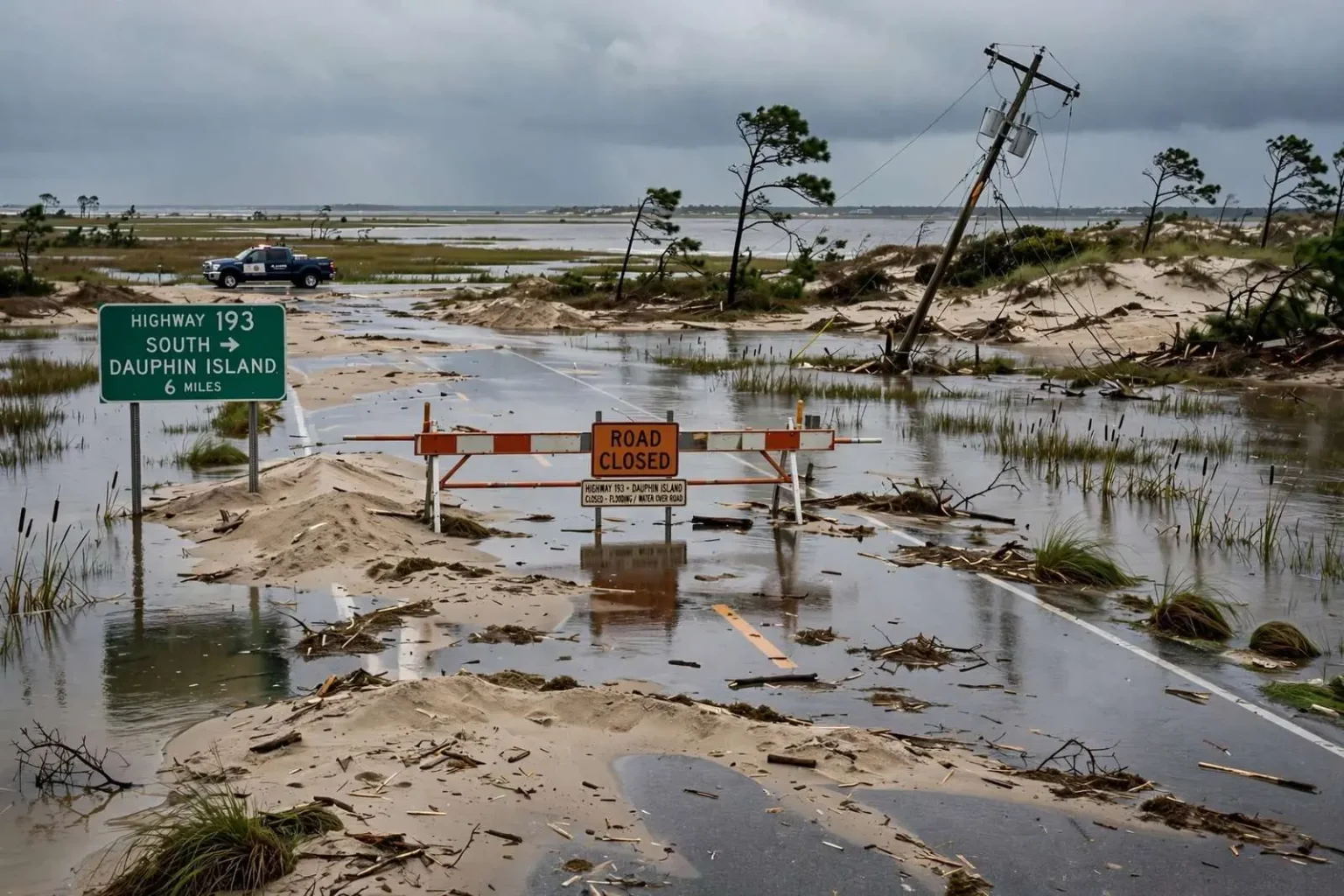
Wind and waves flooded low-lying parts of south Mobile County in September 2008, according to a local news report from the time, as storm surge pushed water into communities along the coast and around Mobile Bay. The event came during one of the most active hurricane seasons on record, and while the worst impacts of that September’s storms stayed far to the west, their reach was wide enough to send Gulf water over roads and into neighborhoods on Alabama’s barrier island and along the bayfront.
The surge effects were felt most acutely at the coast. On the Dauphin Island Parkway corridor and the routes that serve the island, access became a central concern as water covered low stretches of roadway. Highway 193, the primary route connecting mainland Mobile County to Dauphin Island, remained closed to traffic heading to the island, cutting off the usual path for residents, supply runs, and anyone attempting to reach property on the barrier island. Alabama Port residents were allowed through, an exception that recognized the communities on the mainland side of the causeway route while the island itself remained difficult to reach.
On the island, officials reported that the west end of Dauphin Island had received the most damage. That stretch of the island — the narrowest, lowest-lying portion, where homes line Bienville Boulevard facing the Gulf — has historically taken the brunt of surge events, and this storm was no exception. Sand washed across portions of Bienville Boulevard, the island’s main east-west thoroughfare, burying pavement under a layer of Gulf sand that had to be pushed back by heavy equipment before normal travel could resume.
Flooding around the bay and the river communities
The report also described flooding around Fowl River, the community along the tidal river in south Mobile County where waterfront homes and camps line the banks near where the river opens toward Mobile Bay. Surge moving up from the Gulf and bay waters pushed by sustained winds backed into low-lying lots and roads in the area, a familiar pattern for residents of the river communities who have learned to move vehicles and secure property when a storm track points surge toward the bay.
Elsewhere along the eastern shore and the lower bay, the same combination of wind and water produced the routine miseries of a coastal storm: water standing in yards, debris scattered across roads, and docks and boathouses taking the punishment. South Mobile County’s geography leaves it exposed from several directions at once — the Gulf to the south, the bay to the east, and the river systems that drain toward both — so surge events that might be an inconvenience further inland become genuine flooding problems in places like Bayou La Batre, Coden, Mon Louis Island, and the Fowl River area.
Power outages compounded the disruption. The report noted continued power outages on Dauphin Island as the storm’s aftermath stretched on, leaving residents without electricity while crews worked the island’s damaged lines. Barrier island outages are routinely among the last restored after a coastal storm, because crews must first clear roads, work around standing water, and rebuild lines along exposed stretches of shoreline before service can be brought back neighborhood by neighborhood.
Assessing the damage and starting the cleanup
As the water receded, officials prepared to assess damage and begin cleanup across the affected areas. The assessment work that follows a coastal storm is methodical and unglamorous: teams document flooded structures and road damage, public works crews clear sand and debris from the primary routes, and utility crews work the outage list. On Dauphin Island, the sand on Bienville Boulevard was among the most visible cleanup tasks, since the main road had to be passable before residents and inspectors could reach the west end to evaluate property damage.
The closure of Highway 193 during the event illustrated the access dilemma that defines every Dauphin Island storm. The route across the Gilliard Channel bridge is the island’s only road link to the mainland, so closing it protects drivers from water over the roadway but also delays residents trying to reach their property. Officials kept the closure in place for traffic bound for the island while allowing Alabama Port residents through, a balancing act between safety and the practical needs of the communities along the route.
For residents of the island’s west end, the September 2008 event fit a pattern that has repeated across the years. The west end sits at the narrow tail of the island, where storm surge can wash water from the Gulf to the sound side and rearrange sand, roads, and homes in a single event. Each surge brings the same sequence: water over Bienville Boulevard, sand to clear, outages to restore, and an assessment of which structures took damage that cannot be repaired in place.
The September 2008 context on the Gulf Coast
September 2008 was a punishing month for the Gulf Coast even far from landfall. The season produced a series of hurricanes whose winds and surge reached across the entire northern Gulf, and coastal Alabama felt the effects of storms that ultimately came ashore hundreds of miles away. Surge is not strictly a local phenomenon — water pushed by a storm’s wind field piles up along the whole coast and sloshes into bays, sounds, and rivers, sometimes most severely in places well east or west of the point of landfall. That is what south Mobile County experienced: a storm whose center never came near Alabama still pushed enough water into the area to close highways, flood river communities, and knock out power to the island.
The pattern is a lesson local emergency managers repeat every season. Residents of Dauphin Island, Bayou La Batre, Coden, and the Fowl River area do not need a direct landfall to see flooding; a distant hurricane with the right track and a long duration of onshore flow can do the job on its own. The 2008 event, summarized in the local report, is remembered for exactly that reason — damage and disruption in Alabama caused by a storm that was, in the geographic sense, someone else’s hurricane.
What followed the event was the standard recovery rhythm for the Alabama coast. Roads reopened as water drained and sand was cleared. Power crews restored service to the island. Residents repaired what could be repaired, and officials compiled the damage assessments that determine whether the affected communities qualify for state and federal assistance. Life on the coast resumed, with the familiar understanding that the next surge — from a storm named for the Gulf or passing far offshore — is always a matter of when, not whether.
The roads and communities that define south Mobile County
The geography of the affected area explains why a single storm can disrupt so many communities at once. Highway 193 runs south from the Theodore area through the Alabama Port communities toward the Dauphin Island bridge, threading between the bay on one side and the marshes and rivers on the other. Fowl River Road serves the river communities to the east, while the Bayou La Batre and Coden areas sit along the shoreline to the southwest, home to a working waterfront where shrimp boats and seafood houses anchor the local economy. Storm surge moving into the bay and its tributaries touches all of these places in the same event, which is why access closures, flooded roads, and outages tend to arrive together.
Dauphin Island itself occupies a unique place in Alabama’s coastal story. As the state’s only barrier island, it absorbs the first punch of every storm that approaches Mobile Bay, protecting the mainland shoreline and the port infrastructure behind it at the cost of repeated damage to its own beaches, roads, and homes. Bienville Boulevard runs the length of the island’s populated stretches, and sand over that road is the signature image of every significant surge event there — a sign of the island doing exactly what a barrier island does.
What the 2008 event left behind
For the people who lived through the September 2008 flooding, the practical aftermath looked the way it always does on the Alabama coast: water-stained walls, ruined flooring, sand to shovel, docks to rebuild, and days without power followed by the slow return of normal services. The report’s summary of Highway 193’s closure, the west end damage, the Fowl River flooding, and the island’s outages reads as a catalog of the standard coastal storm experience, compressed into a few days of disruption.
Today, more than a decade and a half later, conditions on the coast reflect years of rebuilding, beach renourishment debates, elevated construction on the island’s west end, and continued investment in the roads that serve the area. Current conditions may differ from what the 2008 report described, and the communities of south Mobile County have changed in the years since. But the underlying geography has not moved: the low ground is still low, the island still shields the bay, and the September 2008 event remains a useful reminder that Alabama’s coast takes damage from storms that never come anywhere near a direct hit.