Storm Chances Build Across Mobile and Baldwin Counties This Week as Tropical Storm Bret Forms
Scattered showers and thunderstorms remain in the forecast for Mobile and Baldwin counties this week, while Tropical Storm Bret has formed in the Atlantic and forecasters watch a second wave that could become Tropical Storm Cindy.
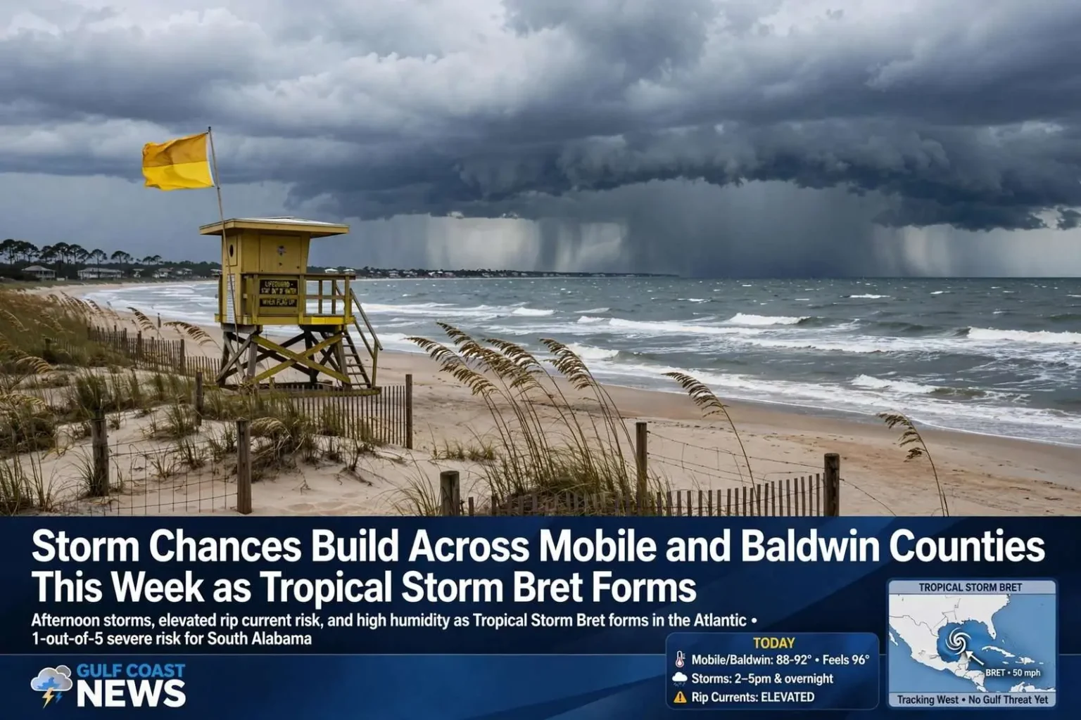
A calm start to the morning across South Alabama gave way to renewed storm chances heading into the afternoon, following a stretch of unsettled weather the day before. Forecasters say the highest probability for showers and thunderstorms will sit over southern Mobile and Baldwin counties in the early afternoon hours, with activity expected to shift toward inland communities later in the evening and overnight.
The Storm Prediction Center has placed the region in a 1-out-of-5 risk category for a few stronger storms, meaning most activity should remain garden-variety but a handful of storms could turn more intense. The lowest rung of the center’s five-point severe weather scale is a familiar placement for Gulf Coast summer days, when heat and humidity build enough to pop scattered storms without organizing them into widespread severe weather.
The primary hazards being watched are gusty winds and heavy, fast-falling rain that can lead to localized flooding on area roadways. Summer storms in the Mobile area can drop intense rain in short periods, and low-lying streets that drain poorly can pond quickly, catching drivers who try to cross standing water. Forecasters and emergency managers repeat the same advice every season: turn around, don’t drown.
Daytime highs are expected to climb into the mid- to upper 80s and lower 90s, but with humidity levels running high, it will feel more like the mid- to upper 90s for anyone spending extended time outdoors. Overnight lows will stay mild and muggy, settling into the 70s, offering little relief for residents without air conditioning and keeping the atmosphere primed for the next day’s storms.
Forecasters urge residents planning outdoor work or recreation to build their schedules around the storm window. Roofers, landscapers, and construction crews across the two counties routinely plan around afternoon downpours this time of year, and youth sports leagues and summer camps keep a close eye on lightning, which is the most dangerous and least predictable hazard in any scattered storm setup. The 30-minute rule — waiting half an hour after the last rumble of thunder before returning outdoors — remains the standard guidance.
Looking ahead to tomorrow, rain chances tick up further, with more scattered showers and thunderstorms expected. Daytime highs will hold steady in the upper 80s to lower 90s. Forecasters say this hot, humid and unsettled weather pattern is likely to persist into the weekend, a typical summer setup for the Gulf Coast, where daily storms are as much a part of the season as the heat itself.
Beach hazards remain elevated
Beachgoers should take note that rip current risks remain elevated along area beaches and are expected to stay that way through the weekend. Rip currents are a leading cause of ocean rescue calls and drownings along the Alabama coast during summer months, and swimmers are urged to check flag conditions and swim near a lifeguard when possible.
The combination of afternoon storms and rough surf is a common midsummer pairing along the Alabama coast, when persistent onshore winds churn up the Gulf even between storm systems. Visitors staying at the beach for the weekend should expect changing conditions from morning to afternoon and plan swimming for the guarded stretches of shoreline.
The flag warning system used at Alabama’s public beaches gives swimmers a daily read on conditions, with green flags signaling low hazard, yellow indicating moderate surf, and red flags marking high hazard. Double red flags close the water entirely. The beaches at Gulf Shores and Orange Beach post flag conditions at public access points, and visitors arriving for a weekend on the water are urged to check the flags before wading in — and to remember that conditions can change with the tide and wind over the course of a day.
Rip currents form when waves and channel shapes funnel water away from shore in narrow, fast-moving streams that can pull even strong swimmers away from the beach. The standard advice remains the same: stay calm, don’t fight the current directly, and swim parallel to shore until free of the pull, then angle back toward the beach. Lifeguards at the Gulf Shores and Orange Beach public beaches perform rescues throughout the summer, and the majority of calls involve swimmers caught in rip currents who were outside guarded areas.
Tropical Storm Bret forms in the Atlantic
In the tropics, Tropical Storm Bret has officially formed in the Atlantic. Forecasters expect the system to remain a tropical storm as it tracks westward, passing just south of the Dominican Republic by this weekend. The system’s westward path is the classic track for storms forming in the deep tropical Atlantic during the heart of hurricane season, and its progress is being watched across the Caribbean.
Meteorologists are also watching a second tropical wave trailing behind Bret that could strengthen into a depression or tropical storm within the next two days — if it does, the next name on the list would be Cindy. Two named systems moving in tandem are common in active stretches of the season, when favorable winds and warm water allow wave after wave to organize.
Local forecasters say they will continue monitoring both systems for any potential impact on the Gulf Coast as the Atlantic hurricane season moves into a more active stretch. For now, neither system poses an immediate threat to Alabama, and the more pressing weather story for the weekend remains the daily round of heat, humidity, and afternoon storms.
Storms that form in the far tropical Atlantic take well over a week to cross the basin, which means systems like Bret are watched for days before any forecast can say whether they threaten land at all. Forecasts this far out carry wide error margins, and the only responsible read at this distance is that the season is active and residents should pay attention as the systems’ paths firm up.
The summer pattern, explained
The daily storm cycle that South Alabama experiences this time of year is driven by the same forces that make the region so green in summer: intense heating, abundant Gulf moisture, and sea breeze boundaries that collide over land each afternoon. Morning sun heats the land faster than the water, air rises over the interior, and the resulting instability builds clouds into thunderstorms by early afternoon. Along the immediate coast, the sea breeze often holds storms inland until late in the day, which is why beach visitors frequently enjoy dry mornings before storms arrive in the afternoon and evening.
That rhythm is why forecasters describe the upcoming pattern as typical rather than unusual. The main variables from day to day are how far west the storms track, how strong the strongest cells become, and whether any of them organize enough to warrant warnings. With the region placed in the lowest severe risk category, forecasters expect most days to pass without significant damage, while cautioning that any single storm can still produce dangerous lightning, gusty winds, and brief downpours.
Time to check hurricane plans
Residents are encouraged to review their hurricane preparedness plans now, well ahead of any storm that might pose a direct threat later in the season. Emergency managers across Mobile and Baldwin counties repeat the same checklist every year: know your evacuation zone if you live near the coast, keep vehicles fueled, maintain a supply of water, medications, and nonperishable food, and have a plan for pets and for family members with medical needs.
The formation of Bret and the wave behind it is a normal part of the season’s rhythm, but it is also the kind of reminder that preparedness officials prefer residents act on early. Supplies are easier to find, and decisions are easier to make, before a storm is aiming at the Gulf — not after.
For Baldwin County’s beach communities, the math of a hurricane season is always close to home. The same beaches that draw summer crowds sit at sea level, and evacuation decisions there run on tighter timelines than almost anywhere else on the Gulf Coast. Emergency managers in Gulf Shores and Orange Beach coordinate with the county each season on re-entry plans and visitor notifications, knowing that a summer weekend can place tens of thousands of out-of-town guests on the island roads with little knowledge of local evacuation routes.
For now, the forecast for South Alabama is a familiar one: hot afternoons, scattered storms, elevated rip current risk at the beaches, and forecasters watching the Atlantic. Residents heading to the Gulf Shores and Orange Beach beaches this weekend should keep an eye on the flags, drink plenty of water, and plan outdoor activities around the afternoon storm window.
The next few days bring no changes to that picture, and the weekend forecast holds steady — upper 80s to lower 90s, scattered showers and storms, and a tropics worth watching but not worrying about yet.