Summer Heat Tightens Its Grip Along the Gulf Coast as Rain Chances Fade
South Alabama is turning hotter and drier this week, with heat index values near 100 degrees, moderate rip currents at the beaches and a quiet tropics.
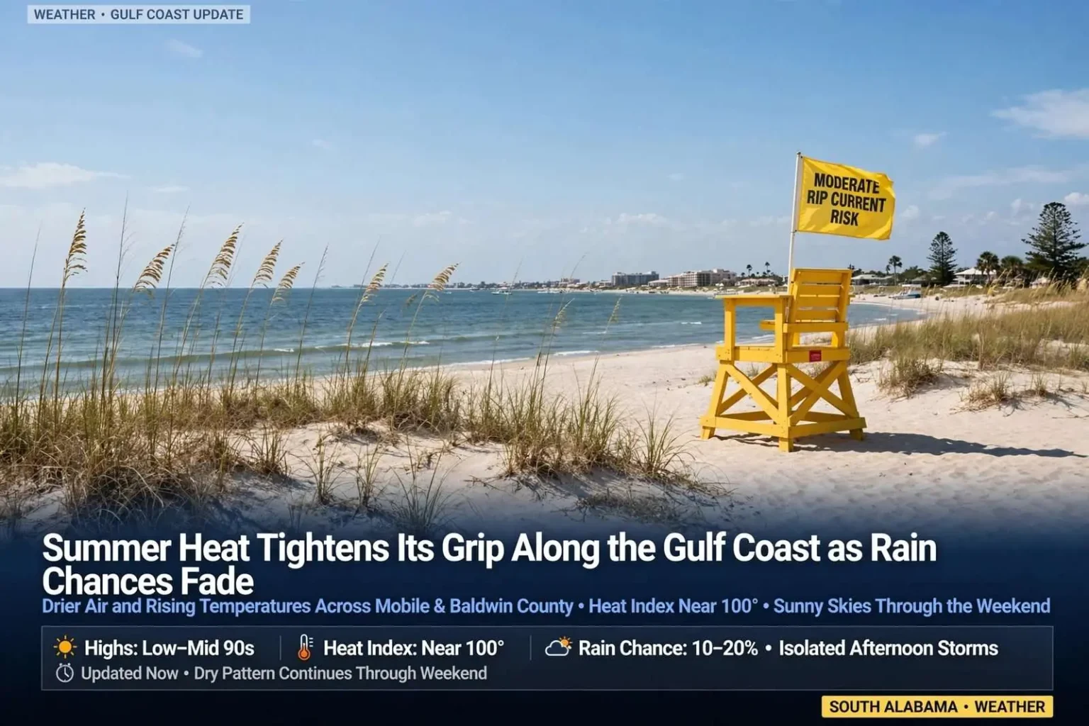
South Alabama is sliding back into a classic summertime pattern this week, with drier air moving in and afternoon temperatures climbing right along with it. Forecasters say most communities across the Mobile and Baldwin County area should expect fewer pop-up storms over the next several days, even as the heat index pushes back into triple digits during peak afternoon hours. After a stretch of wetter weather, the shift means outdoor plans are less likely to get rained out this week — but residents will need to trade one set of precautions for another as the mercury rises.
The transition is the kind Gulf Coast residents know by heart. A few days of cloudy, storm-heavy weather gives way to sinking air and sunshine, and the same afternoons that used to deliver a cooling downpour now deliver heat that builds steadily from late morning until early evening. For anyone with work, practice or plans outdoors, the forecast becomes less about dodging rain and more about managing the heat itself.
The drier air behind the change is as important as the sunshine it brings. Humid air holds heat into the evening, keeping overnight lows uncomfortable, while drier air lets temperatures fall after sunset and gives houses a chance to cool. Residents who notice the evening feels different this week are not imagining it — the same shift that trims rain chances is trimming that heavy, lingering warmth after dark.
Sunnier Skies, Rising Heat to Start the Week
Midweek conditions are expected to bring a mix of sun and clouds with only a slim chance of an isolated shower. Most neighborhoods across the region should stay dry, and any storms that do fire up are expected to be brief, driven mainly by daytime heating rather than any larger weather system moving through. Without a front or a tropical feature to organize the atmosphere, storm coverage shrinks to the hit-or-miss variety that forms over inland areas during the hottest part of the day and drifts with the sea breeze.
High temperatures are forecast to reach the low 90s in the afternoon, with heat index values climbing close to the 100-degree mark. The heat index — what the air actually feels like once humidity is factored in — is the number that matters for the body, because humid air slows the evaporation of sweat that keeps core temperature in check. A low-90s afternoon with Gulf moisture in place can feel far more punishing than the thermometer alone suggests.
Health officials and forecasters routinely caution that this kind of heat can be dangerous for anyone spending extended time outside. Taking frequent breaks in the shade, drinking water regularly and avoiding strenuous outdoor activity during the hottest stretch of the afternoon are the standard recommendations during a stretch like this. The guidance matters most for outdoor workers, athletes in preseason conditioning, older residents and anyone whose job keeps them on asphalt or rooftops, where surface temperatures run well above the air temperature.
Residents should also remember that heat builds indoors in places people forget — parked cars, screened porches, unconditioned garages and sheds. Pets left outside need shade and fresh water throughout the day, and the first weeks of a football season in south Alabama have long been among the most demanding stretches of the year for players and band members alike. Anyone supervising outdoor youth activities this week will want water breaks built into the schedule rather than left to chance.
High pressure is the quiet workhorse behind forecasts like this one. As air sinks through the atmosphere under the high, it warms and dries, and it presses down on the smaller clouds that would otherwise grow into showers. That is why the same high that promises a weekend of clear pool weather is also the reason the thermometer keeps climbing — the atmosphere trades rain for heat, and the trade sticks around until the high weakens or moves.
Building Heat Through the Weekend
The hot, mostly dry pattern is expected to continue into the weekend as a strengthening area of high pressure settles over the region. Inland communities could see afternoon highs climb into the middle 90s, while temperatures closer to the beaches are expected to run slightly cooler, in the upper 80s to low 90s, thanks to the moderating effect of Gulf waters. The split is a familiar geography lesson: water warms and cools more slowly than land, so the sea breeze keeps beachfront communities a few degrees more comfortable even on days when inland towns bake.
Rain chances will stay relatively low through the period, with only isolated to scattered afternoon thunderstorms expected on any given day. Many spots may not see rain at all. For lawns, gardens and farmers’ fields, the dry stretch cuts both ways — fewer washed-out weekends, but also less of the nearly daily rainfall that has kept everything green through the summer.
Forecasters note that any storm that does develop, even a brief one, can still produce frequent lightning, heavy rainfall for a short period and gusty winds before dissipating. A storm that lives for twenty minutes can still drop an inch of rain on a single subdivision, flood a low stretch of road and knock power out for a few hours. The safest approach is to treat every afternoon storm as serious regardless of how small it looks on radar.
The Mobile area’s summer storms behave differently depending on where they form. Storms that develop over the inland counties in the afternoon often drift toward the coast as the sea breeze pushes inland, while storms that start over the Gulf can slide ashore in the evening with little notice. Either way, the rain they deliver tends to be intense but brief, and most neighborhoods dry out within the hour.
Lifeguards along the Alabama coast perform rescues on moderate risk days every season, and the majority involve swimmers who never noticed they had drifted. The currents pull swimmers away from shore through narrow channels, often exactly where the water looks calmest between breaking waves. Families visiting from inland areas should take a moment to point out the flags to everyone in the group, including teenagers who consider themselves strong swimmers.
Beach and Boating Conditions
Beachgoers along the Alabama Gulf Coast should continue to watch for a Moderate Rip Current Risk, which remains in place at area beaches even as the rain chances drop. The connection surprises some visitors: clear skies and calm-looking water do not mean safe water, because rip currents are driven by wave patterns and underwater topography rather than the weather overhead. Swimmers are urged to check the posted beach warning flags before entering the water and to stay near a lifeguard whenever possible.
A moderate risk means rip currents are possible and can become dangerous for weaker swimmers, particularly near jetties, piers and sandbars where currents concentrate. Anyone caught in one should stay calm, swim parallel to shore until free of the current and then angle back to the beach — fighting it directly is the mistake that turns a manageable situation into a rescue. Lifeguards at Gulf State Park beaches and the municipal beaches along the coast fly the flag system daily, and checking it takes only a minute before a swim.
For those heading out on the water, boating conditions are expected to be generally favorable outside of any isolated afternoon storms. Boaters are advised to keep an eye on the sky throughout the day, since a fast-developing storm can bring dangerous lightning, sudden wind gusts, rough seas and even an isolated waterspout with little warning. The classic summer rhythm applies: mornings are typically the calmest window, and the open water gets riskier from mid-afternoon onward as the heat fuels storm development over the bay and Sound.
Waterspouts deserve particular respect from small-craft operators. They can form quickly beneath the same towering clouds that produce the afternoon storms, and while most are short-lived, they can generate hazards out of proportion to their size. Boaters who see a dark, rotating cloud base or a funnel forming have every reason to change course early rather than wait to see how it develops.
Boaters launching from the area’s public ramps should also plan fuel and supplies around the early-start strategy. A morning departure offers not just calmer water but cooler temperatures on deck, a fuller day of fishing or cruising before the storm window opens and an easy margin if the afternoon forecast turns. The boaters who get caught in trouble most often are the ones who left at noon and met the weather halfway back.
Tropics Remain Quiet
Despite the region being deeper into hurricane season, there is no tropical development expected across the Atlantic Basin over the next seven days. Forecasters say there are currently no areas of concern to track, giving South Alabama a quiet stretch on the tropical weather front even as the heat builds at home. A quiet basin in the heart of the season is a welcome breather, and it gives households a low-pressure window to review supplies and plans without a named system forcing the issue.
The calm should not invite complacency. Hurricane season runs through the end of November, and the Gulf’s most dangerous stretches have historically arrived with little notice in late summer. The standard advice holds in quiet weeks and busy ones alike: keep basic supplies current, know whether your home is in an evacuation zone and keep a way to receive warnings when the pattern changes.
Residents are encouraged to stay tuned to local forecasts for updates as the pattern evolves through the week. For now, the forecast is simple by south Alabama standards — hot, mostly dry and quiet in the tropics — with the main hazards being the heat itself, the afternoon storm that pops up out of nowhere and the rip currents that never take a day off, whatever the sky looks like.