Third earthquake in less than a week shakes the Gulf Coast near Flomaton
A magnitude 2.3 earthquake struck just north of Flomaton on Tuesday, the third tremor in less than a week to hit the Gulf Coast region.
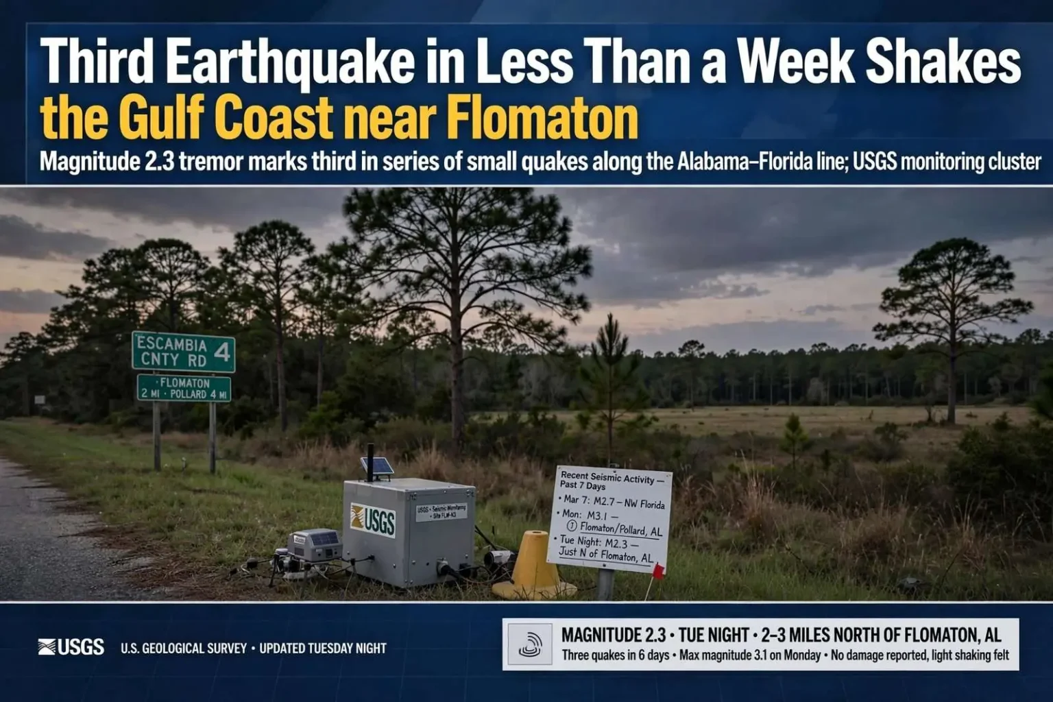
For the third time in less than a week, an earthquake has struck the Gulf Coast. The latest, a magnitude 2.3 tremor, occurred Tuesday night just north of Flomaton, according to the U.S. Geological Survey. On March 7, a magnitude 2.7 earthquake struck northwest Florida. And on Monday, a 3.1 magnitude quake hit near Flomaton and Pollard — a rapid series of small earthquakes that put residents of the Alabama-Florida state line region on notice that the ground beneath them has been restless.
The Tuesday night tremor was the weakest of the three, but its location — just north of Flomaton in Escambia County — placed it close enough to the earlier Monday quake that seismologists track such clusters with interest. While magnitude 2.3 earthquakes are rarely felt by anyone not sitting perfectly still near the epicenter, residents in the area reported the recent quakes in sufficient numbers that the U.S. Geological Survey’s felt-report maps lit up for the region.
The sequence began in earnest on Monday, when a magnitude 3.1 earthquake struck near Flomaton and Pollard, two communities that sit side by side in Alabama’s Escambia County just below the Florida line. Magnitude 3.1 is still a small earthquake by global standards, but it is large enough to be felt indoors — a quick shudder, a rattling window, a picture frame shifting on the wall. Then came the March 7 magnitude 2.7 event across the line in northwest Florida, and finally Tuesday night’s magnitude 2.3 north of Flomaton.
The Flomaton Seismic Zone
Residents of south Alabama are often surprised to learn that their region has a seismic history at all, but the area around Flomaton and Pollard sits within one of the more active pockets of seismicity in the southeastern United States. The zone, sometimes associated with the ancient geologic structures buried deep beneath the Gulf Coastal Plain, has produced small earthquakes on a recurring basis for decades. Most are magnitude 2 or 3, felt by few or none, but the cluster near Flomaton has drawn attention from scientists and residents alike over the years.
The U.S. Geological Survey maintains a nationwide network of seismic monitors that records these events automatically, pinpointing their locations and magnitudes within minutes. For a small quake in south Alabama, the data gathering is routine — but a rapid series of three events in a week is enough to make seismologists and emergency managers take note, even when the individual tremors pose no meaningful threat.
Earthquakes of this size do not damage buildings or injure people. The scale is exponential: each whole-number step up in magnitude represents roughly thirty-two times more energy released. A magnitude 3.1 quake releases only a tiny fraction of the energy of the destructive quakes that strike California or Japan. What makes the recent series notable is not its power but its clustering — three events in quick succession in a region where months can pass without any felt seismicity.
What Residents Felt
In Flomaton, Pollard, and the surrounding communities, the earthquakes announced themselves differently depending on where people were and what they were doing. Some residents reported a low rumble or a sharp jolt; others felt nothing at all and learned of the quakes only when the USGS reports appeared online and local news coverage followed. The Monday magnitude 3.1 event drew the most reports, with the Tuesday night magnitude 2.3 tremor felt by fewer people as it was smaller.
The USGS encourages residents who feel an earthquake to submit reports through its online “Did You Feel It?” system, and the responses from Escambia County helped scientists map the extent of each tremor’s reach. Those reports are more than curiosities — they help researchers understand how seismic waves travel through the Gulf Coast’s thick sediments, information that matters for estimating how a larger quake, should one ever occur, would affect the region.
For longtime residents of the state line communities, small earthquakes are an oddity they have learned to live with. Some locals recall previous swarms over the years, and the stories get retold each time the ground moves: the washing machine that walked across a porch, the dishes that rattled, the first instinct that a passing truck had hit a bump. Tuesday night’s tremor added a new entry to the collection.
Could Bigger Quakes Follow?
The question that naturally follows any swarm is whether larger earthquakes are possible, and the honest answer from seismology is that small earthquakes do not reliably predict large ones. Most swarms simply fade away. The eastern United States does have a history of damaging earthquakes — the famous New Madrid events of 1811-1812 far to the north being the most cited — and building codes in much of the Southeast account for at least some seismic risk.
In south Alabama, the practical risk from a magnitude 3-class quake is negligible. Structures are not designed for the kind of shaking those quakes produce, and no damage was reported in connection with the three recent events. Emergency management agencies in Escambia and neighboring counties monitor the situation through the USGS feeds but treat the tremors as a scientific curiosity more than a public safety issue.
Still, the sequence — a magnitude 3.1 near Flomaton and Pollard on Monday, a magnitude 2.7 in northwest Florida on March 7, and a magnitude 2.3 just north of Flomaton on Tuesday night — gave the Gulf Coast an unusual week of seismic news. For the residents along the Alabama-Florida line, it was a reminder that even in a region known for hurricanes rather than earthquakes, the earth occasionally writes its own headlines.
Why the Gulf Coast Shakes
The geology beneath south Alabama explains the region’s occasional tremors. The Gulf Coastal Plain is built on layers of sediment deposited over millions of years, but far below those sediments lie ancient faults — remnants of tectonic history stretching back hundreds of millions of years to when the land that is now Alabama sat in vastly different configurations. Those deep structures are generally quiet, but stresses in the earth’s crust occasionally cause them to slip, producing the small earthquakes that rattle the state line communities from time to time.
Scientists studying eastern North American seismicity note that these intraplate earthquakes — quakes occurring far from the boundaries where tectonic plates collide — remain imperfectly understood. The faults that produce them are old, poorly mapped, and buried under thousands of feet of sediment, which makes prediction impossible and even attribution difficult. What is known is that the southeastern United States experiences small earthquakes regularly, and that certain zones, including the one near Flomaton, produce them more often than their surroundings.
The sediment blanket of the coastal plain actually affects how quakes feel. Soft sediments can amplify shaking at the surface, meaning a modest quake can be felt over a wider area than the same event in harder rock. That is one reason residents across a several-county area can report feeling a magnitude 3 earthquake, while similarly sized quakes elsewhere go unnoticed.
The USGS at Work
The U.S. Geological Survey’s rapid earthquake reporting is a modern marvel that residents of Flomaton and Pollard benefit from every time the ground moves. Seismic stations scattered across the country detect the waves from an event within seconds, and automated systems calculate a preliminary location and magnitude, posting the results online within minutes. Residents can then add their observations, turning a scientific detection into a community record.
For the recent three-quake sequence, the USGS entries documented the progression precisely: the magnitude 3.1 near Flomaton and Pollard on Monday, the magnitude 2.7 in northwest Florida on March 7, and the magnitude 2.3 north of Flomaton on Tuesday night. Seismologists reviewing the data would look at the depths, locations, and timing to assess whether the events were related — a common question with earthquake swarms, where stress redistributes through a small fault system and sets off a series of adjustments.
Each felt report submitted by residents improves the scientific record. The intensity maps built from those reports show how shaking faded with distance from the epicenter, data that feeds into the national hazard models used by engineers, insurers, and emergency planners. Even in a region where hurricanes dominate emergency planning, that quiet background work matters.
Life Along the State Line
Flomaton and Pollard sit in the southern reaches of Escambia County, Alabama, twin small communities whose histories are tied to the railroads and timber that built the region. Just across the line, the Florida towns of the western panhandle share the same pine forests, the same churches, and the same weather — and, as the past week demonstrated, the same occasional earthquakes. The March 7 event in northwest Florida was close enough that residents on both sides of the line felt the week’s shaking.
The communities are better known for preparing for tropical weather than seismic events. Hurricane season is the calendar’s dominant fact of life here, with evacuation routes, storm shutters, and generator checklists part of the annual rhythm. Earthquake preparedness, by contrast, barely registers — and reasonably so, given that the region’s recorded quakes have never approached damaging levels.
Still, the three tremors in less than a week gave the region’s news outlets something unusual to cover, and gave residents a new conversation topic at church and at the store. Whether the swarm has ended or more small quakes will follow, the ground beneath the Alabama-Florida line has reminded everyone that the Gulf Coast’s natural history includes more than storms. For now, the U.S. Geological Survey’s monitors keep watch, the residents of Flomaton and Pollard keep their eyes on any rattling windows, and south Alabama adds another chapter to its quiet seismic story.