Three Small Earthquakes Rattle the Flomaton Area in One Day
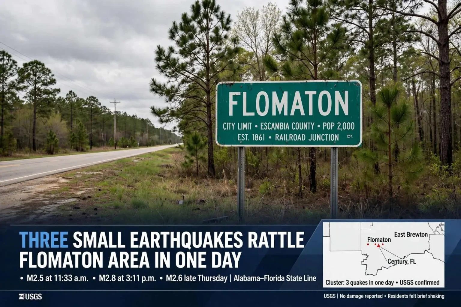
The USGS recorded three small earthquakes near Flomaton in one day, magnitudes 2.5, 2.8 and 2.6, following five quakes in the region a month earlier.
Three earthquakes were recorded near Flomaton on Thursday, adding to a string of small seismic events along the Alabama-Florida line this spring. The USGS network picked up all three within a span of hours, capping a month that has made this quiet corner of south Alabama one of the more seismically active spots in the eastern Gulf Coast region. Residents who felt the tremors reported the familiar experience of a sudden shake with no obvious explanation — and Thursday gave them three chances to feel it.
The first quake, a magnitude 2.5, was recorded around 11:33 a.m. The midday timing meant many people in the Flomaton area were awake and active when it hit, and the light shaking was likely felt indoors by anyone paying close attention, though events of this size often go unnoticed by people who are moving around or driving. Seismographs, which detect ground motion far more sensitively than human perception, logged the event precisely even where residents felt little or nothing.
A second and slightly stronger event, magnitude 2.8, followed at about 3:11 p.m. The gap of a few hours between the first two events is typical of earthquake sequences in intraplate regions, where stress releases in scattered pockets rather than along a single defined rupture. A magnitude 2.8 remains well below the damage threshold, but it is squarely in the range that people near the epicenter can feel — a brief jolt or a low rumble, sometimes accompanied by the rattling of windows and dishes.
The U.S. Geological Survey later reported a third quake in the same area, measured at magnitude 2.6, late Thursday. Three felt-capable events in a single day will draw attention in a region unaccustomed to earthquakes, and the pattern confirmed that the source zone beneath the Alabama-Florida line was producing repeated, small ruptures rather than a single isolated event. USGS instruments placed across the country recorded each event within moments of its occurrence.
Part of a Longer Pattern
The activity follows five quakes recorded in the region the previous month, two near Flomaton, two near East Brewton and one across the state line at Century, Florida. The cluster spanning the three communities suggests a source zone beneath the state line area, where Escambia County, Alabama meets the western Florida Panhandle. East Brewton sits a short distance north of Flomaton along the corridor, and Century lies just across the line in Florida, putting the recent epicenters within a compact triangle of small towns.
Quakes in this magnitude range are generally felt as a brief jolt or rumble by people close to the epicenter and rarely cause damage. Structural damage from earthquakes generally begins at magnitudes in the mid-4s and higher, leaving everything in the recent sequence far below the level that threatens buildings or infrastructure. The practical effect for residents is nuisance and unease rather than danger — a picture frame knocked askew, a startled pet, a moment of confusion about what just moved.
East Brewton’s own role in the cluster underscores how compact the affected area is. The town anchors the northern end of the recent epicenters, while Century defines the southern edge across the state line, and Flomaton sits between them along the transportation corridor that ties the three communities together. Residents across that triangle have shared their experiences of the same sequence of tremors, comparing notes on what time the shaking came and how strongly it registered.
No injuries or damage were reported in connection with Thursday’s events. The absence of harm was expected given the magnitudes involved, but local officials still take reports of felt shaking seriously, since public reports help seismologists map where shaking was strongest and refine the location of the epicenters. USGS “Did You Feel It?” reporting systems collect exactly that kind of resident feedback after each event.
Flomaton sits in Escambia County, Alabama, along the state line at the junction of U.S. 29 and the railroad lines that have shaped the town since its founding as a railroad junction in the late 19th century. The town of roughly 2,000 residents sits at the gateway between south Alabama’s pine belt and the Florida Panhandle, with Interstate 65 passing just to the east. East Brewton and Brewton lie to the north along the Conecuh River, and the broader area remains one of rural timber country.
Why It Happens Here
Northern Escambia County and the adjoining corner of the Florida Panhandle sit far from any major plate boundary, so earthquakes there are small and infrequent by national standards. Earthquakes in the eastern United States are overwhelmingly concentrated along the Atlantic seaboard, the New Madrid zone of the central Mississippi Valley, and the Eastern Tennessee seismic zone — none of which extend to the Alabama-Florida line. What the Gulf Coast experiences instead are scattered releases of stress within the North American plate itself.
Geologists attribute earthquakes in this part of the Gulf Coastal Plain to ancient, deeply buried faults in the earth’s crust — structures left over from the formation and breakup of ancient landmasses hundreds of millions of years ago. Those faults lie hidden beneath layers of sediment accumulated over eons, and regional tectonic stresses occasionally cause small segments to slip. Because the faults are buried and the stress is low, the resulting earthquakes are almost always minor — but they can repeat in the same source zone as stress redistributes.
Clusters of low-magnitude tremors like these are still tracked closely by the USGS because they help refine understanding of the region’s minor fault activity. Each recorded event adds data points that sharpen the picture of where the buried faults lie and how the stress field across the region is oriented. Sequences like the one along the Alabama-Florida line are scientifically valuable precisely because they are rare enough to be notable but frequent enough to reveal patterns.
What Residents Should Know
For people living in the Flomaton, East Brewton and Century area, the recent sequence does not signal that a large earthquake is coming, according to what is generally understood about swarms of this kind. Earthquake sequences in stable continental regions cannot be predicted with precision, but the overwhelming majority of small events are followed only by more small events or by quiet. Building codes in Alabama and Florida do not treat the Gulf Coast as a high-seismic-risk zone, and no special precautions are recommended for earthquakes of this size.
That said, residents who feel shaking are encouraged to report it. Felt reports help the USGS distinguish between events that were genuinely perceptible and those that passed unnoticed, and the aggregated data feeds the agency’s shaking intensity maps. In a region where earthquakes are uncommon, those reports also give neighbors a way to confirm that what they felt was real — a reassurance that matters when the ground moves without warning.
The timing of the sequence through the spring has given the area’s emergency management agencies a low-stakes exercise in earthquake awareness. Escambia County’s emergency management office monitors USGS alerts alongside its usual work on hurricanes, tornadoes and flooding — the hazards that actually dominate the Gulf Coast risk landscape. Thursday’s quakes prompted no emergency response beyond the routine monitoring that follows any felt event in the region.
How Earthquakes Are Measured
The magnitudes reported for Thursday’s quakes come from the standardized scales seismologists use to describe the energy released by an earthquake. Each whole-number step represents roughly a tenfold increase in the amplitude of ground motion, which is why a magnitude 2.8 feels noticeably different from a magnitude 2.5 even though both are small. Modern detection depends on dense networks of seismometers that record ground movement and transmit the data to processing centers that locate and size each event within minutes.
The USGS National Earthquake Information Center in Golden, Colorado, serves as the clearinghouse for earthquake reports nationwide, reviewing automated detections and publishing official locations and magnitudes. Events as small as Thursday’s are routinely detected in the eastern United States thanks to network coverage that has expanded considerably over the past two decades, meaning small quakes that once went unrecorded now become part of the documented record.
Whether the sequence near Flomaton continues, intensifies or fades will become clear in the weeks ahead. Seismic swarms in stable regions typically diminish over time, though some continue episodically for months. Residents can follow the USGS earthquake catalog online for updates, and any future felt events will be recorded with the same precision that documented Thursday’s three quakes.
For now, the three tremors of Thursday — magnitude 2.5 at midday, 2.8 in the afternoon and 2.6 late in the evening — take their place in the growing record of small earthquakes along the Alabama-Florida line, a reminder that even the quietest corners of the Gulf Coast sit on a crust that is never entirely still.