Tropical Storm Cristobal Floods Downtown Mobile Streets, Stranding Drivers
Streets off Water Street in downtown Mobile flooded during Tropical Storm Cristobal, leaving one car stranded and drivers cautious.
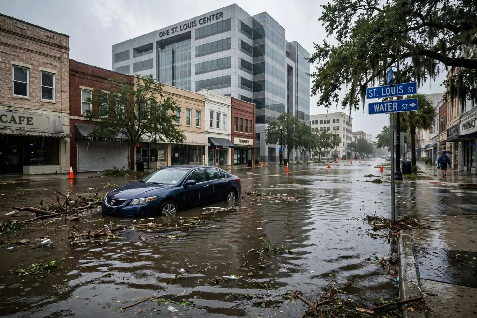
Streets in downtown Mobile took on water Monday as the remnants of Tropical Storm Cristobal moved through the Gulf Coast, leaving at least one driver’s car stranded and others wary of venturing through flooded roadways. The worst of the ponding was concentrated on streets leading off Water Street, including St. Louis and St. Anthony, where standing water covered stretches of pavement through much of the day.
The flooding was a familiar sight for downtown Mobile, where the low-lying blocks near the riverfront have long been the first to pond when heavy rain falls on the city. Drivers who work in and commute through downtown know the pattern, but even experienced motorists found some of Monday’s water deeper than it looked — with one driver paying for the misjudgment with a tow bill.
Cristobal, which made landfall in Louisiana before its remnants pushed inland, spread bands of heavy rain across the central Gulf Coast through the day. Downtown Mobile’s storm drains, working against sustained rain and high moisture already in the ground, struggled to keep pace on the streets closest to the water.
Driver Learns a Costly Lesson
One woman had to have her car towed from St. Louis Street after attempting to drive through what turned out to be deeper water than it appeared. “It was very deep. I don’t know, it just happened. It did not look like it was that deep, and it mostly doesn’t,” she said.
Her experience is a textbook illustration of the deceptive look of flooded streets. Water that covers pavement in a thin-looking sheet can hide dips in the roadway that turn inches of visible ponding into feet of actual depth. By the time a driver feels the water pulling at the wheels, it is often too late to back out safely.
Tow operators around downtown spent portions of Monday pulling vehicles from the flooded stretches, a routine consequence of any significant rain event on the city’s low blocks. The cost of a tow is the smallest of the potential consequences; stalled engines, water-damaged electrical systems and totaled vehicles are the typical outcomes when cars push through water deeper than their owners realized.
Others downtown said they simply avoided the flooded blocks altogether. One woman described the unsettling experience of navigating around the water: “It is crazy right now. I thought I was going to float down this road — so it was definitely scary.”
The decision to turn around rather than push through is exactly what safety officials recommend, and on Monday it was the difference between a soggy commute and a stranded vehicle. Motorists who know the downtown grid — and which streets pond first — generally build alternate routes into their storm-day routines.
Where the Water Pooled
Water Street runs along the western edge of Mobile’s riverfront, and the streets that branch off it toward the interior — including St. Louis and St. Anthony — sit at elevations where rainwater collects before it can drain. When Gulf systems dump sustained rain on the city, those blocks are typically the first to show standing water and the last to clear.
The geography is a legacy of the city’s riverfront origins. Downtown Mobile was built on ground that slopes gently toward Mobile Bay and the Mobile River, and generations of development have not changed the fundamental reality: water that falls on the low blocks has a long way to travel before it reaches the drainage system that carries it away. Heavy rain simply outruns the pipes.
Ponding on St. Louis and St. Anthony is so routine in major rain events that many downtown workers treat it as a seasonal marker — the sign that a Gulf system is making itself felt on the city. Monday’s flooding fit the established pattern, arriving with the day’s heaviest rain bands and lingering through the hours when the rain fell hardest.
Water Receding as Rain Eases
Conditions improved as the day wore on. Photos sent in by an employee at One St. Louis Center earlier Monday showed floodwater that had visibly decreased by later in the day as the rain subsided. The photographs captured the usual rhythm of a Mobile flood event: streets that look impassable at midday are merely damp by the evening commute.
One St. Louis Center, the office tower that anchors the block, sits directly in the zone where ponding collects, and views from its upper floors offer a clear picture of how the water rises and falls across a rainy day. Employees there watched the water creep across the surrounding streets through the morning, then retreat as the storm’s rain bands moved on.
The photographs shared from the building documented the timeline in a way that words rarely capture: water lapping across the intersections near the tower in the morning, standing in sheets across the parking areas by midday, and visibly gone from most of the pavement by late afternoon. For downtown workers, the images served as a practical guide — proof that patience, not a flooded roadway gamble, was the right call.
The recovery once rain eases is usually quick on downtown’s paved grid. Storm drains clear the standing water within hours, leaving behind the debris line of leaves and grit that marks how high the water reached. The danger, though, persists for as long as any standing water remains on the pavement.
The Standing Warning: Turn Around, Don’t Drown
Safety officials routinely warn drivers never to drive through flooded roads, since water depth is difficult to judge and just a foot of moving water can sweep away a vehicle. Taking an alternate route remains the safest choice when streets are under water.
The warning matters as much for what the water hides as for its depth. Flooded streets in downtown Mobile can conceal everything from shifted pavement to debris washed out of yards and lots upstream of the ponding. A driver who cannot see the road surface cannot know whether the route is intact beneath the water, and the few seconds saved by pressing through are never worth the risk.
The warning is repeated every hurricane season because the risk is consistently underestimated. A car can begin to float in as little as a foot of standing water, and two feet of moving water can carry away most vehicles, including SUVs and pickups. Water also conceals roadway damage — a washed-out shoulder or a missing manhole cover can be invisible beneath even a shallow-looking sheet of water.
Federal and state emergency agencies have spent years promoting the “Turn Around, Don’t Drown” message for exactly the scenario that played out on St. Louis Street. The vast majority of flood-related vehicle losses, and a significant share of flood fatalities, involve drivers who attempted to cross water-covered roads rather than find another way around.
Cristobal’s Path Across the Gulf
Tropical Storm Cristobal followed an unusual path to the Gulf Coast, forming in the Bay of Campeche from the remnants of Eastern Pacific Storm Amanda before turning north toward Louisiana. Its landfall made it an early-season storm — a reminder that the Atlantic hurricane season, which begins June 1, does not wait for the traditional August peak to bring tropical weather to the northern Gulf Coast. Coastal residents from Louisiana to the Florida panhandle spent the weekend ahead of the storm watching forecasts that shifted with each advisory.
For Mobile and the rest of the central Gulf Coast, the remnants of a landfalling Gulf storm typically mean bands of heavy rain, gusty winds and the tidal surge that pushes water up into Mobile Bay. Flooding on downtown’s low streets is among the first and most visible effects, arriving hours before any serious wind damage would.
What Residents Can Expect Going Forward
Downtown’s flooding pattern is well documented and predictable, which gives residents and workers practical tools. Commuters who work in the blocks around Water Street can plan routes that stay on higher ground, avoid the streets that pond first, and never gamble on a stretch of water-covered pavement.
The city’s drainage improvements have reduced the worst extremes over the years, but no storm-sewer system can absorb the rain totals that a slow-moving tropical system can deliver. Monday’s ponding on St. Louis and St. Anthony was, by the standards of Gulf Coast storms, a minor event — inconvenient, costly for a few drivers, and gone by evening.
As the hurricane season continues, the same streets will flood again. The lesson of Monday, taught once more at the expense of a towed car, is the one officials keep repeating: the water is always deeper than it looks, and the safest move is always the turn around.
Drivers who need to cross downtown during heavy rain can check conditions before setting out, watch for street-closure barriers that police and public works crews place at the worst ponding points, and remember that the depth of water on any given block can change within minutes as rain bands move through. On days like Monday, the trip that arrives a few minutes late is the one that ends without a tow truck.