Westbound I-10 Bridge Crash Blocked the Shoulder and Slowed Traffic Into Downtown Mobile
A crash on the westbound I-10 bridge in Mobile blocked the right shoulder and slowed traffic heading into downtown.
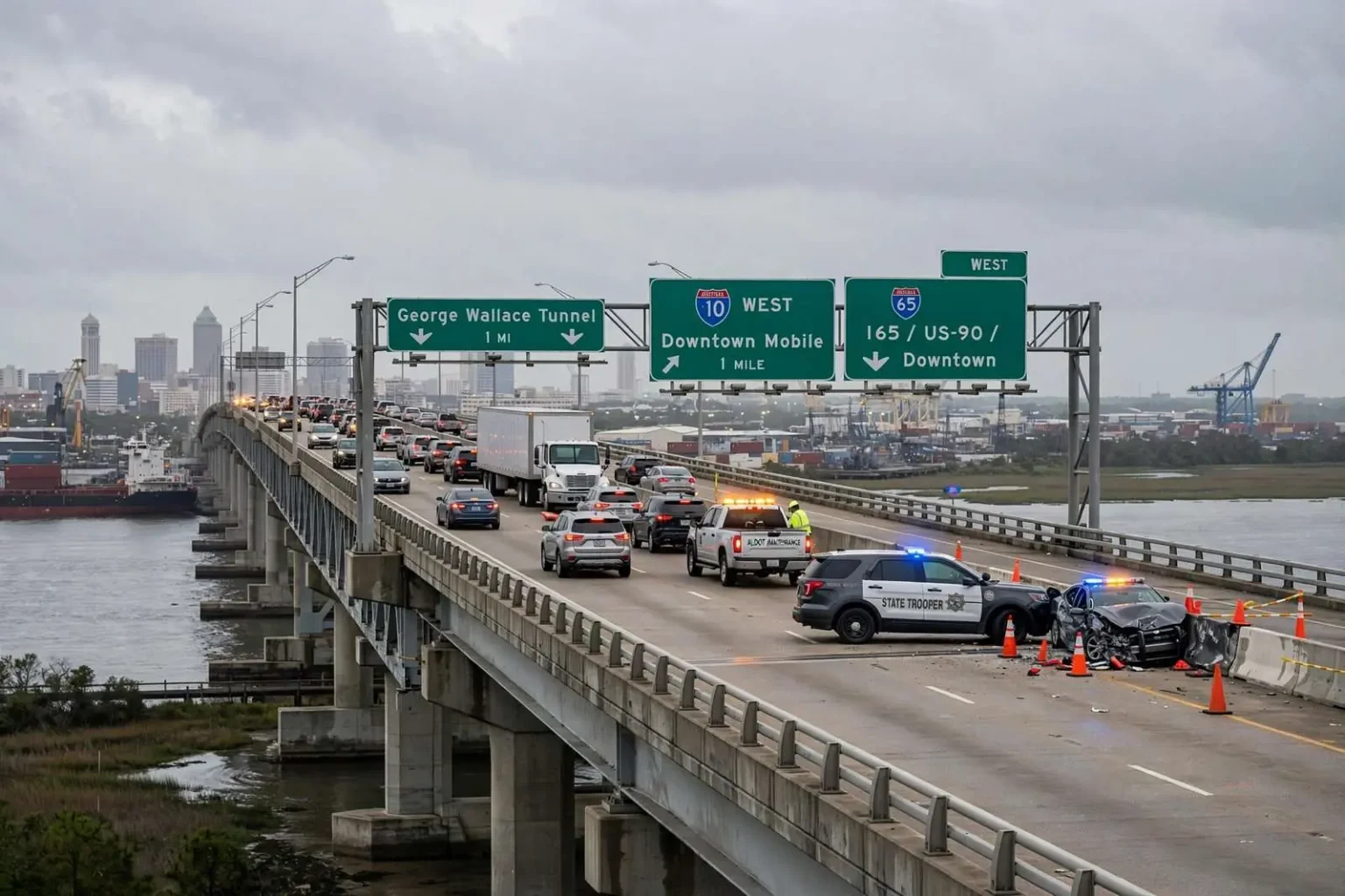
A crash on the westbound Interstate 10 bridge in Mobile blocked the right shoulder and slowed traffic for drivers heading into downtown, according to traffic reports. The wreck occurred on the elevated bridge span that carries I-10 across the Mobile River, a stretch where any incident quickly backs up vehicles coming from the George Wallace Tunnel toward the interchange with I-65 and U.S. 90.
Traffic returned to normal once crews cleared the scene. No details were immediately available about injuries or how many vehicles were involved.
A choke point for the region
The westbound crossing is one of the most congested corridors in South Alabama, funneling Baldwin County commuters through the tunnel system and into downtown Mobile. Even a shoulder-blocking crash there trims the roadway’s capacity at peak hours, producing slowdowns that ripple back toward the Eastern Shore. The geometry explains why: I-10 is the only interstate crossing of Mobile Bay and the Mobile River, which means every vehicle moving between Baldwin County and the Mobile side of the bay — commuters, freight trucks, beach traffic — must pass through the same narrow channel of roadway.
Westbound drivers coming off the Eastern Shore descend into the George Wallace Tunnel, which carries the interstate beneath the Mobile River in a four-lane bore that dates to the early 1970s. Emerging on the downtown side, traffic funnels toward the interchange complex with I-65 and U.S. 90, where lanes are already compressed by the tunnel approach and the demands of downtown-bound exits. A crash that blocks even the right shoulder in that stretch removes escape space that drivers and responders depend on, and the resulting queue builds faster than drivers behind it can see coming.
The tunnel itself is part of the vulnerability. Because drivers descend below the river’s surface and climb back up on the far side, sightlines through the corridor are short, and a stall or wreck in the tunnel or on the elevated span immediately downstream creates a sudden bottleneck. State troopers and local responders know the drill — blocking the scene safely, clearing vehicles quickly, and getting the route open again — but even an efficient response cannot prevent the backup from forming, because the corridor typically operates at or near capacity in the hours when commuters are moving.
Why this stretch of interstate matters so much
Interstate 10 is the southern tier of the American interstate system, running from California to Florida, and the Mobile Bay crossing is one of its most consequential bottlenecks anywhere along that route. For the Gulf Coast economy, the corridor is a freight artery: trucks moving between the Port of Mobile, the region’s industrial corridors along U.S. 43 and the Mobile River, and the beaches and military installations to the east all funnel through the same crossing that Baldwin County commuters use daily. When it slows, the effect reaches beyond late arrivals — deliveries slip, schedules shift, and the region’s sense of how far apart things are changes with the traffic report.
Baldwin County’s growth has amplified the pressure year after year. The Eastern Shore communities of Daphne, Spanish Fort and Fairhope, along with the county’s fast-growing population centers farther south, send a daily wave of westbound commuters across the bay into Mobile each morning, and the wave reverses each evening. The corridor that was engineered decades ago for a smaller region now carries traffic volumes its designers never imagined, and its two underwater crossings — the George Wallace Tunnel on I-10 and the older Bankhead Tunnel carrying U.S. 98/Alabama State Port Authority routes downtown — are among the oldest pieces of the region’s highway network.
The mismatch between demand and capacity is the backdrop for the region’s long-running effort to build a new I-10 crossing. The proposed Mobile River Bridge and Bayway project — a new elevated span over the river and a rebuilt, elevated Bayway across Mobile Bay — has been studied for years as the long-term answer to the corridor’s congestion, with tolling proposed as part of the funding formula. The debate over that project’s costs and design has been one of the defining infrastructure arguments on the Gulf Coast, and days like this one, when a single shoulder-blocking wreck slows the region, are part of the evidence both sides cite about the corridor’s fragility.
What drivers can do when the corridor locks up
For commuters, incidents like this one are a recurring test of route strategy. Real-time traffic apps and local media reports now flag a wreck on the bridge or in the tunnel within minutes, and experienced Mobile-area drivers have a mental map of the alternatives — though none are perfect. The Cochrane-Africatown USA Bridge carries U.S. 90/98 truck route traffic across the Mobile River north of downtown, offering a bypass for some river crossings, while the Daphne-based U.S. 98 route and other surface streets can help on the Eastern Shore side. But for I-10 through-traffic, especially freight, there is simply no substitute — which is why even a shoulder-blocked wreck slows a corridor hundreds of thousands of trips wide.
Safety practices matter even more than route choices. The corridor’s short sightlines, steep tunnel grades and heavy truck share make following distance and speed the deciding factors in whether a small incident becomes a multi-vehicle pileup. Alabama law enforcement regularly reminds drivers of the state’s move-over and slow-down requirements for stopped emergency vehicles, and in the tunnel-and-bridge stretch, keeping lanes clear for responders is the difference between a 20-minute incident and a 90-minute one.
By the time crews cleared this wreck and traffic returned to normal, the pattern had repeated once more: a corridor that operates fine until it doesn’t, a region that rearranges its day around the bridge, and a reminder of why the crossing of Mobile Bay remains the most-watched stretch of pavement in South Alabama. For the drivers who sat in the queue heading into downtown, the episode was routine — an inconvenience measured in minutes, cleared before the morning wore on. For the region, it was one more data point in the ongoing argument about how the Gulf Coast’s main east-west artery should cross the water in the decades ahead.
The human geography of the corridor is worth spelling out, because it explains why a single wreck matters to so many different kinds of travelers at once. Baldwin County is one of the fastest-growing counties in Alabama, and a large share of its employed residents cross the bay for work in Mobile — hospital workers, shipyard and industrial employees, downtown office staff and port-related workers among them. Layered on top of the commuter flow is beach traffic: in every season, and overwhelmingly in summer, visitors from across the Southeast drive I-10 toward the Baldwin County beach communities and back, passing through the same tunnel-and-bridge sequence.
Freight completes the picture. The Port of Mobile, one of the largest deepwater ports on the Gulf, generates constant truck traffic through the corridor, as do the paper, chemical and aerospace industries spread across the coastal region. Trucks account for a far higher share of vehicles on this stretch of I-10 than on typical urban interstates, and their presence changes the dynamics of every incident — longer stopping distances, longer clearing times and a bigger share of the queue composed of commercial vehicles that cannot simply exit onto local streets.
When all three streams — commuters, tourists and freight — meet at a single narrow crossing, the result is a corridor with almost no slack. That is what traffic engineers mean when they describe a road as operating near capacity: there are few gaps for a stalled vehicle, a fender-bender or an emergency stop, so any disruption propagates backward instantly. A shoulder-blocking crash, which on a wider highway might barely register, becomes a region-wide slowdown here because the shoulder is part of the safety margin the corridor relies on.
Responding to the wreck
The response to a bridge or tunnel incident involves a choreography that has been refined over years of practice on this corridor. State troopers take charge of the investigation and traffic control, local fire and EMS units respond for any injuries, and highway department crews handle debris, fluid cleanup and any damage to the roadway or structures. On an elevated span above the Mobile River, safety protocols are stricter than on surface streets — lanes must be closed behind the scene to protect responders working with traffic passing at speed just feet away.
Clearing the scene is always the race against the queue. Every minute the shoulder or a lane stays blocked adds vehicles to the back of the line, and the backlog does not evaporate the moment the roadway reopens — it drains at the corridor’s normal flow rate, which means drivers well behind the original wreck keep experiencing delays long after the scene is clear. That is why traffic reports continued to show slowdowns even as crews were finishing their work, and why the return to normal was gradual rather than instant.
The immediate unknowns — injuries, the number of vehicles involved, the cause — are typical of the first hours after any wreck, and they were not detailed in the initial reports beyond the basic facts: a crash, a blocked shoulder, slowed traffic and an eventual clearing. What was not unknown was the effect, which any Mobile-area driver could have predicted: a corridor that funnels an entire region’s movement through a single crossing had been pinched once again, and had bounced back as soon as it was allowed to.