Wildfire reported off Interstate 65 in Escambia County
A wildfire off Interstate 65 in Escambia County sent a heavy plume of smoke visible from Wind Creek Casino in Atmore, the Alabama Forestry Commission said.
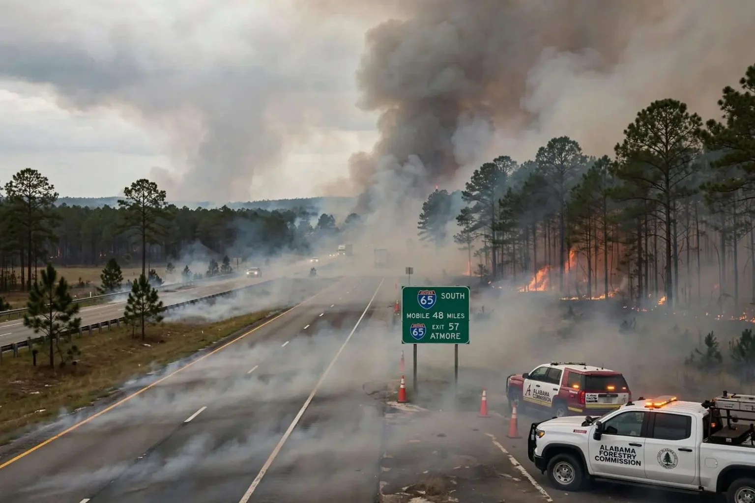
ESCAMBIA COUNTY, Ala. — A wildfire burning off Interstate 65 in Escambia County sent a heavy plume of smoke into the sky, visible for miles after a camera at Wind Creek Casino in Atmore captured the rising column. The Alabama Forestry Commission confirmed it was aware of the incident and said crews were looking into the blaze, while a journalist with the station contacted the commission’s media correspondent seeking more details on the fire’s size and source. Officials urged drivers in the area to use caution as smoke drifted across the interstate and reduced visibility near the highway. This article will be updated as more information becomes available.
Interstate 65 is the principal north-south artery through southwest Alabama, connecting Montgomery to Mobile and carrying heavy commercial traffic past the scattered communities of Escambia County. A wildfire near the corridor is more than a rural fire response: smoke that crosses the roadway at highway speed can reduce visibility in seconds, and fire departments must consider both the burning brush itself and the traffic hazard it creates. Wind direction determines everything in such incidents, since a fire burning on one side of the interstate can blind drivers on the other when conditions shift.
The fire environment in south Alabama
Escambia County sits in the longleaf pine country of south Alabama, a landscape of timber plantations, managed forests, cutovers and swampy lowlands along the Conecuh River. The region’s vegetation is fire-adapted, and landowners and the Forestry Commission burn thousands of acres under controlled conditions each year to reduce fuel loads and maintain the ecosystem. But the same forest that welcomes prescribed fire becomes hazardous in dry, windy spells, when lightning, equipment sparks, debris burns and arson can ignite wildfires that spread through thick undergrowth faster than crews can cut lines around them.
The Alabama Forestry Commission is the state agency charged with wildfire suppression on forestland, and its response typically begins with aircraft or observers locating the smoke column, followed by commission tractor-plow units cutting firebreaks and local volunteer fire departments protecting structures and roads. The commission tracks burn bans and wildfire danger ratings county by county, and during elevated fire weather it restricts or suspends burning permits statewide. Escambia County’s volunteer departments, like those across rural south Alabama, depend on that partnership when a brush fire outruns what a single department’s tankers and brush trucks can handle.
Smoke on the highway
Smoke is the hazard most likely to reach the public in a wildfire off an interstate. Visibility can collapse from miles to a few car lengths where the plume crosses the roadway, and the danger is sharpest in the early morning and evening, when smoke settles low and sunlight angle compounds the blindness. Law enforcement practice in such incidents includes posting warnings, slowing traffic, and closing sections of the highway when the smoke cannot be managed. Drivers who encounter smoke are advised to slow down, turn on headlights, keep windows closed and never stop in the travel lanes; a rear-end collision in smoke is among the most common wildfire-adjacent accidents.
Wind Creek Casino’s position in Atmore, just north of the county line, made its camera an accidental early-warning system, and in the social media era such views often spread faster than official updates. That speed has value and risk: residents and travelers get immediate notice of trouble, but unverified reports of a fire’s size and spread can outrun the facts. The Forestry Commission’s confirmation that crews were investigating, and its caution that details remained limited, was the accurate middle ground between alarm and reassurance while the incident was still being assessed.
Wildfires off Alabama interstates typically end one of two ways: crews contain them while they are still measured in acres, or wind and drought turn a brush fire into a multi-day incident with evacuated homes and closed highways. The response mounted after the smoke appeared over the pinewoods near I-65 was aimed firmly at the first outcome, and the urging of caution for drivers reflected the immediate public-safety priority. Updates followed as the commission and local departments established the fire’s size, cause and containment prospects.
Escambia County’s fire history is the backdrop for any blaze in its pine country. The county and its neighbors across the state line in Florida share the same forest type, the same rural volunteer fire structure and the same vulnerability to dry spells. Timber is the economic engine of the region, and a wildfire that sweeps through a plantation can wipe out a landowner’s investment in an afternoon, which is why the forestry community treats fire lines and controlled burns as routine business rather than emergency measures. The commission’s work in suppression is matched by its work in prevention: permit requirements, burn bans and public education all aim at keeping the accidental fire off the landscape in the first place.
The equipment involved in a rural wildfire response differs sharply from a house fire. Tractor-plow units cut firebreaks by plowing mineral soil around the perimeter, brush trucks carry water into rough terrain, and helicopters or fixed-wing aircraft drop water and observe fire behavior that ground crews cannot see. Volunteer departments coordinate through mutual aid, and in larger incidents the Forestry Commission assumes command of the suppression operation while local departments handle structure protection. Weather is the third actor in every account: humidity, wind and drought index readings determine whether a fire creeps through leaf litter or runs through crowns of standing pines.
How residents and travelers should respond
For residents near a wildfire, official guidance is consistent across incidents. Stay aware of wind direction, keep roofs and gutters clear of debris before fire season, and be ready to leave if smoke begins to settle into neighborhoods, since breathing wildfire smoke is hardest on children, the elderly and those with respiratory conditions. Vehicles should be moved away from grass and brush, and residents should not attempt to fight a spreading fire themselves; volunteer departments respond to these calls, and a homeowner with a garden hose between a running fire and the house is in the wrong place.
For travelers, the calculus is simpler. Smoke on the interstate means slow down or get off, and drivers should resist the instinct to continue at speed through reduced visibility with hazards blinking on the shoulder of the highway. Alabama’s law enforcement agencies coordinate with the Forestry Commission on road management during wildfire incidents, and closures or detours are announced through highway advisory radio, message boards and local media. An interstate closure is an inconvenience measured in minutes; a multi-vehicle collision in smoke is a tragedy measured in lives, and the choice between them is made by each driver as the plume crosses the road.
The fire off Interstate 65 in Escambia County, caught in its opening hours by a casino camera and confirmed by the state’s forestry agency, unfolded in a region that knows the drill. Crews looked into the blaze, officials warned drivers, and the story remained open as the facts arrived. That is the normal rhythm of wildfire news in south Alabama’s pine belt, where smoke on the horizon is a seasonal fact of life and the difference between a small fire and a big one is usually written in the weather.
The longleaf pine ecosystem that dominates Escambia County is, in ecological terms, a fire landscape that humans have managed with fire for thousands of years. Longleaf forests burn naturally every few years, and the trees, along with the wiregrass ground cover and the wildlife they shelter, from gopher tortoises to red-cockaded woodpeckers, depend on periodic fire to reproduce. Modern suppression changed that rhythm for decades, allowing fuel to accumulate, and the region’s current practice of frequent prescribed burning is the restoration of an old pattern. A wildfire like the one off I-65 thus unfolds on land where fire is both the ancient order and the modern emergency, depending on who set it and when.
Prescribed burns are conducted under strict weather prescriptions, when humidity and wind allow fire to consume the undergrowth without damaging the overstory or escaping control lines. Escapes are rare but publicized, and they fuel a recurring tension in rural Alabama between the forestry establishment’s use of fire and residents’ memory of the burns that got away. The Forestry Commission’s permit system exists to manage that balance, and its seasonal burn bans, imposed when drought indices rise, are the clearest signal the public gets about how combustible the landscape has become. Weeks of dry weather can transform a county that burns safely in February into a county where every spark matters by late spring.
The people who fight these fires
The response to any wildfire in Escambia County rests on the volunteer fire service that protects most of rural Alabama. Small departments with limited budgets field brush trucks and tankers, and their members leave jobs and families when the tones sound. The Forestry Commission’s career crews and equipment provide the backbone of forest suppression, but the first engine on most scenes belongs to a volunteer department, and the cooperation between the two systems is one of the quiet institutional successes of rural Alabama public safety. County emergency management agencies round out the structure, coordinating road closures, shelter decisions and public messaging when an incident grows.
Accountability for wildfire causes runs through the commission’s investigative process as well. Debris burns that escape permits, equipment that throws sparks in dry grass, and deliberately set fires all carry civil or criminal exposure, and the cause determination that follows containment feeds back into prevention enforcement. In a county where timberland is the principal asset for many families, a fire’s cause is not an academic question; it determines who answers for the lost acres. That backdrop of accountability shapes how seriously rural landowners take the permit calls and weather checks that precede every legitimate burn.
The smoke column that rose over the pines off Interstate 65 passed through all of this machinery in its first hours: a camera noticed, the commission confirmed, crews investigated, drivers were warned, and the incident moved onto the record of Escambia County fires, large or small as the facts ultimately showed. For the region’s residents it was a familiar sequence, and for travelers on the interstate it was the latest reminder that Alabama’s forests are never far from the pavement, and that the fire season is never entirely over.