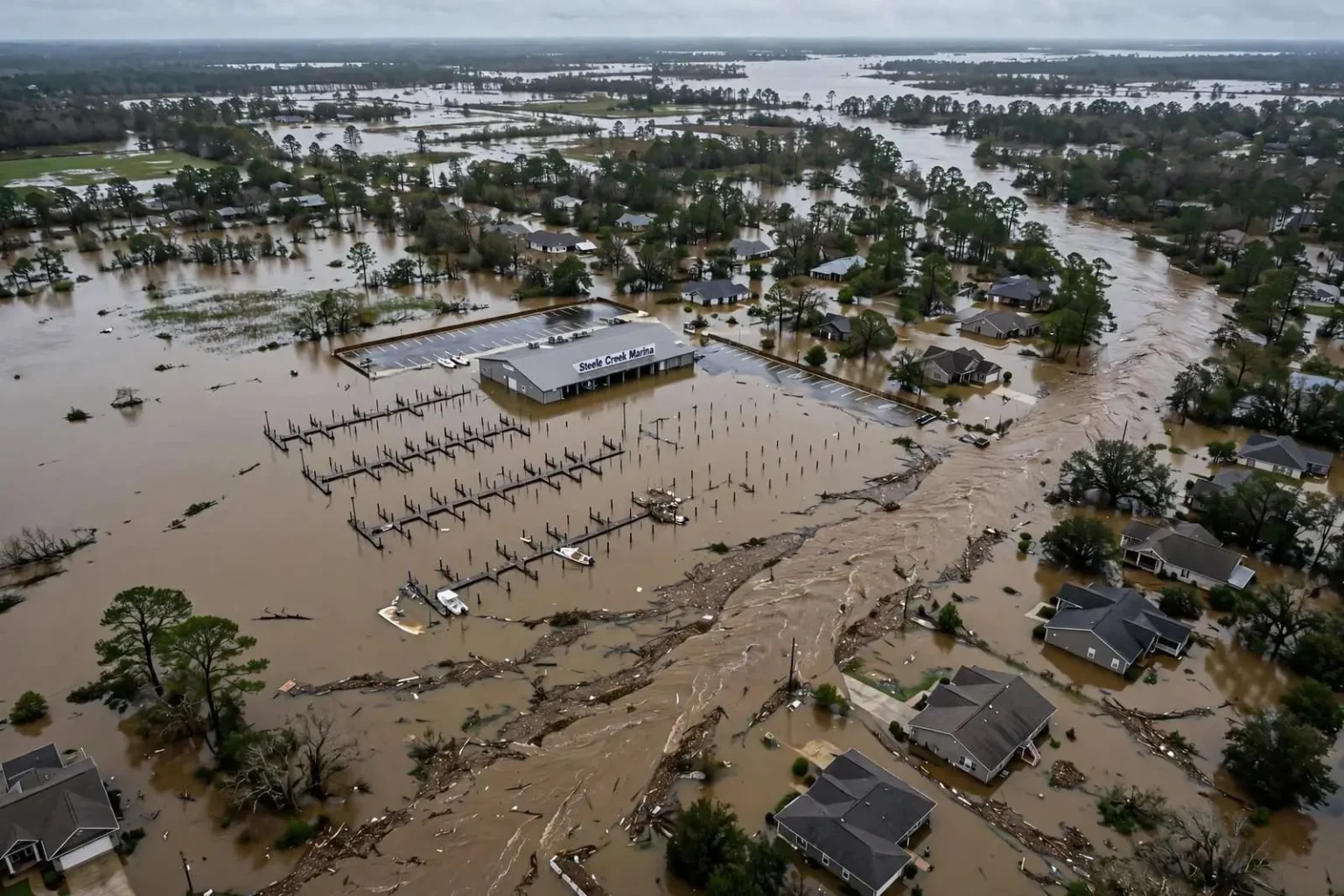
Aerial footage captured the extent of flooding at Steele Creek Marina in Satsuma after days of heavy rain drenched north Mobile County, with video showing most of the marina property already under water. The drone video, recorded as the floodwaters reached their peak in the area, showed docks, shoreline, and low-lying portions of the marina grounds disappearing beneath a wide expanse of brown water that had swallowed nearly every inch of the property not sitting on higher ground.
The drone footage also made clear how dangerous conditions had become on area roads. Water could be seen completely overtaking the roadway near the marina, leaving it impossible for drivers to pass through. What normally functions as an ordinary access route to a popular recreation spot had been transformed into a stretch of moving water with no visible pavement and no way to judge its depth from behind the wheel — exactly the scenario emergency managers warn about when heavy rain repeatedly falls on already saturated ground.
Flooding did not stop at the Satsuma city limits. The same photographer, Chris Jessee, took pictures along Bayou Sara Avenue in nearby Saraland. Those images showed flooded streets, with standing water pressing against several homes in the low-lying corridor between the two cities. In some spots the water reached driveways and yards; in others it crept close enough to porches and garages that residents kept watch as the creek continued to rise through the day.
Why this corridor floods first
The geography of the area explains why these neighborhoods are among the first to take on water. Steele Creek flows through southern Saraland before reaching the Spanish River and Mobile Bay, and neighborhoods around the marina and Bayou Sara Avenue sit at low elevations that are vulnerable when sustained rainfall pushes creeks and bayous out of their banks. When upstream sections of the watershed drain southward, water funnels through this narrow, flat corridor between Satsuma and Saraland faster than the ground and channels can absorb it.
That pattern is familiar to residents of north Mobile County. The land between Saraland, Satsuma, and Creola is laced with small creeks and bayous that drain toward the Spanish River and, ultimately, Mobile Bay. Much of the terrain is flat and low, and development over the decades has put homes and roads in close proximity to those drainage channels. In ordinary rain events the creeks stay within their banks; when several rounds of heavy storms fall within a matter of days, the system has nowhere left to put the water and the low spots flood first.
February 2020 was an exceptionally wet month along the central Gulf Coast, with repeated rounds of thunderstorms saturating ground already soaked from prior rains. Rather than a single destructive storm, the flooding developed from the cumulative effect: day after day of downpours that left no time for the soil to dry, the ditches to empty, or the creeks to drop back to their normal levels. Each new round of rain arrived on ground that could absorb almost nothing more, so runoff poured directly into streams, streets, and yards.
Forecasters with the National Weather Service office serving the Mobile area repeatedly emphasized that risk during wet stretches like this one. When the ground is saturated, storms that would normally produce only minor street ponding can instead produce significant flooding of creeks, low-water crossings, and neighborhoods near drainage channels. That is what played out at Steele Creek, where the water level reflected not just one day of rain but the accumulated runoff of an entire soggy stretch of winter weather.
The marina and the community around it
Steele Creek Marina is a well-known spot for boaters and anglers in the area, providing access to the creek and the broader Mobile-Tensaw delta system beyond it. Properties like the marina sit close to the water by design, which makes them popular destinations in fair weather and among the most flood-exposed sites in the county when the water rises. Aerial imagery of the flooded grounds offered a striking visual of just how quickly a functioning marina can be rendered unusable by days of rain.
For residents along Bayou Sara Avenue and the surrounding streets, the pictures from the air confirmed what they could see at ground level. Standing water pressing against several homes is among the most stressful sights a homeowner can face, and events like this one renew longstanding local conversations about drainage maintenance, culvert capacity, and how development in the watershed affects the flow of stormwater through the corridor between the two cities.
City and county road crews in communities like Satsuma and Saraland routinely respond to flooding by closing affected roads and placing barricades at low-water crossings. Those closures are meant to prevent exactly the kind of situation the drone footage captured: a roadway so completely overtaken by water that drivers cannot tell where the pavement ends. Officials stress that a closed or flooded road is never worth the risk of crossing, no matter how familiar the route or how short the detour around it might seem.
The danger of flooded roads
Officials routinely urge drivers never to attempt to cross flooded roadways, since water depth is difficult to judge and a foot of moving water can carry away most vehicles. The guidance, promoted nationally under the slogan “Turn Around, Don’t Drown,” exists because flooded-road deaths remain among the most common weather-related fatalities in the United States year after year, and the Gulf Coast sees more than its share during extended rainy periods.
The physics behind the warning are simple. Water adds weight and buoyancy at the same time: just a foot of moving water pushes against a compact car with enough lateral force to sweep it off the road, and two feet can carry away larger vehicles, including SUVs and pickups. Hidden hazards compound the danger — washed-out pavement beneath the surface, submerged debris, and downed power lines can all lurk under water that looks shallow and slow. Drivers who enter flooded roads also put rescuers at risk, since every water rescue requires emergency crews to enter the same conditions.
Emergency managers recommend a handful of precautions whenever prolonged heavy rain is in the forecast. Residents in low-lying areas are encouraged to move vehicles to higher ground before water reaches street level, to keep storm drains and ditches near their property clear of debris, and to have a plan for moving valuables out of flood-prone garages and ground-floor rooms. Checking on elderly neighbors, keeping phones charged, and knowing which routes out of a neighborhood stay above water are all steps that make a measurable difference when creeks begin to rise.
Homeowners’ insurance policies generally do not cover flood damage; separate flood insurance through the National Flood Insurance Program is required for that protection, and properties in low-lying corridors like the area around Steele Creek and Bayou Sara Avenue fall squarely within the kind of zones where agents recommend it. Because standard flood policies typically carry a waiting period before coverage takes effect, officials urge residents not to wait until a wet pattern is already underway to consider their coverage.
Monitoring tools available to residents have expanded in recent years. The National Weather Service Mobile office issues flood watches and warnings for Mobile County and posts real-time rainfall and stream gauge information online, while county and municipal emergency management agencies share road closure information on social media during events. Local rainfall totals can vary dramatically over short distances during thunderstorm-driven rains, so officials advise residents to rely on official gauges and warnings rather than on conditions observed at their own homes.
Watching as more rain moved in
Residents in flood-prone sections of Satsuma and Saraland were advised to monitor conditions as more rain moved through the region. With the ground saturated and creeks already running high, even moderate additional rainfall had the potential to prolong the flooding or push it into areas that had avoided the worst of the first rounds. Emergency officials asked residents to report blocked drainage and rising water and to stay clear of barricaded streets while crews worked.
The aerial images of Steele Creek Marina under water served as a reminder of how the central Gulf Coast experiences its wettest stretches. Unlike hurricane storm surge, which arrives with a named storm and days of warning, or a single violent tornado, riverine and flash flooding builds gradually, neighborhood by neighborhood, as the water table rises and the creeks creep toward their banks. By the time the water is lapping at homes along Bayou Sara Avenue, the decisions that matter — where to park the car, whether to drive through that low spot, whether to move valuables upstairs — have usually already presented themselves.
For the communities along the Steele Creek corridor, the event joined a long local history of high-water episodes in the low country between the Mobile-Tensaw delta and Mobile Bay. The same geography that makes the area scenic and attractive to boaters — abundant water, low terrain, and proximity to the delta — is what puts streets and homes at risk when the rains will not stop. As the drone footage showed, the creek and the community share the same narrow strip of land, and in a wet February the creek takes the larger share.
Officials continued to emphasize the same core messages as the water slowly receded: never drive through a flooded roadway, keep children away from floodwater, and remember that receding water leaves behind hazards of its own, from slick mud and debris to contaminated runoff. Residents were encouraged to photograph any damage they sustained for insurance purposes and to check on neighbors along the flooded corridors as cleanup began. For now, the images from above offered the clearest picture yet of just how much of the marina property and the surrounding low-lying streets the creeks had claimed during the extended wet stretch.