ALDOT Wants Local Voices in the Road Plan That Will Shape Mobile and Baldwin Through 2050
Alabama transportation officials held a public open house in Mobile as they update the state's long-range plan through 2050, with Baldwin County growth a central concern for future road funding.
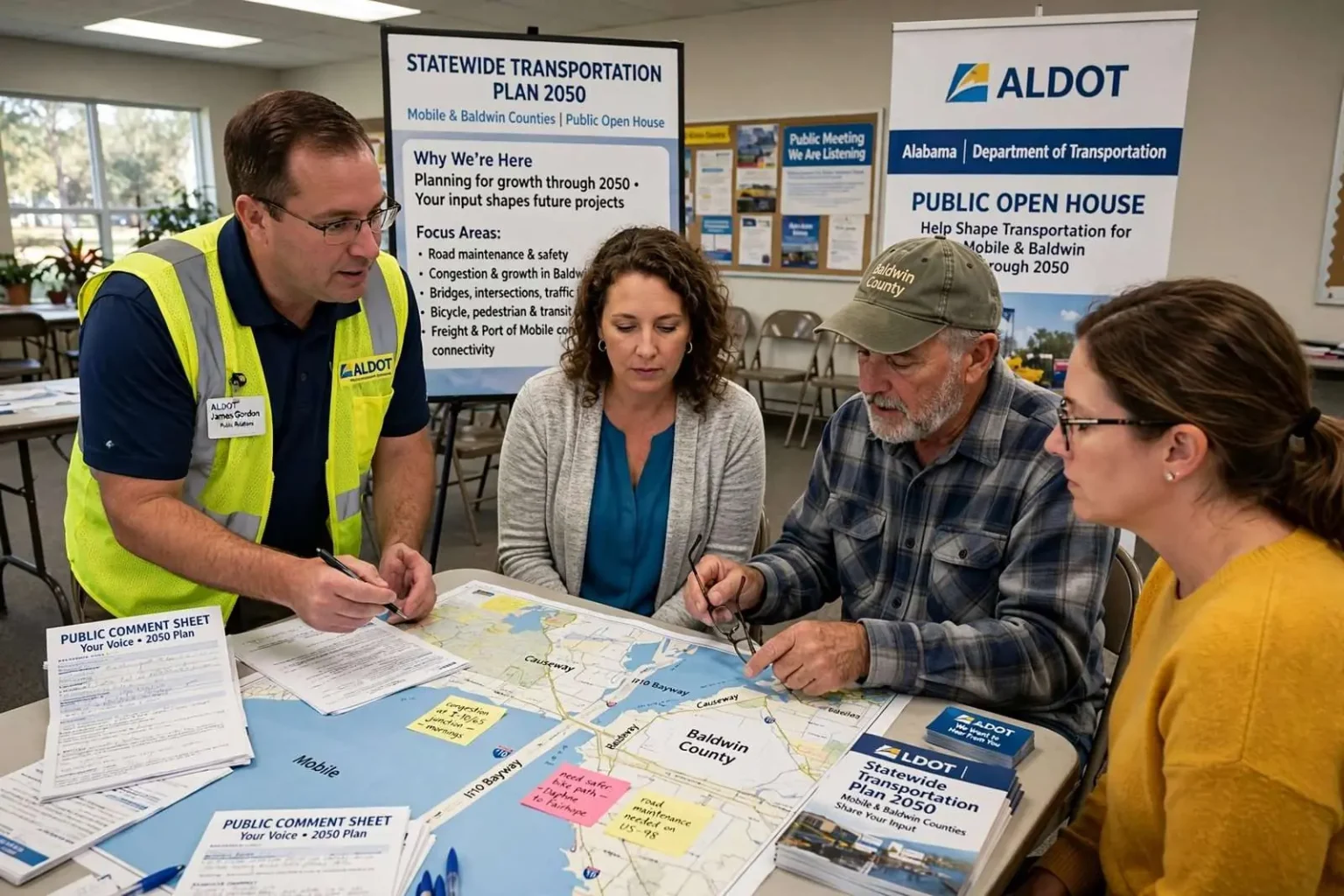
State transportation officials are looking a quarter-century down the road, and they say what residents of Mobile and Baldwin counties tell them now will help determine which projects get built later. The Alabama Department of Transportation recently hosted a public open house in Mobile as part of its update to the Statewide Transportation Plan, a long-range document that evaluates the state’s transportation needs through 2050 and guides future investment decisions.
What the Plan Actually Does
The Statewide Transportation Plan is not a construction schedule. It is a roadmap — an assessment of Alabama’s multimodal transportation network that includes highways, bridges, transit, rail, freight, airports, waterways, bicycle infrastructure and pedestrian facilities. It identifies priorities as population and travel patterns change, but does not by itself authorize any specific project.
What it does do is control the door. As a transportation planning consultant working with ALDOT explained, the plan is a federal requirement, and the requirement has teeth.
“In order to get federal funding to do large transportation projects, you have to have a plan, and the projects have to be listed in the plan,” the consultant said.
In practical terms: a project that never makes it into the long-range plan is a project that cannot draw major federal dollars. For a fast-growing coastal region with expensive infrastructure needs, that is not a technicality.
The arithmetic matters most at the federal level, where large highway and bridge projects routinely draw the majority of their cost from Washington. A widening project on an interstate corridor, or a new crossing over Mobile Bay, can cost hundreds of millions of dollars — sums no local government carries alone. Whether such a project appears in the plan is therefore not a paperwork step; it is the difference between a project that can be funded and one that exists only on a wish list.
What Residents Told Them
James Gordon, communications and public relations coordinator for ALDOT, said officials were pleased with the turnout at the open house.
“We had a good mix of residents, community leaders and stakeholders who took the time to learn about the Statewide Transportation Plan and share their thoughts,” Gordon said. “That’s exactly what these meetings are for — listening to the people who use Alabama’s transportation system every day.”
The themes that surfaced will sound familiar to anyone who drives the region: Maintenance first — keeping existing roads and bridges in good condition. Congestion tied to population growth. Safety, consistently a top concern. Connectivity and intersection improvements. Walking and bicycling options where appropriate.
Gordon argued that public comment fills a gap that technical analysis cannot.
“We can study traffic counts, population trends and roadway conditions, but the people who drive these roads every day often provide valuable insight that data alone can’t capture,” he said.
The open-house format itself is part of how federal planning law works. Metropolitan planning organizations and state DOTs are required to give the public genuine access to long-range planning — not merely notice after decisions are made — and ALDOT’s decision to carry the update through a series of public sessions rather than a published draft alone reflects that obligation. For Mobile and Baldwin residents, the meeting was the rare moment when commenting on a statewide document translated directly into the funding pipeline for their own commutes.
A traffic counter can record that an arterial backs up at 7:40 each morning; it cannot record that drivers reroute through neighborhood streets to avoid it, or that an intersection’s left-turn signal creates the hazard residents report most. Those details — the ones commuters carry with them — are what open-house comment sheets collect, and planning agencies have learned to treat them as data of their own kind.
Baldwin County’s Growth Problem
The region’s central transportation challenge is not subtle. Baldwin County is one of the fastest-growing counties in Alabama, and its road network was largely designed for a smaller population and a lighter seasonal load.
Gordon said ALDOT is coordinating with regional planning organizations and local governments to prepare.
“Baldwin County is one of the fastest-growing areas in Alabama, and we’re planning for that growth by working closely with the Eastern Shore Metropolitan Planning Organization, local governments and our legislative delegation,” he said. “Our shared goal is to improve safety, reduce congestion and keep people and goods moving efficiently as the county continues to grow.”
Future improvements could include roadway widening, intersection upgrades, new bridges and operational improvements, depending on local priorities and available funding.
The planning consultant described the exercise as forecasting where the pressure will land.
“We’re looking out about 25 years, and we’re looking at what’s going to be needed based on where growth is happening, where new neighborhoods are coming in or new industries, and then also where things are changing,” the consultant said.
The Baldwin picture behind those words is one any Eastern Shore commuter can sketch: subdivisions climbing the county’s northern tier, beach traffic stacking up on summer weekends, and a commuter flow that funnels onto a handful of crossings — the Causeway, the I-10 bayway and its tunnels — every weekday morning. A road grid drawn when Baldwin was farm country now carries a suburban county of well over two hundred thousand people, plus the tourists its beaches attract by the millions each year.
Baldwin’s growth curve has reshaped the county’s politics as well as its roads. Each round of new subdivisions brings new voters whose priorities — schools, commute times, sewer capacity — differ from those of long-established communities along the bay, and the county’s planning fights increasingly run along that line. The statewide plan’s 2050 horizon sits at the far end of the same argument: whichever growth pattern Baldwin follows in the next two decades will decide whether its transportation network bends or breaks.
The plan’s multimodal scope also matters in a way the highway-first history of the region obscures. Transit service in the two-county area remains thin — the Wave operates Mobile’s buses, while Baldwin’s communities have largely gone without fixed-route transit — and the plan’s treatment of transit, rail, and bicycle and pedestrian facilities is where those gaps either enter the pipeline or stay out of it. Commenters who raised walking and bicycling options were therefore speaking to a document that can, at minimum, make such projects eligible for the federal programs built for them.
Why South Alabama Has an Unusual Stake
Few regions in the state have as much riding on long-range transportation decisions. The Mobile-Baldwin corridor carries the freight moving in and out of the Port of Mobile, the industrial traffic serving the region’s manufacturing and aerospace employers, and the seasonal surge of visitors headed for the beaches. Bridges over Mobile Bay, the interstate corridors and the north-south highways that feed the coast all operate under strain that intensifies with each year of population growth.
The Port of Mobile’s expanding container terminal has raised the stakes further. Container traffic multiplies truck movements on the same corridors commuters use, and the port’s growth — already among the South’s busiest deep-water terminals — ties Mobile’s economic future to road and rail capacity that must be planned years before the volumes arrive. Industrial employers along the Mobile River and the Outokumpu mill in Calvert add their own freight to the same map.
The Eastern Shore Metropolitan Planning Organization handles the Baldwin County side of that equation, coordinating with municipalities from Daphne to Fairhope to Spanish Fort. Its work — and the projects it advances — ultimately has to align with the statewide plan to compete for the largest pots of money.
That alignment rule is what gives the statewide planning process its practical force on the local level. A Baldwin municipality’s preferred intersection fix, or a regional bridge proposal, enters the federal funding pipeline only after it appears in the metropolitan plan and the statewide plan — a chain of documents stretching from a city council’s wish list to the federal programs that finance the work. Residents commenting at an ALDOT open house are therefore commenting, in effect, on the first link of that chain.
How to Weigh In
Gordon said the next step is combining public comments with technical analysis, traffic data, population forecasts and input from transportation partners before the updated plan is finalized. Comments collected through public meetings, surveys and online feedback will all be reviewed.
“We encourage residents to continue providing feedback through our website as the planning process moves forward,” Gordon said. Residents can submit comments through ALDOT’s website while the plan remains open for input.
For residents weighing whether a comment on a 25-year plan is worth the trouble, ALDOT’s answer was embedded in the process itself: the plan that emerges from this round of meetings will be the document every large project in the region has to appear in for the next planning cycle. The roads Baldwin and Mobile will drive in 2050 — the widenings, the crossings, the intersections fixed and unfixed — begin their official lives not at a construction site but on a comment sheet collected at a folding table in Mobile.