University of South Alabama Mobile
Archaeologists Race the Clock as I-10 Mobile River Bridge Site Prep Begins
As demolition clears the footprint for the future Interstate 10 Mobile River Bridge, University of South Alabama archaeologists are racing to document centuries of history buried near downtown Mobile before construction begins.
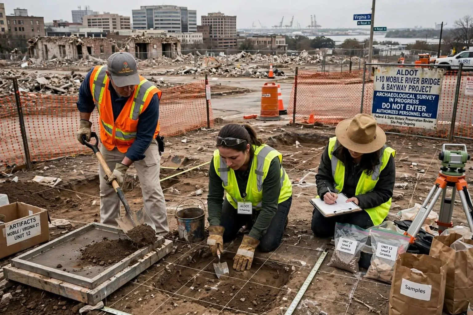
Ahead of construction on the long-planned Interstate 10 Mobile River Bridge and Bayway project, teams of archaeologists have been combing through a stretch of downtown Mobile near Virginia Street, examining ground that will soon be cleared for the massive span’s footings. The work is a standard but often overlooked phase of major highway projects: before heavy equipment moves in, state and federal review requires a look at what history may lie in the soil, and downtown Mobile sits on some of the deepest layers of history in Alabama.
The Alabama Department of Transportation has spent recent months tearing down nine buildings within the project’s footprint just south of downtown, the first visible phase of a project that has been discussed for years but is now inching toward reality. The demolitions mark the transition from paperwork to machinery on a project that will ultimately rebuild one of the region’s most congested corridors, and they have redrawn a block of near-downtown streetscape where offices and small businesses stood for decades.
Because the bridge’s final engineering design is still being finalized, officials say they cannot yet pinpoint the exact locations where the structure’s footings will be placed, so the demolition and archaeological review are being carried out across a broader area than the bridge will ultimately occupy. The broader sweep protects against surprises: if historical material turns up anywhere in the wider corridor, the state has room to adjust the design without starting the review over. It also means some cleared ground will never host a footing at all, a cost of building carefully in a historic port city.
How the Acquisitions Played Out
Some of the nine buildings sat vacant before the state acquired them. Others held active businesses and offices whose owners and tenants were asked to relocate. State officials describe the acquisition process as lengthy, but say affected property owners were compensated at fair market value. Right-of-way acquisition on a project of this scale unfolds over months and sometimes years, with appraisals, negotiations, offers and relocations handled by ALDOT specialists following federal procedures that apply because the bridge is a federally aided project.
One of those tenants, attorney Jason Darley, moved his practice out of a building in the project area earlier this year, eventually relocating to North Lawrence Street. Darley said the process took shape gradually, beginning six to eight months before he actually left, after right-of-way specialists laid out a timeline for the move that he found largely accurate. “I was pretty happy with the process, but I’m not an owner,” Darley said. “I talked with people who planned the project and they told me it was a ‘when’ not an ‘if.’ I was surprised when they said it was really happening.”
Darley said leaving the building was bittersweet. “There is some sentimental value in it, of course,” he said. “It was a beautiful building and I enjoyed being there.” His account matches what relocation specialists aim for on federally funded projects: early notice, a realistic schedule and a predictable sequence of steps. For a tenant, the process means moving an established practice on someone else’s timeline, but Darley’s experience suggests the state kept to the schedule it promised.
What Lies Beneath Downtown Mobile
Once a building comes down, archaeologists move in to examine what lies beneath before any further site work begins. Mobile is one of the oldest continuously settled cities on the Gulf Coast, founded by the French in 1702 and successively held by the French, British, Spanish and Americans before joining Alabama. Three centuries of occupation have left the downtown ground layered with foundations, wells, cisterns,privies, refuse pits and artifacts from every era, and the area near Virginia Street sits close to some of the city’s earliest built-up blocks.
The archaeological review follows federal historic preservation law, which requires identification and evaluation of significant historical and archaeological resources before federally funded construction disturbs them. Teams typically dig systematically placed test units, screen the soil for artifacts, and document any features they find. Depending on what emerges, the state may adjust designs to avoid significant sites, or conduct data recovery — careful excavation and documentation — where avoidance is impossible. The process adds time and cost to a project, but it is required before the first footing hole can be dug.
In a city like Mobile, the potential findings range from French and Spanish colonial material to nineteenth-century commercial deposits and artifacts of the city’s antebellum and industrial eras. Any recovery would add to the documented record of a city whose early history is among the most complex on the Gulf Coast.
The Bridge and Bayway Project Itself
The Mobile River Bridge and Bayway project has been in planning for more than a decade as the answer to chronic congestion on the Wallace Tunnel portion of Interstate 10, where cross-river traffic from the Bankhead Tunnel and Wallace Tunnel funnels into a two-lane bottleneck used by local commuters and heavy freight traffic alike. The plan calls for a new cable-stayed bridge over the Mobile River east of downtown, a rebuilt and widened Bayway across Mobile Bay, and a tolling system to help finance construction.
The project is among the largest transportation undertakings in Alabama history, with an estimated cost in the billions of dollars. State officials have described it as necessary for both mobility and freight movement: the Port of Mobile’s container terminal has expanded rapidly, and the corridor carries a growing share of Gulf Coast commerce. Public debate over the project has centered on tolling — how much drivers will pay, whether local commuters will be exempted, and how the revenue will be split between the bridge and the Bayway — and those policy questions have run alongside the engineering and environmental reviews now visible on the ground.
What Residents Will See Next
The demolition of the nine buildings is the most visible sign so far, but the sequence that follows will unfold gradually. Archaeological fieldwork proceeds on the cleared parcels while final design continues. Utility relocations — moving water, sewer, gas and communications lines out of the footprint — typically follow or run in parallel, because utilities must be out of the way before structural work begins. Construction of the bridge itself, once design and contracts are complete, will proceed from foundations upward, a process expected to take years.
For neighbors of the project area, the changes are already tangible. A block that held offices and businesses for decades is now cleared ground, and the near-downtown streetscape around Virginia Street has visibly changed. Traffic patterns in the area will be managed through construction phases as work advances, and ALDOT typically publishes schedules and lane closures as each stage nears.
A Corridor Decades in the Making
Interstate 10 is the principal east-west artery of the Gulf Coast, connecting Mobile to Pensacola on one side and Mississippi on the other, and it is the route nearly all cross-bay and cross-river traffic must take. The current crossings — the Bankhead Tunnel into downtown and the George Wallace Tunnel under the river — were built in the mid-twentieth century for a city and a traffic load that no longer exist. Peak-period backups through the tunnels are routine, and freight traffic to and from the port, the Alabama State Docks and the growing container terminal shares the same two lanes as daily commuters.
Planning for a new crossing began in earnest in the 2000s, and the Mobile River Bridge and Bayway has since advanced through environmental study, preliminary engineering, financing design and right-of-way acquisition. The tolling component, adopted as the financing mechanism, has remained the project’s most controversial element, prompting public hearings and, at one point, legislative attention to how tolls would be set and whether local drivers would be exempted. ALDOT has maintained that the toll revenue is necessary to fund construction at the necessary scale.
The demolitions near Virginia Street show the project moving from the study phase into the physical one. For ALDOT, each cleared parcel and each completed archaeological review is a milestone in a timeline that will stretch for years. For downtown Mobile, the eventual result will be a new span rising over the river and a rebuilt Bayway carrying what is projected to be decades of regional growth in traffic, freight and population.
The Archaeology’s Deeper Stakes
Mobile’s archaeological record is unusually rich for an American city because of its long, layered colonial history. The original French settlement site at Twenty-Seven Mile Bluff on the Mobile River, the later colonial town, and the American-era commercial district each left distinct material signatures. Archaeological work in and around downtown has previously recovered colonial ceramics, military artifacts, and deposits from the cotton and steamboat eras. A systematic review of the Virginia Street area — before it is permanently disturbed by bridge footings — is likely to add to that record regardless of what is found, since negative findings themselves are documented evidence of what the ground does and does not contain.
The state’s approach also reflects lessons learned on other Gulf Coast projects, where construction in historic districts has required careful sequencing between demolition, archaeology and foundations. By reviewing a wider area than the final footprint, ALDOT gives its archaeologists the chance to identify sensitive zones while the design can still move around them — a flexibility that vanishes once footings are cast.
From ‘When, Not If’ to Steel in the Ground
Darley’s recollection of being told the project was a “when, not an ‘if'” captures the long wait Mobile has put into this corridor. Successive administrations, transportation directors and civic groups have promoted the bridge since the tunnels’ congestion became a regional economic concern. The visible progress — buildings down, archaeologists in, design advancing — is what the “when” looks like at ground level.
What remains ahead is the hard middle of the project: final design decisions, contract awards, utility relocations, archaeological recoveries, and then construction itself. None of it will be quick, and none of it will be quiet. But the sequence now underway — demolition, archaeological review, and ultimately footings — is the standard path every major bridge takes between promise and steel, and Mobile’s is finally on it.
Residents and businesses in the project area can expect continued periodic notices from the state as acquisition, archaeology and design advance, and the downtown skyline near the river will change gradually as the project’s early works appear. For now, the nine empty parcels near Virginia Street are the clearest evidence that after years of study, the Interstate 10 Mobile River Bridge and Bayway is no longer only a plan.