Gulf Coast Forecast: Scattered Storms and Cooler Days Ahead as Tropical Storm Dolly Forms Far Out at Sea
Scattered showers and storms stay in the Gulf Coast forecast through the weekend with highs in the upper 80s, while Tropical Storm Dolly churns far out in the Atlantic.
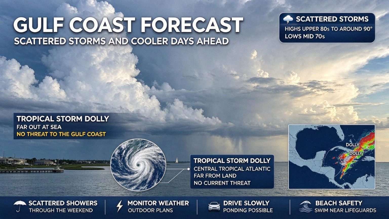
MOBILE, Ala. — After Thursday’s rounds of rain and thunderstorms, the Gulf Coast stays unsettled today with scattered showers and storms in the mix. The good news: temperatures should stay far more manageable than last week’s extreme heat, generally topping out in the upper 80s to around 90 degrees across Mobile, Baldwin County and the rest of the central Gulf Coast.
The pattern is a familiar one for late August along the northern Gulf Coast: morning sunshine, afternoon heating, and storms that build through the afternoon before fading after sunset. If residents can plan outdoor activities for the first half of the day, the odds of staying dry are much better than waiting until after the afternoon convective showers get going. Beachgoers heading to Gulf Shores, Orange Beach or Dauphin Island will find the morning hours the most comfortable for swimming, with water temperatures still warm from midsummer.
Weekend: Daily Rain Chances
The weekend remains unsettled, with scattered showers and thunderstorms in the forecast both Saturday and Sunday across the Mobile-Pensacola area. It will not rain all day, and there will still be some dry breaks, but anyone with outdoor plans should keep rain gear handy. High temperatures should remain in the mid to upper 80s, with overnight lows only dropping into the mid-70s thanks to high humidity streaming in off the Gulf of Mexico.
Lightning is the primary severe-weather concern with these pulse-type summer storms. Forecasters urge boaters on Mobile Bay, swimmers along the public beaches in Gulf Shores and Orange Beach, and youth football and soccer practices across the region to monitor radar and head indoors at the first sign of thunder. Brief, heavy downpours can also reduce visibility on Interstates 10 and 65 in a matter of minutes, and the Alabama Department of Transportation reminds drivers never to attempt to cross a flooded roadway.
Saturday’s rain coverage is expected to be a bit more widespread than Sunday’s, with the highest chances for showers and storms arriving along and east of Interstate 65 during the afternoon hours. Anyone with tickets to one of the many high school football jamborees being held across south Alabama this weekend should be ready to wait out a delay or two, and the Mobile BayBears’ promotional schedule and other outdoor community events will be at the mercy of radar.
Next Week: Typical Late-Summer Weather
Scattered showers and thunderstorms will remain in the forecast into early next week, with temperatures gradually warming back toward 90 degrees. So while the extreme heat is gone for now, the familiar combination of heat, humidity and afternoon storm chances is not going anywhere as the calendar heads toward Labor Day weekend.
The break from triple-digit heat indexes comes as a relief across Mobile, Baldwin County and the rest of the central Gulf Coast, where last week’s heat pushed outdoor work, construction crews, and school activities into the early morning hours. Cooling centers and splash pads have seen heavier use this month, and several school districts moved afternoon practices to early morning to keep student-athletes safe during the hottest stretches.
Utility providers across the region reported record or near-record demand on the electric grid during the hottest afternoons last week, with Baldwin County EMC and Alabama Power both asking customers to set thermostats a few degrees higher between 3 and 6 p.m. Conservation pleas are expected to ease somewhat over the coming week, but residents are still being reminded to check on elderly neighbors and to keep pets indoors during the hottest part of the day.
Dolly Forms in the Tropical Atlantic
The Atlantic is getting a little more active. Tropical Storm Dolly has formed in the central tropical Atlantic, becoming the fourth named storm of the 2026 Atlantic hurricane season. Dolly is currently far from land and poses no threat to the Gulf Coast, the Caribbean islands or the U.S. mainland at this time. The storm’s center is well east of the Lesser Antilles and is expected to track over open water for at least the next several days.
Dolly is expected to move generally westward over the next several days, but environmental conditions — including stronger upper-level wind shear and drier mid-level air — are forecast to become less favorable, and the storm may weaken over the coming days. Even so, the system’s deep tropical moisture could eventually bring heavy rain to parts of the northeastern Caribbean, including portions of the Lesser Antilles, regardless of whether Dolly remains a named storm.
The 2026 Atlantic season got off to a relatively slow beginning despite an active preseason forecast from the National Oceanic and Atmospheric Administration. Storm names through the first half of the list include Andrea, Barry, Chantal and Dolly. Forecasters have stressed that the headline number of named storms matters less than whether any of those systems make landfall at hurricane strength in vulnerable areas.
Why the Timing Matters
There are no concerns for the Mobile-Pensacola area at this time, but Dolly’s formation is a reminder that the season is entering its historically busiest stretch. The peak of the Atlantic hurricane season falls around Sept. 10, and the majority of named storms in a typical year form between mid-August and mid-October. Forecasters and emergency managers across coastal Alabama use this window to urge families to review hurricane plans, restock supply kits and confirm evacuation routes.
Mobile County and Baldwin County emergency management agencies are using the relatively quiet stretch to test generator readiness, review shelter locations and update reverse-911 contact lists. Residents who have moved into the area since the last major evacuation are reminded to register for local emergency alerts and to learn which side of I-10 their home and workplace sit on, since that determines which direction they would be asked to travel in the event of a major storm.
Local emergency officials in Mobile and Baldwin counties continue to stress that even a weakening tropical storm well east of the Gulf can shift the weather pattern across the northern Gulf Coast by increasing rain chances and swells, and that residents should keep close tabs on the official National Hurricane Center forecast products through the next several weeks. The Hurricane Hunters, based at Keesler Air Force Base in Biloxi, are also expected to begin more routine storm reconnaissance missions as activity ramps up.
What to Watch Locally
For now, the local forecast is all about timing outdoor plans around scattered storms. Keep an umbrella nearby, watch for lightning when storms build, and expect more of the same steamy, stormy pattern as the calendar turns toward September. Drivers should be alert for street flooding during the heaviest afternoon downpours, especially in low-lying parts of downtown Mobile and along the usual trouble spots on Government Street, Dauphin Island Parkway and the I-10 Bayway.
Forecasters will continue to track Dolly’s progress in the open Atlantic over the coming days and update the local forecast as needed. Residents who have not already done so can use the lull between Dolly and the next potential system to make sure phone alerts are turned on, gas tanks are kept at least half full during peak season, and important documents are stored in a waterproof container.
Beach safety remains a separate concern. The National Weather Service in Mobile reminds visitors and residents that even on a “green flag” day, longshore currents and the risk of rip currents can change quickly. Anyone entering the surf at public beaches in Gulf Shores, Orange Beach, Fort Morgan or Dauphin Island is urged to swim near a lifeguard and to know how to escape a rip current — relax, float, and swim parallel to shore until clear of the pull.
For gardeners, farmers and backyard growers across south Alabama, the weekend rain is a mixed blessing. Adequate rainfall has kept most yard irrigation systems idle this month, but the frequent bursts of heavy rain have also washed nutrients out of vegetable beds and caused some localized fungal problems on tomatoes, peppers and squash. Light pruning and a dry stretch in early September will be welcome medicine for the soil.
Tides along Mobile Bay will continue to run near seasonal averages, but onshore flow ahead of any developing Gulf system could push water levels higher and slow the outgoing tide in the bayous and backwaters. Anglers working the jetties at Dauphin Island and the public fishing pier at Gulf State Park are reminded to check the local tide tables before heading out.
The bottom line for the weekend and early next week: typical late-summer Gulf Coast weather — warm, humid, with afternoon storms popping up just about every day. None of it is severe, but it is a good reminder that hurricane season is just getting going, and that small habits now — keeping the gas tank full, charging devices, knowing where the insurance documents are — pay off if a bigger storm ever takes aim at the northern Gulf Coast.
What Drivers Should Expect on the Road
Anyone traveling between Mobile and Pensacola along U.S. 90 or I-10 this weekend should be alert for ponding on the roadway during and immediately after the heaviest showers, especially near the low-lying sections at the Mobile Bay causeway and around the Broad Street exit in Mobile. Local police and Alabama state troopers typically step up patrols on holiday weekends, but the rain can still create tricky conditions during the afternoon commute.
For boaters, weekend conditions on Mobile Bay will feature light southerly winds early in the day, with seas generally under two feet before the afternoon storms build. The U.S. Coast Guard reminds captains that storms can pop up quickly over warm Gulf waters, and small-craft operators should monitor VHF weather channels and head for safe harbor at the first sign of building cumulus.
Looking Ahead Past Labor Day
Forecasters caution that the calendar turning to September does not signal an immediate end to summer heat along the Gulf Coast. Average highs in Mobile and Pensacola typically remain in the upper 80s through mid-September, and the first real cool front of the season usually does not arrive until late September or early October. Until then, residents should plan for more of the same: warm mornings, building afternoon clouds, and the occasional thunderstorm rolling through before sunset.