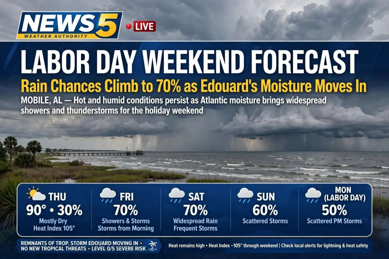
MOBILE, Ala. — Hot and humid conditions will persist through the Labor Day weekend, but an increase in Atlantic moisture will bring a significant uptick in showers and thunderstorms, especially Friday through Sunday.
Thursday: Hot, Mostly Dry
Thursday will remain hot, with highs in the low 90s and a heat index climbing to around 105.
Rain chances stay low at 30%, with only a few spotty showers and storms possible. For anyone with outdoor plans that need a dry window, Thursday is the most reliable day of the stretch.
Friday: The Pattern Change
Friday is when conditions shift. Morning showers and storms are expected near the coast, followed by a good chance of showers and storms in the afternoon as moisture increases.
Rain chances jump to 70%.
A morning-then-afternoon storm sequence like this one is characteristic of a genuinely moist air mass rather than a typical summer sea-breeze day. When storms are already firing near the coast in the morning, it indicates there is enough moisture and instability in place that the atmosphere is not waiting on afternoon heating to produce rain.
Saturday and Sunday
Saturday looks similar to Friday, with elevated moisture hanging over the area and widespread rain chances remaining high. Frequent showers and storms are expected throughout the day.
Sunday sees rain chances stay elevated at 60%.
Labor Day Monday
Rain chances decrease slightly to 50% on Monday for the Labor Day holiday itself.
A 50% chance does not mean half the day will be rainy. It means roughly half the area can expect measurable rain at some point — which, in a scattered-storm pattern, typically translates to brief heavy downpours moving through rather than a day-long washout.
The Heat Continues
Heat will build back in during the second half of the weekend and into next week, with heat index values around 105 each day.
While not extreme by Gulf Coast standards, the combination of heat and humidity will make conditions uncomfortable, particularly for anyone working or exercising outdoors. A heat index near 105 sustained across multiple days carries cumulative risk — the body has less opportunity to recover overnight when humidity keeps low temperatures elevated.
Practical precautions apply: drink water before you feel thirsty, schedule strenuous outdoor activity for early morning, take shade breaks, and watch for the early signs of heat exhaustion — heavy sweating, weakness, nausea and dizziness.
Beach and Safety Considerations
For those heading to the beach, the risk of rip currents is relatively low across the weekend.
That said, the lower rip current risk should not be mistaken for an all-clear. The greater hazard this weekend is lightning. Pop-up thunderstorms can develop quickly, and open beaches offer no shelter and no advance warning beyond what a person notices in the sky.
The standard guidance is worth repeating: when you hear thunder, leave the water and seek substantial shelter — a building or a hard-topped vehicle, not a beach umbrella or a pavilion. Wait 30 minutes after the last rumble before returning.
Beach flag warnings should be checked at the access point before entering the water, since conditions can change during the day.
Where the Moisture Is Coming From
The moisture in the atmosphere is a remnant of Tropical Storm Edouard.
Remnant tropical moisture is a common late-summer feature along the Gulf Coast. Even after a storm loses its circulation and is no longer classified as a tropical system, the deep moisture it carried can drift into the region and raise rain chances for days — producing exactly the pattern forecast for this weekend, with widespread showers and storms rather than isolated afternoon activity.
No New Tropical Threats
The encouraging part of the forecast is what is not in it. No tropical storm formation is expected over the next seven days, meaning no new tropical threats are developing for the region during the holiday period.
For a Gulf Coast Labor Day weekend, that is the more significant headline. A wet, muggy holiday with scattered storms is an inconvenience; an approaching system would be something else entirely.
Planning the Weekend
The practical takeaway: Thursday is the driest day, Friday and Saturday are the wettest, and Sunday and Monday sit in between. Outdoor events across the weekend should build in flexibility and a plan for moving indoors quickly, and anyone spending the day outside should treat heat as the constant and storms as the variable.
Orange Beach Seven-Day Outlook
The City of Orange Beach issued its own weather update for the same period, with a slightly cooler coastal picture than areas inland. The sea breeze keeps the extreme coast in the upper 80s to low 90s, while areas north of Interstate 10 reach the mid to upper 90s in some locations.
Thursday: Scattered showers and thunderstorms possible, otherwise partly cloudy, highs in the upper 80s and overnight lows in the mid 70s. Winds light and variable.
Friday: Increasing cloud cover with a stray shower or thunderstorm possible. Highs near 90, overnight lows in the low to mid 70s. East winds 5 to 10 mph.
Saturday: Scattered showers and thunderstorms, partly to mostly cloudy, highs in the upper 80s and lows in the mid 70s. Southwest winds 5 to 10 mph.
Sunday: Partly cloudy with scattered afternoon showers and thunderstorms. Highs in the upper 80s to low 90s, lows in the low to mid 70s.
Labor Day: A mixture of clouds and sunshine with an increased chance of scattered afternoon thunderstorms. Highs in the upper 80s to low 90s.
Tuesday and Wednesday: Sunny at times with a chance of scattered showers and thunderstorms, highs in the upper 80s and lows in the mid 70s.
Next Thursday: Scattered showers and thunderstorms possible, otherwise partly cloudy with highs in the upper 80s.
Severe Weather and Rainfall Risk
Scattered showers and thunderstorms are expected at times, with a Level 0 of 5 severe weather outlook through the weekend and into next week. Widespread severe weather is not expected, though a few storms could produce damaging winds and frequent lightning.
There is a marginal risk — at least 5% — of excessive rainfall over the next five days.
Beach Conditions and the Tropics
Rip current risk is rated low to moderate through the weekend and early next week. A nearby thunderstorm can change beach conditions quickly, and beachgoers should check Orange Beach Surf Rescue for the latest flag status and surf conditions before heading out.
There are no tropical threats for the next five to seven days across the Atlantic Basin, including the Caribbean and the Gulf. Hurricane season is roughly 50% complete, placing this stretch at the climatological peak.