Mobile, Alabama skylineMobile, Alabama.

Historical report, published from archived local news coverage.

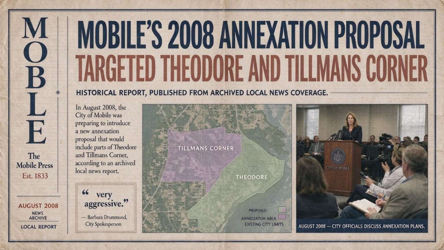
In August 2008, the City of Mobile was preparing to introduce a new annexation proposal that would include parts of Theodore and Tillmans Corner, according to an archived local news report. The plan, described by a city spokesperson as one of the most expansive annexation pushes the city had considered in years, targeted portions of the fast-growing unincorporated communities south of the city limits along the U.S. 90 corridor. For residents of those communities, the proposal raised questions that had surfaced repeatedly in Mobile County for decades: whether joining the city would bring better services and stronger representation, or simply higher taxes and a loss of local identity.

A ‘Very Aggressive’ Pitch

City spokesperson Barbara Drummond told the station that the plan would be “very aggressive.” The characterization signaled that city officials were not proposing a modest, parcel-by-parcel expansion of the kind that had dotted Mobile’s growth map over the years, but a broad attempt to bring large populated sections of southern Mobile County inside the city limits. In an era when Mobile’s population had plateaued while unincorporated areas to the south and west continued to add subdivisions, shopping centers and schools, the stakes of the census were clear to city planners: every new resident annexed was a resident counted toward the city’s next federal census tally.

A map obtained by the station showed the areas the city hoped to add. The mapped zones stretched across portions of Theodore and Tillmans Corner, two of the most densely developed unincorporated communities in the county. Both areas had long been closely tied to Mobile commercially and culturally even while remaining outside the city, a common arrangement across Alabama where urbanized fringe communities often receive some city-like services through county government and special districts without paying municipal taxes or voting in municipal elections.

Recent Precedent in West Mobile

The report noted that Mobile had annexed portions of West Mobile the previous September, including Mobile Terrace, Cadillac Park, parts of the Schillinger Road business corridor and areas along Airport Boulevard. That earlier annexation had followed the same playbook city officials appeared to be applying on the southern edge: identify contiguous, populated, commercially active areas adjacent to the city limits and fold them in, often with the cooperation of property owners who wanted access to city services or zoning protections.

See also  Serda's Coffee Company Opens on Royal Street, Filling a Downtown Mobile Void

The Schillinger Road corridor in particular had become one of the busiest retail and service strips in the western part of the county, and the stretches of Airport Boulevard included in that annexation were part of a thoroughfare that runs from central Mobile westward through some of the metro area’s most developed commercial real estate. Adding those corridors to the city had broadened Mobile’s sales tax base, a consideration that loomed over every annexation debate in the county, since municipal budgets in Alabama depend heavily on local sales tax revenue rather than property tax.

Why Theodore and Tillmans Corner

Theodore and Tillmans Corner sit south of the Mobile city limits, anchored by the U.S. 90 corridor that runs toward the Alabama State Docks to the north and down toward Grand Bay and the Mississippi line to the south. Theodore is home to a major industrial and petrochemical presence along the Mobile Bay shoreline, including large refinery and chemical operations that have anchored the local economy for generations, while Tillmans Corner developed as a dense suburban-commercial hub around the intersection of U.S. 90 and Schillinger Road. Both communities had grown steadily as families priced out of or priced away from older city neighborhoods moved south for newer housing.

Because both communities were unincorporated, their residents relied on the Mobile County Commission and the Mobile County Sheriff’s Office rather than a city government for a range of services, supplemented by volunteer-supported fire departments and special-purpose districts. That arrangement meant lower overall tax bills than city residents typically paid, but it also meant less direct control over zoning, planning and code enforcement. For the City of Mobile, meanwhile, extending services across those areas came with real costs: police beats, fire stations, garbage routes and street maintenance all had to be funded and staffed, and city officials in 2008 were weighing whether the tax base the annexed areas would bring could offset those obligations.

The proposal renewed a local debate over whether annexation would be welcomed or become divisive. Similar efforts in Mobile County over the years had drawn sharply mixed responses from residents. Some property owners in unincorporated areas actively sought annexation, wanting city police and fire protection, city-paved streets and access to municipal amenities. Others opposed it on principle or economics, wary of municipal property taxes, city business licensing and the prospect of seeing longtime volunteer fire departments subsumed into a city department. School attendance lines, which in Mobile County largely follow countywide public school district boundaries rather than municipal ones, were often less of a factor than taxes and services, but neighborhood identity ran deep in communities that had never had their own city hall.

See also  Mobile Bay Ferry Dock on Dauphin Island Set for Upgrade

The Mechanics of Annexation in Alabama

Annexation in Alabama can proceed through several routes, most commonly when a majority of property owners in a contiguous territory petition for it, or when the governing body of the city votes to annex an area with owner consent. Cities sometimes sweeten the prospect by announcing what services and improvements will follow annexation, and opponents frequently push back with petitions of their own. The process almost always becomes a civic argument about identity as much as economics, particularly in areas like Theodore and Tillmans Corner where generations of families had lived without a municipal government and considered the arrangement part of who they were.

What the August 2008 Plan Meant at the Time

As the report circulated in August 2008, the immediate questions were practical. Which streets and subdivisions exactly fell inside the mapped boundaries? Would the city phase in services for newly annexed areas or extend them immediately? And would residents, once presented with the details, sign on or organize against the plan? Local officials and residents alike knew from the West Mobile annexation the previous September that boundaries drawn on a map could look very different once property owners began examining what the change would mean for their tax bills and their neighborhoods.

The timing also intersected with broader trends. Mobile’s population had hovered near its historic highs through the 2000s, and cities across the Gulf Coast were competing to show growth ahead of the 2010 census, which would determine federal funding formulas and statistical rankings for a decade. Communities south of the city had also been rebuilding and growing after Hurricanes Ivan and Katrina, adding another layer to the calculus for city leaders trying to plan for storm recovery, drainage and infrastructure demands across the region.

See also  Mobile County Schools Defends Hiring Process After Background Check Gap Surfaces

The Services Question at Street Level

Beneath the boundary lines, the debate in 2008 turned on day-to-day services that residents could measure. City residents were used to weekly garbage and trash collection run by municipal crews, streetlights maintained by the city, building permits handled at city hall and police response from a municipal department with citywide dispatch. Unincorporated residents, by contrast, paid less and lived with the trade-offs: sheriff’s patrols spread across a huge county, roads maintained by county crews with budgets that never stretched far enough, and planning rules that were generally looser than city zoning. Neither side of the ledger was simply better, which is exactly why annexation fights in the county rarely ended with everyone satisfied.

Business owners along the commercial corridors added another dimension. Retailers and service businesses on Schillinger Road, Airport Boulevard and U.S. 90 had watched earlier annexations change their licensing, signage and tax obligations, and some had found advantages in the change while others bristled at it. Any proposal that swept in long stretches of commercial frontage, as the mapped areas in Theodore and Tillmans Corner did, was certain to draw close attention from that audience long before residents of a single subdivision took a position.

Looking Back From Today

This account reflects the plan and discussion at that time; it does not describe the proposal’s later outcome. Whether the aggressive 2008 annexation push advanced, stalled or was scaled back, the episode remains a window into the recurring tug-of-war between Mobile and the unincorporated communities on its southern and western edges — a contest over taxes, services, representation and identity that has shaped Mobile County’s map for generations. For today’s readers in Theodore, Tillmans Corner and west Mobile, the archived report is a reminder that the boundaries drawn around their neighborhoods were contested, negotiated and revisited repeatedly, and that the question of what belongs inside the city limits has never been settled once and for all.