Limestone Barges Head South to Rebuild the Oyster Reefs of Lower Mobile Bay
Barges loaded with limestone are traveling hundreds of miles down Alabama's rivers to Cedar Point in southern Mobile County, where the rock will be spread across the bay bottom to give young oysters a place to grow.
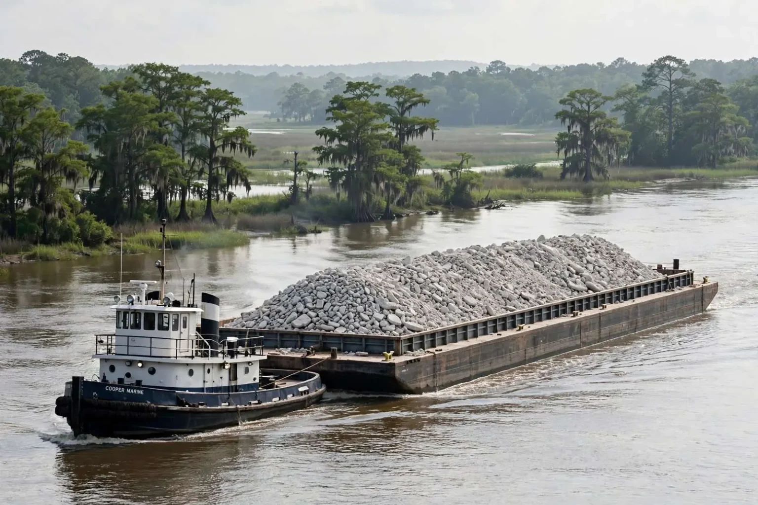
Somewhere on the Tombigbee River this month, a barge is moving slowly south with a load of crushed limestone that began its journey in a quarry in northwest Alabama. Its destination is the bottom of lower Mobile Bay, and its purpose is to give oysters something to hold onto.
The Project
The effort is a major conservation project led by the Alabama Wildlife Federation and its partners, aimed at restoring oyster reefs near Cedar Point in southern Mobile County. The latest shipment of rock began its trip in early July from northwest Alabama and is expected to arrive on the Gulf Coast later this summer. Scientists will continue monitoring the restored reefs for years after the material is placed.
The Alabama Wildlife Federation, founded in 1935, is the state’s oldest and largest citizens’ conservation organization. Its involvement in oyster restoration reflects a decades-long commitment to the health of Alabama’s coastal ecosystems. The federation works alongside the Alabama Department of Conservation and Natural Resources, the National Fish and Wildlife Foundation, and numerous local partners to identify priority sites where cultch placement will yield the greatest ecological return.
The rock is known as oyster cultch, and it addresses the single most basic problem facing oyster recovery in Mobile Bay. Oyster larvae, once they are ready to settle out of the water column, need a hard surface to attach to. Without one, they land in soft mud and die. No amount of clean water or favorable salinity will produce an oyster reef if there is nothing solid on the bottom for the first generation to cement itself to. Limestone has become a preferred material because it provides a durable foundation that will not wash away or dissolve in a season.
Cultch deployment is a well-established restoration technique along the Gulf Coast. The limestone pieces — typically two to four inches in diameter — create a complex, three-dimensional matrix with abundant interstitial spaces. This structure not only receives settling larvae but also shelters juvenile oysters from predators such as oyster drills and blue crabs during their most vulnerable months. Research from the Dauphin Island Sea Lab and the University of South Alabama has shown that properly distributed cultch can accelerate reef development by years compared to waiting for natural shell accumulation.
A Long Trip
The logistics are worth appreciating. The limestone comes from a quarry in Tuscumbia, in the far northwest corner of the state. Once loaded onto barges, it travels hundreds of miles along the Tennessee and Tombigbee rivers before reaching Mobile Bay. Residents along the waterways have watched the barges make their slow way south.
This journey is made possible by the Tennessee-Tombigbee Waterway, a 234-mile navigation channel completed by the U.S. Army Corps of Engineers in 1985. The waterway connects the Tennessee River to the Tombigbee River, creating a commercial shipping route from the nation’s midsection to the Gulf of Mexico. For this project, it means limestone quarried in the Appalachian foothills can reach Mobile Bay at a fraction of the cost of overland truck transport. Each barge tow can carry the equivalent of dozens of tractor-trailer loads, reducing both expense and highway wear.
Once the rock arrives at the restoration site, crews use high-pressure water cannons to blast it off the barge and spread it across the bay bottom. The technique distributes the material evenly across the target area rather than dumping it in a pile, creating the broad, textured surface that oyster larvae need.
Why Mobile Bay Lost Its Reefs
Mobile Bay has lost much of its historic oyster habitat, and no single cause explains it. The decline is the cumulative result of:
- Overharvesting over generations, which removed not only the oysters but the shell substrate that future oysters would have settled on.
- Storms, which bury reefs under sediment or scatter them outright.
- Shifting environmental conditions, including changes in salinity driven by freshwater inflow.
- Sediment buildup, which smothers the hard bottom that reefs require.
The loss compounds itself. Each reef that disappears takes with it the substrate that would have seeded the next one.
Historical records indicate that Mobile Bay once supported one of the most productive oyster fisheries in the United States. In the late nineteenth and early twentieth centuries, the bay’s public reefs yielded millions of pounds of oyster meat annually, supporting a thriving canning industry and employing thousands of coastal residents. The collapse of this fishery was not sudden but incremental — each drought that lowered salinity, each hurricane that buried reefs, each season of heavy tonging that removed more shell than was replaced, chipped away at the system’s capacity to recover. By the early 2000s, many of the bay’s historically productive public reefs had fallen below the threshold density needed for successful natural recruitment.
What Oysters Do for a Bay
Restoring reefs is not only about restoring oysters. A functioning reef is a piece of working infrastructure.
- Water filtration. Oysters feed by filtering water, removing algae and suspended particles. A healthy reef processes an enormous volume of water, improving clarity and quality.
- Habitat. Reefs provide structure for fish, crabs, shrimp, and countless other marine species. Structure on an otherwise featureless bottom is where life concentrates.
- Shoreline protection. Reefs absorb wave energy, reducing erosion during storms and high tides. In a region that measures its vulnerability in feet of shoreline, that is a tangible benefit.
- Fisheries. Better water quality and more habitat support both the commercial and recreational fisheries that have sustained coastal Mobile County communities for generations.
The filtration capacity of a mature oyster reef is staggering. A single adult oyster can filter up to fifty gallons of water per day under optimal conditions. At historical population densities, the reefs of lower Mobile Bay would have turned over the bay’s entire water volume every few days, a natural treatment system that kept algae blooms in check and maintained the light penetration needed for submerged aquatic vegetation. The loss of that filtration capacity has been linked to increased turbidity and periodic hypoxic events in the bay’s deeper channels.
For recreational anglers, the restored reefs at Cedar Point will mean more reliable structure holding speckled trout, redfish, flounder, and sheepshead. For commercial shrimpers and crabbers, healthier nursery habitat translates to stronger year-classes. The Alabama Marine Resources Division monitors these populations through its fishery-independent survey programs, providing the data that will ultimately measure the project’s success.
The Partnership Behind It
The Alabama Wildlife Federation is leading the restoration, supported by public and private partners. Vulcan Materials supplies the limestone, and Cooper Marine transports the rock by barge. Those partnerships are what make the economics work. Buying and shipping thousands of tons of rock hundreds of miles at commercial rates would put a project of this scale out of reach for most conservation budgets.
Vulcan Materials, the nation’s largest producer of construction aggregates, has a longstanding presence in Alabama with quarries and distribution facilities across the state. Their donation of limestone for conservation projects reflects a broader corporate commitment to the communities where they operate. Cooper Marine, headquartered in Mobile, operates one of the largest inland marine transportation fleets on the Gulf Coast. Their expertise in moving heavy bulk commodities on the river system is essential to making large-scale cultch deployment feasible.
Public funding for the project comes from multiple sources, including the National Fish and Wildlife Foundation’s Gulf Environmental Benefit Fund — established with funds from the Deepwater Horizon oil spill settlement — and the Alabama Department of Conservation and Natural Resources’ State Wildlife Grants program. This blend of settlement dollars, state appropriations, and private in-kind contributions is the model that has sustained Alabama’s oyster restoration program through multiple administrations and economic cycles.
Where Cedar Point Sits
The Cedar Point restoration area lies on the western side of lower Mobile Bay, near the mouth where the bay opens into the Gulf. It is water that the seafood communities of southern Mobile County know as well as their own streets, and it has historically been productive oyster ground.
Cedar Point’s location at the bay’s interface with the Gulf gives it a salinity regime that, in most years, falls within the optimal range for eastern oyster growth and reproduction — typically fifteen to twenty-five parts per thousand. This salinity window is wide enough to support robust oyster populations but high enough to suppress the oyster drill, a predatory snail that devastates reefs in higher-salinity waters. The site’s proximity to the Gulf also means it receives regular larval supply from offshore spawning populations, a critical factor for reefs that are too far upstream to benefit from Gulf-derived recruitment.
Monitoring and the Long View
If the new reefs develop as expected, they will improve water quality, create valuable wildlife habitat, and strengthen one of Alabama’s most important coastal ecosystems. Scientists will be measuring oyster growth and the return of marine life over the coming years to determine whether the rock did its job.
Monitoring protocols established by the Alabama Marine Resources Division and academic partners include quarterly assessments of spat set (the density of newly settled oysters), annual measurements of oyster density and size distribution, and ongoing water quality sampling at fixed stations around the restoration footprint. These data feed into adaptive management decisions — if spat set is low in a given year, managers may supplement with hatchery-reared spat; if predation is high, they may adjust cultch density or timing in subsequent deployments.
The project also exists within a broader Gulf-wide context. Louisiana, Mississippi, and Texas all operate large-scale cultch programs funded through similar combinations of spill settlement dollars, state appropriations, and federal grants. The Gulf States Marine Fisheries Commission coordinates data sharing across state lines, allowing managers to compare techniques and outcomes across the region. What works at Cedar Point may inform projects in Heron Bay, Mississippi, or Calcasieu Lake, Louisiana, and vice versa.
It is a long-term investment, in every sense. The barges take a season to arrive, the oysters take years to establish, and the payoff arrives quietly, in cleaner water and fuller nets.