Mobile Launches Citywide Stormwater Survey to Map Drainage and Fight Flooding
Mobile is surveying about 36,000 stormwater features citywide using RESTORE Act funds, building data officials say will guide flood mitigation.
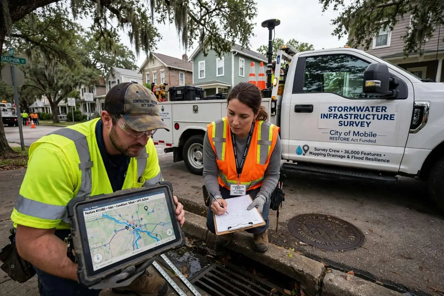
The City of Mobile has hired contractors to carry out a comprehensive survey of its stormwater infrastructure, a project funded through the RESTORE Act. Over the coming months, crews working with the city will analyze roughly 36,000 stormwater features across every neighborhood in Mobile, according to a city spokesperson.
The scale of the effort is hard to overstate. Thirty-six thousand features — inlets, pipes, outfalls, ditches and the other components that make up a drainage network — amount to one of the most detailed examinations of Mobile’s below-ground and roadside water system ever undertaken, and the work will reach every part of the city rather than focusing only on known trouble spots.
Officials say the study is designed to give the city a clearer picture of how water moves through the city during storms — where it drains well, where it backs up, and which parts of the network are aging or undersized. That information is expected to guide future flood mitigation efforts and help protect Mobile’s waterways from polluted runoff.
The RESTORE Act funding gives the project its footing. The federal law directs penalties from the Deepwater Horizon disaster back to the Gulf Coast states for restoration and resilience work, and Mobile’s decision to spend a share of those dollars on understanding its own drainage system reflects a judgment that mapping the problem is the necessary first step to fixing it.
Why the survey matters
Flooding is a recurring challenge across the Gulf Coast, and Mobile’s drainage system handles runoff from heavy rain events that can overwhelm streets and neighborhoods. Residents are familiar with the pattern: an afternoon downpour turns underpasses into ponds and low-lying streets into shallow rivers, and the system’s ability to keep up determines how quickly the city dries out.
By cataloging tens of thousands of individual features — inlets, pipes, outfalls, ditches and other components — the city aims to build a detailed map of what it owns and how it performs. Many cities have grown faster than their asset records, and crews in the field often discover infrastructure that exists on no current map, along with structures that have silted up, collapsed or quietly stopped serving their purpose.
Field crews will document each feature’s location, size, condition and connectivity, creating the kind of engineering-grade inventory that modern stormwater management requires. The survey data will feed computer models of how the network behaves in storms of various sizes, letting engineers test scenarios before spending construction dollars.
The data gathered will serve as a foundation for planning repairs, prioritizing upgrades and applying for additional funding for flood control projects. Grant applications, in particular, depend on defensible data — a documented inventory of need carries far more weight with state and federal funders than anecdote, and Mobile’s survey is designed to produce exactly that.
For residents, the survey will be visible before it is useful. Crews working in neighborhoods will lift manhole covers, measure pipes, photograph inlets and work from trucks marked with contractor identification, and city officials have encouraged residents to expect the activity in their streets over the months of fieldwork and to grant crews room to work safely where the survey takes them near driveways and ditches.
The neighborhood-by-neighborhood approach also means the survey’s eventual findings will touch every district. Areas that flood routinely will find their problems documented and quantified; areas where the system works quietly well will find that confirmed too, which matters when budget debates arrive and every part of the city is competing for drainage dollars.
Transparency has been part of the city’s pitch, with the spokesperson’s account of the project’s scope standing as the public’s clearest picture of what the crews are doing and why it matters to every address in town.
Mobile’s hydrology makes the stakes concrete. The city sits where the Mobile River meets Mobile Bay, ringed by creeks, bayous and low ground, and much of its street grid was laid out across terrain that historically held water. Development added impervious surface faster than the drainage network grew, and aging pipe installed generations ago continues to age no matter what the rainfall does.
Climate patterns sharpen the concern. Heavy rain events across the Gulf Coast have grown more intense, stressing drainage systems designed decades ago for milder storms. A city that understands exactly what it has — and what condition it is in — can plan capacity improvements where they will do the most good.
From survey to strategy
City officials have framed the effort as an investment in long-term resilience for a city whose history and geography are inseparable from water. Mobile grew up around the port and the rivers that sustain it, and its future — economic and physical — depends on managing the relationship between its streets and its waterways.
The survey’s findings will feed a pipeline of decisions. Repairs can be scheduled where collapsed or blocked structures threaten immediate flooding; upgrades can be prioritized where undersized pipes repeatedly fail; and new development can be reviewed against a known picture of the network’s capacity rather than guesswork.
The water quality dividend is equally important. Runoff that moves efficiently through the network carries oil, sediment, fertilizer and litter toward the bay, and a mapped, functioning system gives the city the ability to place pollution controls — catch basin inserts, detention features, outfall treatments — where they will intercept the most contaminated flow.
Regional partners are watching the work as well. Mobile County’s municipalities share watersheds with the city, and a detailed map of the system inside the city limits helps coordinate the drainage decisions that do not respect boundary lines.
For now, the project’s promise is measurement. Thirty-six thousand features examined one by one will not dry a single street by themselves, but they will give Mobile the first complete picture of the system it depends on every time the rain comes — and every project that follows, from a repaired outfall to a grant-funded retention basin, will stand on that foundation.
The RESTORE Act context places Mobile’s project within a Gulf-wide rethinking of water infrastructure. The 2012 law dedicated the Clean Water Act civil penalties from the Deepwater Horizon spill to recovery programs across the affected states, and Alabama’s allocation has funded everything from coastal habitat projects to infrastructure planning. Stormwater mapping falls squarely within the act’s resilience purpose: preventing the kind of chronic flooding that erodes neighborhoods and economies.
Contractors specializing in this work bring equipment that older surveys never had. Global positioning systems record each feature’s location precisely, closed-circuit cameras inspect pipe interiors, and the resulting database integrates with the city’s geographic information systems so that planners can call up any structure’s condition on a map instantly.
The fieldwork’s pace will be dictated by the sheer number of sites. Thirty-six thousand features at even a brisk daily clip represents months of crews in the field, moving neighborhood to neighborhood, and residents will likely see the trucks repeatedly as different phases of the work pass through.
Data collection is only as valuable as its maintenance, and city staff have indicated the survey is intended to seed a living database rather than a one-time report. A network inventory that is updated as repairs and new construction occur remains useful for decades; a snapshot goes stale quickly.
Flooding as Mobile’s recurring test
Anyone who has driven Mobile during a summer downpour knows the system’s character. Streets that drain within minutes sit alongside stretches that pool for hours, and the difference often traces to features the survey will now document — an undersized pipe upstream, an inlet buried under silt, a ditch redirected by decades of growth.
City departments have responded to flooding complaints for years with the tools available, but reactive maintenance without a systemwide picture risks spending on visible symptoms while deeper problems persist. The survey converts that reactive posture into a planning posture: every crew visit will add data, and every dollar of repair can be weighed against the network’s full map.
The insurance and economic angles are significant too. Flood losses raise costs for homeowners and businesses, depress property values in repeatedly inundated areas and strain city budgets through emergency response and infrastructure repair. Resilience investments like this survey are the quieter work that reduces those losses over time.
Mobile’s waterways benefit alongside its streets. Three Mile Creek, Dog River, Eslava Creek and the other streams that thread the city carry the runoff the network collects, and a drainage system performing as designed — with pollution controls and maintained outfalls — delivers cleaner water to the bay than a clogged and crumbling one.
The survey is the beginning of that chain, and the city’s messaging has stressed the same conclusion at every step: before Mobile can fix its stormwater system, it has to know exactly what it has. The months of fieldwork ahead will build that knowledge feature by feature, one inlet at a time.