The Raphael Semmes Bridge: One Man’s Downriver Answer to Mobile’s I-10 Fight
A 77-year-old retired federal contracting officer who once taught Jimmy Buffett to sail proposed a straight east-west I-10 crossing over Pinto Island, 360 feet above the river, that he said would satisfy every warring interest.
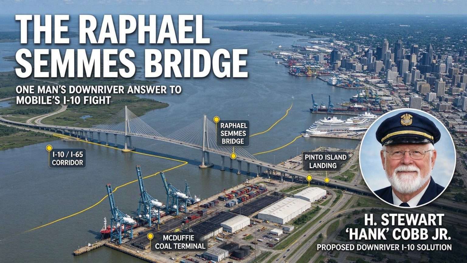
On first encountering H. Stewart “Hank” Cobb Jr., a short, round 77-year-old, one would not necessarily guess he had taught Jimmy Buffett to sail, or that he believed he had solved the fight consuming Mobile over where to put a new Interstate 10 bridge across the Mobile River. He had done the first. He was convinced he had done the second. “I taught Jimmy Buffett to sail when I was a Sea Scout Skipper,” Cobb recalled. An Eagle Scout with 52 years as a Scouter and 42,000 miles of ocean racing behind him, Cobb spent a 25-year career as a federal contracting officer analyzing 20 to 40 multimillion-dollar contractor proposals a year. He liked problems. He liked them best when the experts had gotten stuck.
The Fight He Wanted to End
The proposed I-10 bridge was meant to relieve the bottleneck strangling a cross-country artery at the Wallace Tunnel. But every route on the table had enemies. Shipyards and waterfront interests warned a bridge would foul the lifeblood of the local economy. The new cruise terminal, home to Carnival’s Holiday, feared a mammoth bridge footing would squash Mobile’s future as a cruise port. Historic preservationists, downtown redevelopment advocates and Down the Bay residents all recoiled from a 200-foot-plus structure looming over them. Of an original 14 alternate routes, engineers had narrowed the field to three, all crossing mid-river. A northern option using the Cochrane-Africatown Bridge had reportedly been vetoed by federal highway officials.
The Wallace Tunnel, opened in 1973, carries I-10 beneath the Mobile River at a choke point where four lanes narrow to two in each direction. During peak hours, holiday weekends, and any incident that closes a lane, traffic backs up for miles on the Bayway and across the causeway. The Alabama Department of Transportation (ALDOT) had studied bridge alternatives for decades, with each proposal generating fierce opposition from one constituency or another. The tunnel itself cannot be easily expanded — its immersed-tube construction and the river traffic above make widening prohibitively expensive and environmentally fraught.
Hidden in Plain Sight
“Where is this mysterious, elegant and simple location?” Cobb asked. “The answer is that it is hidden, hidden in plain sight!” His route: from the I-65 merge with I-10, run straight east to the Broad Street overpass, rise on a straight approach ramp up and over the McDuffie Coal Terminal, cross the bridge at the tip edge of the mouth of the Mobile River, come down over Pinto Island south of the Battleship Alabama, and merge into a new Bayway in the center of the bay.
Cobb’s proposal, which he called the Raphael Semmes Bridge after the Confederate naval captain whose statue stands near the waterfront, aimed to thread the needle between competing interests. By crossing at the river’s mouth rather than mid-river, the bridge would avoid the shipyard channel, the cruise terminal turning basin, and the historic downtown viewshed. The approach over the McDuffie Coal Terminal — an industrial facility already elevated on pilings — minimized displacement of residential neighborhoods. The landing on Pinto Island, home to the Alabama State Docks’ container operations and the Battleship Memorial Park, utilized already-industrialized waterfront.
A Career Built on Analysis
Cobb’s confidence came from a career spent evaluating complex proposals for the federal government. As a contracting officer, he had seen countless projects founder on poor planning, political interference, and failure to anticipate second-order consequences. He applied the same analytical framework to the bridge problem: define the requirements, evaluate alternatives against objective criteria, and select the option that maximizes benefit while minimizing harm. His criteria included navigation clearance for the Port of Mobile, visual impact on historic districts, displacement of residents and businesses, construction cost, and long-term maintenance burden.
What distinguished Cobb’s analysis was his willingness to question the premise that the bridge must cross at the narrowest point of the river. The three official alternatives all clustered around the same mid-river crossing because conventional engineering wisdom favors the shortest span. But Cobb argued that the shortest span created the most conflicts — precisely where the shipyards, cruise terminal, and historic districts converge. A longer span at the river’s mouth, while more expensive in steel and concrete, avoided billions in mitigation costs and decades of litigation.
The Maritime Perspective
Cobb’s sailing background gave him a perspective few transportation planners possessed. He understood the Mobile River not as a line on a map but as a dynamic waterway shaped by tides, currents, and the vessels that transit it. The Port of Mobile handles roughly 27 million tons of cargo annually, ranking among the top 15 U.S. ports by tonnage. Its turning basins, anchorages, and approach channels require clear airspace and water columns that a mid-river bridge with 215-foot vertical clearance — the standard for the official alternatives — would constrain during high-water events and for the largest vessels calling on the port’s expanding container terminal.
Cobb’s river-mouth crossing would provide effectively unlimited vertical clearance for the main shipping channel, as the bridge would land downstream of the primary navigation corridor. The tradeoff was a longer main span — approximately 8,000 feet versus 3,500 feet for the mid-river options — but modern cable-stayed and suspension bridge technology routinely achieves such spans. The Sunshine Skyway Bridge across Tampa Bay spans 29,000 feet with a main span of 1,200 feet. The Arthur Ravenel Jr. Bridge in Charleston spans 13,200 feet with a 1,546-foot main span. Both carry interstate traffic over active shipping channels with clearance exceeding 185 feet.
Political and Institutional Resistance
Despite the technical merits, Cobb’s proposal faced institutional inertia. ALDOT had invested years and millions of dollars in the environmental review process for the three official alternatives. The Federal Highway Administration, which must approve any interstate bridge project, typically defers to the state DOT’s preferred alternative absent compelling evidence of fatal flaws. Local elected officials, mindful of constituent opposition in their districts, tended to support the alternative that minimized visible impacts in their specific areas rather than the one that optimized regionally.
The cruise terminal issue illustrated the political dynamic. Carnival Cruise Line had committed to homeporting the Holiday in Mobile, a coup for a city that had never hosted a year-round cruise ship. The terminal, built with $27 million in state and local funds, sat directly in the path of two of the three official bridge alternatives. The third alternative required a massive footing that terminal advocates argued would disrupt the turning basin. Cobb’s route bypassed the terminal entirely, but by the time he publicized it, the cruise terminal had become a political sacred cow — no elected official wanted to be seen as threatening Mobile’s newest tourism asset.
The Environmental Review Process
The National Environmental Policy Act (NEPA) process governing major transportation projects requires evaluation of alternatives, public comment periods, and mitigation planning for unavoidable impacts. For the Mobile River Bridge, the Draft Environmental Impact Statement (DEIS) evaluated the three mid-river alternatives across categories including air quality, noise, wetlands, historic properties, environmental justice communities, and navigation. The process, which began in earnest in the early 2000s, had already consumed over a decade and tens of millions in consulting fees by the time Cobb went public with his alternative.
Introducing a new alternative at that stage would technically require supplementing the DEIS — a step that could add years to the timeline. ALDOT and FHWA officials were understandably reluctant to reopen a process that had already survived multiple legal challenges from environmental groups and historic preservation organizations. Cobb countered that the existing alternatives were fundamentally flawed and that proceeding with any of them would guarantee litigation from the constituencies they harmed, ultimately delaying the project further.
Legacy and Lessons
Hank Cobb died in 2015 at age 85, never seeing his bridge built. The Mobile River Bridge project continued to evolve — a public-private partnership model was proposed, then shelved; a toll-based financing plan sparked political backlash; the project was revived under the I-10 Mobile River Bridge and Bayway Program with a revised alternative that incorporated some elements of a downstream crossing. As of 2024, the project remains in the planning and permitting phase, with construction not expected to begin before the late 2020s.
Cobb’s story illustrates the tension between technical optimization and political feasibility in major infrastructure. His outsider analysis, grounded in maritime experience and federal contracting rigor, identified a solution that the official process missed — or dismissed — because it didn’t fit the established framework. The Raphael Semmes Bridge remains a what-if in Mobile’s transportation history, a reminder that sometimes the most elegant engineering solution is the one that asks a different question.
The I-10 corridor through Mobile remains one of the most congested freight bottlenecks in the Southeast. The Wallace Tunnel handles roughly 75,000 vehicles per day, well above its design capacity. Truck traffic, commuter flows, and seasonal tourism converge on a crossing that has no redundancy — a single incident can paralyze the Gulf Coast’s primary east-west artery for hours. Whatever bridge eventually rises across the Mobile River will carry not just traffic, but the accumulated weight of decades of debate, deferred decisions, and the ghost of an old sailor who believed he saw the answer hidden in plain sight.
Economic Stakes for the Gulf Coast
The bridge decision carries implications far beyond Mobile’s city limits. The Port of Mobile serves as the primary gateway for containerized cargo moving to and from the Midwest via the CSX and Norfolk Southern rail connections at the port’s on-dock intermodal facility. Delays at the Wallace Tunnel cascade into supply chain disruptions for manufacturers in Alabama, Mississippi, Tennessee, and beyond. The Alabama State Port Authority has invested over $300 million in container terminal expansions since 2015, betting on growth in Gulf Coast trade lanes that a modern bridge crossing would facilitate.
Tourism economics also hinge on the crossing. The Gulf Shores and Orange Beach area, Alabama’s top tourist destination, draws millions of visitors annually who arrive primarily via I-10. Weekend congestion at the tunnel discourages day trips from the Florida Panhandle and western Alabama, costing the coastal economy an estimated $50-80 million in lost visitor spending per year according to tourism industry analyses. A new bridge with adequate capacity would unlock latent demand from markets currently deterred by the unpredictability of the crossing.