Severe risk today as a complex of storms barrel in this afternoon
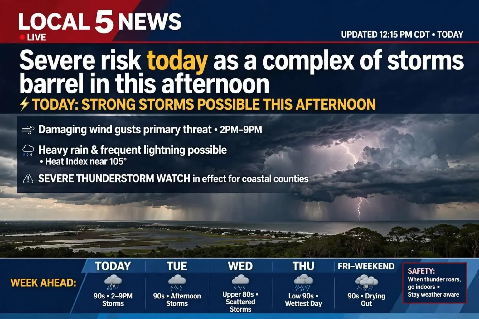
TODAY: STRONG STORMS POSSIBLE THIS AFTERNOON
Scattered to numerous showers and thunderstorms will develop mainly after 1 p.m., with the greatest storm activity expected between 2 p.m. and 9 p.m. Some storms could become strong with damaging wind gusts being the primary concern. Heavy rain and frequent lightning will also be possible in the strongest storms. Highs will reach the low to mid-90s with heat index values climbing around 105 degrees.
Showers and thunderstorms will continue mainly before 7 p.m., then gradually taper off. Heavy rain from any remaining storms could still occur. Lows will drop to the low 70s. Winds will be light from the west becoming calm.
TUESDAY: ANOTHER ROUND OF AFTERNOON STORMS
We’ll see scattered to numerous showers and thunderstorms develop again, mainly after 1 p.m. A few storms could become strong with gusty winds, heavy rain, and frequent lightning. Highs will reach the low to mid-90s with heat index values remaining above 100 degrees. Rainfall amounts could vary considerably from one neighborhood to the next.
WEDNESDAY & THURSDAY: ACTIVE WEATHER CONTINUES
The active pattern continues with scattered to numerous showers and thunderstorms expected each afternoon. Wednesday will see storms mainly after 1 p.m., while Thursday looks to be one of the wettest days of the week with increased rain coverage. Gusty winds, heavy rain, and frequent lightning remain possible in stronger storms. Highs will be in the upper 80s to low 90s, providing some relief from the recent extreme heat.
FRIDAY & WEEKEND: SCATTERED STORMS, THEN DRYING OUT
Scattered showers and thunderstorms will remain possible Friday, mainly after 1 p.m. The weekend looks drier with scattered storm chances Saturday and Sunday, but coverage will be much lower. Highs will be in the low to mid-90s both days.
TROPICS: NO GULF COAST CONCERNS
The National Hurricane Center is monitoring a tropical wave emerging from Africa and an area of low pressure east of Bermuda. Both systems have a medium chance of development over the next week. However, if either system develops, models indicate both would recurve into the open Atlantic well away from the U.S. No tropical impacts are expected along the Gulf Coast over the next 7-10 days. The Gulf and Caribbean remain quiet with no tropical development expected.
UNDERSTANDING THE SEVERE WEATHER THREAT
The setup driving this week’s storms is a familiar one for the central Gulf Coast in late summer. A moist, unstable airmass has settled over south Alabama and the Florida Panhandle, fed by warm water temperatures in the Gulf of Mexico and plenty of low-level moisture streaming northward. When daytime heating combines with that instability, towering cumulonimbus clouds can quickly organize into strong thunderstorms during the afternoon and early evening hours.
The primary hazard in these types of systems is damaging straight-line wind. As rain-cooled air rushes down from a storm’s core, it can spread out at the surface and produce gusts capable of downing tree limbs and power lines. While tornadoes are less common in this particular pattern, they cannot be ruled out entirely when storms interact with any subtle boundaries or sea-breeze collisions near the coast.
Heavy rainfall is the other main concern. With tropical moisture in place, even a slow-moving cell can drop one to two inches of rain in a short time, raising the risk of localized street flooding in low-lying areas and poor drainage spots. Drivers should never attempt to cross a flooded roadway, as the depth of water and the condition of the road beneath it are impossible to judge from a vehicle.
LIGHTNING AND HEAT SAFETY
Frequent lightning accompanies the strongest storms, and it poses a serious threat to anyone caught outdoors. The safest place to be during a thunderstorm is inside a sturdy building or a hard-topped vehicle. The National Weather Service motto is simple: when thunder roars, go indoors. Lightning can strike as far as 10 miles from the center of a storm, so waiting until 30 minutes after the last clap of thunder is the recommended all-clear.
Beyond the storms, the heat is a hazard in its own right. With highs in the low to mid-90s and heat index values near or above 105 degrees, extended time outside can lead to heat exhaustion or heat stroke. Residents are urged to stay hydrated, take frequent breaks in the shade or air conditioning, and check on elderly neighbors and pets during the hottest part of the day.
STAYING INFORMED
The National Weather Service office in Mobile issues watches, warnings, and advisories for the region and provides continually updated forecasts. A Severe Thunderstorm Watch means conditions are favorable for strong storms to develop, while a Severe Thunderstorm Warning means a storm capable of producing damaging winds or large hail is occurring or imminent in the warned area. When a warning is issued for your location, move to an interior room on the lowest floor of a sturdy building and stay away from windows.
Residents can also receive alerts through NOAA Weather Radio, smartphone emergency notifications, and local broadcast and online media. Having multiple ways to receive warnings is especially important overnight, when many people are asleep and unaware of approaching storms.
WHAT TO EXPECT THROUGH THE WEEK
The repeated rounds of afternoon storms mean the ground will have little time to dry out between systems, which can compound any flooding issues by midweek. Thursday, in particular, stands out as the wettest day in the current outlook. By Friday and the weekend, a slight drying trend should lower coverage, though a stray storm cannot be ruled out, especially nearer the coast where sea-breeze activity often fires up during the heat of the day.
Looking further ahead, the absence of any tropical threat in the Gulf is welcome news for coastal communities still well within the heart of hurricane season. Forecasters will keep a close eye on the systems churning in the Atlantic, but current modeling keeps them away from the northern Gulf Coast.
As always, residents are encouraged to keep a weather eye to the sky during the afternoon hours this week, have a plan for where to take shelter, and exercise caution on the roads when storms move through.