Why the Gulf Coast’s Most Dangerous Hurricanes Tend to Arrive After Peak Summer Heat
Ocean heat and lighter wind shear make mid-August through mid-October the most dangerous stretch of hurricane season, as forecasters track a developing Atlantic tropical wave.
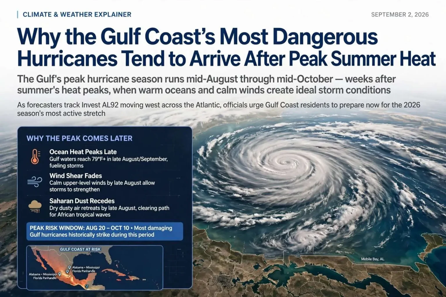
While the Atlantic hurricane season officially begins June 1, the most active and destructive stretch for tropical cyclones actually falls later in the season, spanning from mid-August through mid-October. The calendar’s official start and the atmosphere’s real peak are separated by nearly three months, a gap that matters enormously for Gulf Coast residents who plan their preparedness around the dates. History shows the season’s cruelest weeks arrive precisely when many households have stopped watching the tropics.
Although summer heat peaks in July and early August, the oceanic and atmospheric ingredients needed for major hurricanes don’t fully align until late summer and early fall. The primary driver behind the delay is the thermal mass of the ocean. Water retains heat far longer than air, requiring months of continuous summer sun to warm deep tropical waters to the roughly 79-degree Fahrenheit threshold needed to fuel intense storms. Sea surface temperatures typically reach their maximum in late August and September, right as the season is ramping up toward its peak.
That 79-degree mark is not an arbitrary line. Below it, tropical systems struggle to maintain the deep columns of warm, humid air that hurricanes require; above it, crossing waves can intensify quickly, especially when the water is warm well below the surface. The Gulf of Mexico’s bathymetry adds to the danger in the region’s home waters — the Gulf’s warm waters extend deep, meaning a passing storm stirs up less cool water to slow itself down than it would in other basins.
When the Winds Go Quiet
Atmospheric conditions also become more favorable during this stretch. Vertical wind shear — the change in wind speed and direction with altitude that can tear apart developing storms — is traditionally strong in May and June but fades to a minimum by late August. When that lighter wind shear combines with peak ocean temperatures, high atmospheric moisture and a cooling upper atmosphere that creates greater instability, tropical waves moving off the coast of Africa can organize and intensify rapidly into major hurricanes.
The dry, storm-suppressing Saharan air layer that blows across the Atlantic each early summer also typically fades by late August, clearing the way for storm development. The Saharan Air Layer — dust-laden air that surges off West Africa in pulses — acts as a barrier during June and July, drying out the mid-level atmosphere and choking off the convection developing storms need. When it retreats, the main development region between Africa and the Lesser Antilles opens for business, and the parade of tropical waves that marches westward every three or four days begins finding fuel instead of frustration.
The combination explains the classic shapes of the season’s climatology. Early season storms tend to form close to home — in the Gulf of Mexico, the western Caribbean and the Bahamas — while the August-to-October core brings the long-track Cape Verde hurricanes that cross the entire Atlantic, gathering strength over thousands of miles of warm water. For the Gulf Coast, both varieties matter: homegrown Gulf storms give less warning, while the Cape Verde systems arrive with days of track forecasts but often at full strength.
The 2026 Season’s Active Stretch
As the 2026 hurricane season moves through this pivotal stretch, forecasters continue to track developing systems. The National Hurricane Center has been closely monitoring a tropical wave in the central Atlantic designated Invest AL92, which had become notably better organized, with showers and thunderstorms showing signs of development. Forecasters assigned the disturbance a high probability — 80% — of forming into a tropical depression within 48 hours as it moved westward across the open Atlantic.
An “invest” designation is the National Hurricane Center’s way of flagging a disturbance for concentrated scrutiny — aircraft reconnaissance, specialized computer model runs and enhanced satellite analysis are all dedicated to the system while it remains a candidate for development. The AL and a number identify the storm’s basin and sequence; the label itself carries no indication of strength or threat, only that forecasters are investing resources in watching it. What matters for coastal residents is the development probability and, once a depression forms, the track forecast that follows.
A wave moving westward across the central Atlantic at this point in the season follows the classic late-summer track. Steered by the ridge of high pressure that typically parks over the western Atlantic in August and September, such systems travel west or west-northwest toward the Leeward Islands, the Greater Antilles and eventually the Gulf of Mexico or the southeastern U.S. coast — the waters that include Alabama’s coastline. Whether any given wave strengthens into a hurricane depends on the same ingredients climatologists watch: water temperature, shear, moisture and the upper-air pattern.
What the Peak Means for the Gulf Coast
For Alabama, Mississippi and the Florida Panhandle, the August-to-October peak is written into the region’s hurricane history. Some of the storms that defined the modern Gulf Coast — hurricanes that struck the northern Gulf in September — arrived during exactly this window, when Gulf waters are at their warmest and steering patterns direct tropical systems toward the central Gulf Coast. Mobile Bay’s funnel shape, the low-lying topography of its shoreline and the storm surge history of the region all compound the stakes when a system enters the Gulf during peak season.
Local emergency managers treat mid-August as a checkpoint. Residents are urged to confirm their plans now rather than later: know whether your home is in an evacuation zone, decide on a destination, check insurance documents, gather supplies before the shelves empty, and sign up for local alert systems. The logic is simple arithmetic — once a storm enters the Gulf and becomes a household name, the time remaining to prepare, evacuate or protect property is measured in hours, not weeks.
The late-season peak also carries a psychological hazard that forecasters routinely warn against: fatigue. By late September, a coast that has dodged several near-misses tends to relax, even though October storms have repeatedly struck the Gulf Coast when residents least expected them. The season officially runs through November 30, and some of the region’s most damaging late-season systems have formed from October fronts and Caribbean disturbances rather than Atlantic waves.
Reading the Forecast Signals
Forecasters watch several signals through the peak to judge how threatening the stretch will be. Sea surface temperature anomalies show whether the Atlantic and Gulf are running warmer or cooler than normal; the strength and position of the Bermuda-Azores high shapes where storms travel; and Saharan dust outbreaks indicate when the African wave highway will be suppressed. Seasonal outlooks from NOAA and university forecast groups synthesize those ingredients in advance, but the day-to-day products from the National Hurricane Center — Tropical Weather Outlooks issued four times daily through the peak — remain the definitive source for what is actually forming.
For the central Gulf Coast, the practical guidance rarely changes from year to year: prepare as if a storm will come, watch the tropics daily from August through October, and take every named system in the Gulf or Caribbean seriously regardless of how the season began. The 2026 season is now inside its most dangerous weeks, and the atmosphere’s ingredients — warm water, quiet winds, moisture and waves off Africa — are assembled exactly as climatology says they should be.
Storm naming offers another window into the season’s shape. The alphabet of named storms advances slowly in June and July, then accelerates sharply through the peak — by the time the calendar reaches the letter of mid-September in a typical year, the season has produced most of its hurricanes and a substantial share of its major ones. Emergency managers along the Gulf Coast pay attention to that rhythm, because the alphabetical progression is a rough gauge of how much runway remains before the atmosphere winds down in November.
The science behind the peak continues to be refined by researchers studying rapid intensification — the phenomenon in which a tropical system’s winds jump by 35 mph or more within 24 hours. Warm deep ocean water, low shear and high moisture are the documented ingredients, and the late-season Gulf and Atlantic provide them more reliably than any other time of year. Rapid intensification is precisely the hazard that compresses preparation time for coastal residents, which is why forecasters invest so heavily in reconnaissance flights and improved models during the peak weeks.
Lessons Written on the Northern Gulf Coast
The central Gulf Coast’s own record keeps the stakes concrete. Storms that struck the region during the late-summer peak reshaped communities from Mobile Bay to Pensacola, driving changes in building codes, evacuation planning and insurance markets that residents still live with. Each generation of storms has taught the same lesson differently: surge, not wind, is often the deadliest hazard along the bay and its tributaries, and communities well inland can face flooding that rivals the coast itself.
That history informs the region’s preparedness infrastructure today. Mobile and Baldwin county emergency agencies maintain evacuation zone maps, contraflow plans for the interstate highways and alert systems that activate when the National Hurricane Center’s forecasts put the central Gulf within the cone of uncertainty. Schools, hospitals and long-term care facilities run annual drills timed to the peak. The infrastructure only works, officials stress, when households do their part before a system is bearing down.
As AL92 and its successors move across the Atlantic in the weeks ahead, the advice for Gulf Coast households remains what climatology and history both recommend: treat August 20 through October 10 as the season within the season, keep the plan and the supply kit current, and remember that the region’s most consequential storms have almost always arrived during exactly this stretch — when the ocean is warmest, the winds are quietest, and the waves off Africa are making their westward march.