Crowds Hit Gulf Shores Beach as Hurricane Sally Churns Up the Gulf
Double red flags flew over Gulf Shores as Hurricane Sally churned up the Gulf, but crowds still gathered to watch the crashing surf.
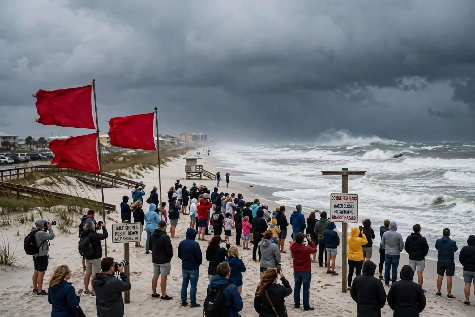
GULF SHORES, Ala. — Even with double red flags flying over Gulf Shores warning swimmers to stay out of the water, crowds turned out on the sand to watch Hurricane Sally stir up the Gulf of Mexico ahead of landfall. Locals and visitors alike came out to get a look at the crashing white caps and building surf before conditions deteriorated, despite the storm surge and heavy rain forecast for the Alabama coast. The sight of families, photographers and curious onlookers scattered along the beachfront became a familiar one in the hours before the storm arrived, as residents balanced fascination with the gathering weather against the warnings coming from city and county officials.
Double red flags mean the water is closed to the public — the highest hazard level used on Alabama beaches — as rip currents and pounding surf become life-threatening. The flag system used along the Gulf Coast is uniform from Orange Beach through Gulf Shores and across the state line into the Florida Panhandle, with green indicating calm conditions, yellow signaling moderate hazard, red warning of high hazard and double red signaling that the water is closed entirely. Purple flags, sometimes flown alongside the others, alert beachgoers to dangerous marine life such as jellyfish or stingrays. When double red flags are up, entering the Gulf is not merely discouraged — it is a violation of city ordinance in Gulf Shores, and lifeguards and police can order swimmers out of the water.
Sally’s approach was expected to bring days of rough seas, rising water and eventually tropical-storm-force winds to Baldwin County’s coastline. The storm had spent days crawling across the warm waters of the central Gulf of Mexico, a slow movement that forecasters warned would compound the dangers in two ways: it allowed the surf to grow taller and more violent with each passing tide cycle, and it meant that when the storm finally reached the coast, rain bands would sit over the same communities for an extended period rather than sweeping quickly through. Slow-moving Gulf storms are notorious for producing rainfall totals measured in feet rather than inches, and Sally was shaping up as exactly that kind of system.
Why Beachgoers Kept Coming to the Sand
Veteran Gulf Coast residents know the pull of a storm-watching excursion. Long before landfall, the Gulf takes on a dramatic appearance that locals say they rarely see any other time of year — fishing piers framed by heavy gray skies, waves stacking up in sets that roll far past the normal swash line, and seabirds riding winds that grow steadier by the hour. On the day before Sally’s expected arrival, the main public beach access points in Gulf Shores drew a steady stream of vehicles, and parking spots near the beach boardwalks filled quickly despite the closures in effect for the water itself.
Safety officials, however, stressed that standing on the sand is not without risk once a hurricane approaches. Storm surge can begin pushing water over dunes and onto beachfront roads well before tropical-storm-force winds arrive, cutting off access points and stranding anyone who lingers too long. Rip currents spawned by distant and nearby storms are already running hard while the surf builds, and even experienced swimmers who wade in knee-deep can be knocked down and pulled out. Emergency managers across Baldwin County repeated the same message throughout the day: the time to see the storm is from well inland, not from the waterline.
Officials urged anyone visiting the beach to stay off the sand and out of the water as the storm nears, and to monitor forecasts and local emergency guidance as conditions worsen. Gulf Shores city staff and Baldwin County Emergency Management Agency officials used social media, local radio and roadside messaging to keep residents and visitors informed about evacuation zones, shelter locations and the timing of expected deterioration. For a barrier-island community with a single connection to the mainland in some directions, the advice carried practical weight — once winds reach sustained tropical-storm force, bridges and causeways can be closed to traffic, and anyone who stayed too long risks being cut off until the storm passes.
A Community Long Familiar With Gulf Storms
Gulf Shores and the surrounding Baldwin County shoreline have been here before. The Alabama coast has taken direct hits and glancing blows from hurricanes numerous times over the decades, from Frederic in 1979, which hammered Mobile and Baldwin counties, to Ivan in 2004 and Katrina in 2005, which reshaped the coastline and taught hard lessons about storm surge, evacuation timing and building codes. Each storm has left its mark on how the community prepares. Condominium towers are built to modern wind standards, beachfront homes sit on pilings, and the city has invested heavily in warning systems and beach patrol coverage during the long tourist season.
That experience shapes how both officials and residents respond when a storm like Sally enters the Gulf. Longtime locals tend to fall into two camps — those who board up and leave early, and those who have ridden out enough glancing blows to feel confident staying, at least for moderate storms. The crowds on the beach ahead of Sally reflected the latter instinct, but city officials cautioned that every storm deserves respect regardless of its forecast category. A minimal hurricane moving at 10 miles per hour can produce flooding that rivals a much stronger storm, as Gulf Coast communities learned repeatedly in recent years.
The economic dimension adds urgency to the preparations as well. Gulf Shores’ economy is built on beach tourism, with the summer season and its string of festivals drawing millions of visitors to Baldwin County each year. A hurricane striking in early September — near the peak of the season — threatens not only homes and infrastructure but the remaining weeks of rental bookings that carry many local businesses through the slower winter months. Beach professionals, restaurant workers and charter operators all watch the same forecasts as the emergency managers do, knowing that a single landfall can wipe out a month of income even when property damage proves minor.
What Comes Next as Sally Closes In
Once conditions deteriorate, the crowds that gathered to watch the surf will have no reason to remain on the coast. City officials urged everyone — residents and visitors alike — to have a plan in place: know whether your location is in an evacuation zone, keep vehicles fueled, charge phones and devices, and stock several days of water, food and medications. Coastal Alabama’s evacuation routes, including the highways running north from the beach communities toward Interstate 10 and beyond, are familiar to anyone who has lived through prior storm scares, but timing matters. Roads that flow freely on a sunny warning day can jam badly when everyone leaves at once, and the window for safe travel closes well before the first squall lines arrive.
After the storm passes, the same beaches that drew storm watchers will become the focus of a different kind of attention. Post-landfall assessments typically document surge heights, beach erosion and damage to public infrastructure, and the Alabama coast has a long history of pumping sand back onto eroded beaches after major storms to protect the tourism economy. Utility crews from across the region stage in advance to restore power, and debris removal becomes the dominant visual along coastal streets for weeks afterward.
For the moment, the message from Gulf Shores officials remained simple: admire the Gulf from a safe distance, take the double red flags seriously, and follow emergency guidance as Sally approaches. The storm would provide more than enough drama on its own, they noted — the wise move is to watch it unfold from well inland, with family and property already secured, and to check official channels rather than the surf line for the latest on what the hurricane will bring to the Alabama coast.
The National Weather Service office responsible for the Alabama coast maintained a steady drumbeat of advisories as Sally organized, and forecasters emphasized that the cone of uncertainty still covered a wide stretch of the northern Gulf coastline. That uncertainty is part of what keeps emergency managers conservative in their messaging: a storm track that wobbles 50 miles east or west can be the difference between a damaging brush and a direct strike, and coastal residents are urged to prepare as though their community is the target. For Gulf Shores, sitting squarely in the forecast cone, that meant treating every subsequent advisory update with attention and completing storm preparations before nightfall rather than waiting to see where Sally ultimately came ashore.
Among the warnings repeated most often ahead of landfall was the danger of underestimating water. Coastal officials like to remind the public that in most hurricanes, it is the water — surge, waves and inland flooding — that kills more people than wind, and Sally’s slow movement made all three hazards more likely. Residents of low-lying streets near the bays and lagoons were encouraged to move vehicles and valuables to higher ground, boaters to secure vessels at double lines or pull them from the water entirely, and everyone along the coast to expect flooded roadways that may hide washed-out pavement beneath the surface. The crowds on the sand would soon give way to boarded windows and emptied parking lots, the familiar rhythm of a Gulf Coast community turning from spectacle to survival as the hurricane made its final approach.