Isaias Sting Jet Explained: How the Hurricane Hit and the Sunny, Warm Week Ahead
A look back at how Hurricane Isaias and its unusual sting jet brought 110-plus mph gusts to the Gulf Coast, plus the sunny, near-90-degree forecast and beach flag outlook for the week ahead.
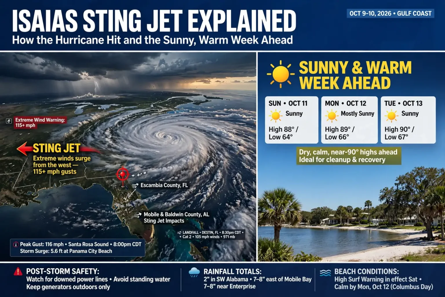
Hurricane Isaias will be remembered on the Gulf Coast as an unusual storm, one whose structure shifted as it made landfall and sent a “sting jet” of extreme winds across the western side of its circulation. Now that Isaias has moved out, forecasters expect a quiet, sunny and unseasonably warm stretch of weather for south Alabama and northwest Florida heading into the new week.
Isaias came ashore near Destin, Fla., at about 8:30 p.m. CDT Friday, Oct. 9, as a Category 2 hurricane. National Weather Service Doppler radar data put its maximum sustained winds at 105 mph at landfall, with an estimated minimum central pressure of 971 millibars, or 28.67 inches. The storm produced significant flooding, storm surge and wind gusts that exceeded 110 mph before racing inland through Alabama overnight.
By 1 a.m. Saturday, Oct. 10, Isaias had lost its tropical characteristics and become a post-tropical cyclone. By Saturday morning its maximum winds had dropped to 35 mph, and by early Saturday afternoon sustained winds were about 29 mph as the remnants moved north through the state.
From first hurricane to major hurricane
Isaias became the first hurricane of the 2026 Atlantic hurricane season on Wednesday night, Oct. 7, an unusually late date for a season’s first hurricane. It strengthened into a major hurricane, Category 3 or higher, on Friday morning before weakening slightly as it neared the coast. Isaias was the fourth named storm to make landfall in the United States this season and the strongest of them, following three short-lived tropical storms.
How Friday unfolded
The storm’s arrival played out over roughly eight hours on Friday, according to the timeline compiled by local meteorologists:
- Through midday: The outermost rain bands rotated through the area.
- Around 1 p.m.: Tropical storm conditions began at the coastline as more intense rain bands moved in.
- Around 3 p.m.: Stronger bands arrived, and the sting jet began, driving powerful winds in from the west and increasing winds on the storm’s west side, including Escambia County, Fla.
- Around 5 p.m.: The northern eyewall moved onshore along the northwest Florida coast.
- Around 7 p.m.: Extreme winds, storm surge and flooding were ongoing.
- 8:30 p.m.: Isaias officially made landfall at Destin as a Category 2 hurricane.
What the sting jet did
In a typical landfalling hurricane along the northern Gulf Coast, the strongest winds and highest surge are found on the storm’s eastern side, where the hurricane’s counterclockwise spin adds to its forward motion. Isaias did not follow that pattern neatly. The day before landfall, the National Weather Service had warned of the possibility of a sting jet, and on Friday morning forecasters said they were increasingly concerned about significantly stronger winds on the western side of the storm’s center, particularly across Mobile and Baldwin counties.
Starting in the middle of the afternoon, the sting jet moved in from the west. It enhanced winds on the storm’s west side beginning in Escambia County, Fla., then spread north into Escambia, Conecuh and Monroe counties in Alabama. At the same time, the hurricane’s center was moving into Santa Rosa and Okaloosa counties in northwest Florida. Between those two features, an Extreme Wind Warning was issued for expected winds of 115 mph or more, and that forecast came to pass. The weather service in Mobile reported a 116 mph gust in Santa Rosa Sound just after 8 p.m.
The result, local meteorologists said, was a hurricane whose structural changes during landfall placed the bulk of its impacts east of Mobile Bay, but on both the east and west sides of the system. That helps explain why Escambia, Conecuh and Monroe counties in Alabama, well inland and west of the landfall point, saw such severe wind damage and power losses, while the city of Mobile came through with comparatively scattered damage.
Where the rain fell
Wind shear from the west pushed most of Isaias’ rain east of Mobile Bay. Counties in southwest Alabama received about 2 inches of rain, while areas farther east picked up about 8 inches. Enterprise recorded 7 to 8 inches.
As the storm made landfall, Flash Flood Warnings and Flash Flood Emergencies were issued for northwest Florida counties and expanded inland as the evening went on. A Flash Flood Emergency is the weather service’s most serious flood alert, reserved for situations where severe flooding poses an imminent threat to life.
Storm surge along the coast
As is typical, the highest water was found near and east of where the center crossed the coast. A NOAA National Ocean Service water level gauge in Panama City Beach, Fla., reported a water level of 5.6 feet above mean higher high water, a measurement that approximates how deep the water was over normally dry ground in that area. In Destin, surge overtopped fences and beach walkways.
On the Alabama side, the picture was very different. On Mobile’s downtown riverfront, the lawns of Cooper Riverside Park were pristine Saturday morning, evidence that there had been little to nothing in the way of surge there.
Saturday: winds relax, skies clear
Conditions improved quickly Saturday along the coast as Isaias pulled away. Temperatures held in the 70s with steady winds from the northwest, and occasional gusts of up to about 30 mph were still possible across the area. Clouds lingered behind the departing system, with some sunshine expected in the afternoon and highs in the upper 70s to low 80s. A few light showers could not be ruled out, though most areas were expected to stay dry.
Farther north, the remnants of Isaias still packed a punch Saturday. The National Weather Service said bursts of heavy rain and wind gusts as high as 50 mph were possible, mainly in north and central Alabama, and flood watches remained in effect for those parts of the state. Northeast Alabama was under a high wind warning until 7 p.m. Saturday, and northwest and central Alabama were under a wind advisory until the same time. As of early Saturday afternoon, no tornadoes had been reported in Alabama.
The forecast: sunshine and near-90-degree highs
Full sunshine was expected to return Sunday, Oct. 11, as conditions get back to normal. For the week ahead, forecasters call for a calm stretch of weather that will feel very warm for mid-October:
- Highs: Upper 80s most days, with some spots approaching 90 degrees.
- Lows: Low to mid 60s, with lower humidity making nights comfortable.
- Skies: Mostly sunny days and mostly clear nights.
The dry, sunny pattern should be a welcome break for utility crews restoring power and for residents clearing yards and roofs. It also means heat will be a factor for anyone doing hours of outdoor cleanup, especially in homes still without air conditioning.
Beach conditions: red flags give way to calmer water
Even with the storm gone, the Gulf takes time to settle down. A High Surf Warning remained in effect through midnight Saturday night, and waves were expected to stay high even as they gradually subsided during the day. Double red flags, meaning the water is closed to the public, were to stay up Saturday because of a high rip current risk.
- Sunday: Single red flags are likely, signaling high hazard, though some yellow flags for moderate risk could be mixed in.
- Monday, Oct. 12 (Columbus Day): Gulf waters should be calm again, with green or yellow flags expected.
Beachgoers should check the flags posted at public beach accesses and follow lifeguard instructions. Rip currents can persist even on sunny days after a storm, and debris washed into the surf zone can pose additional hazards.
Staying safe after the storm
The weather service had advised residents to wait until after sunrise Saturday to assess damage, because extensive tree and power line damage made it dangerous to be out overnight and because the delay gave first responders time to reach the places they were needed most. As cleanup continues under clear skies, standard post-storm safety guidance still applies:
- Treat every downed power line as energized and report it to your utility or 911.
- Never run a generator indoors or in a garage, and keep it well away from doors and windows to prevent carbon monoxide poisoning.
- Avoid driving through standing water, which can hide washed-out pavement and debris.
- Take frequent breaks, drink plenty of water and work during cooler morning hours when clearing debris in the warm week ahead.
- Use caution with chainsaws and around trees that may be damaged or leaning.
Updated forecasts are available from the National Weather Service office in Mobile, and local emergency management agencies will continue posting information on road conditions and recovery as the region moves on from Isaias.