Dauphin Island Sea Lab study examines how in-water construction affects manatees
A Dauphin Island Sea Lab study in the Journal of Wildlife Management examines how bridge and in-water construction projects affect manatees in Alabama's.
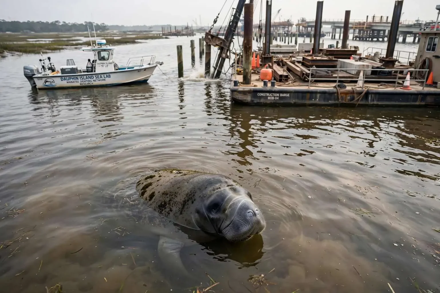
A new study from the Dauphin Island Sea Lab is shining a light on how bridge and other in-water construction projects affect some of the Gulf Coast’s most vulnerable wildlife. The lab’s Manatee Sighting Network recently published research in the Journal of Wildlife Management looking at how projects such as boat launches, docks, ports and dredging can impact manatees and other species in local waterways.
The research arrives at a moment when the question is not hypothetical. With several large water projects on the table locally — including the possible construction of a new Mobile River Bridge — the network contributes data that outlines how such work could affect the environment. The study gives planners, contractors and regulators a Gulf Coast-specific picture of what construction in manatee habitat actually does to the animals, drawn from more than a decade of local sighting records.
“Things like increased risks of vessel strikes … there is a lot more boating activity in the area. Also materials can block access to resources like vegetation for manatees. Or could potentially cause risks for entanglement or ingestion if construction materials are not discarded properly,” said Elizabeth Hieb with the Manatee Sighting Network. The risks she described track the stages of any marine construction project: more boats and barges mean more propellers in manatee habitat, staged materials can fence off the seagrass and vegetation manatees feed on, and debris left in the water can entangle or be swallowed by animals that graze by feel.
She added that pile driving and dredging can stir up the water and release contaminants that harm manatees’ food sources. Turbidity — the clouding of water by stirred-up sediment — smothers the submerged vegetation manatees graze on and can carry contaminants trapped in the bottom back into the water column, degrading the food supply exactly where construction is active.
The Mobile Bay context
With several large water projects on the table locally — including the possible construction of a new Mobile River Bridge — the network contributes data that outlines how such work could affect the environment. The proposed bridge and its approach span one of the busiest working harbors on the Gulf, where dredging already maintains shipping channels and in-water work of one kind or another is nearly constant. A project of that scale would multiply the activity the study flags: more barges, more pilings, more staging areas along the river and bay.
The network has documented manatee sightings increasing over the past decade, with an estimated 50 to 100 manatees residing seasonally in area waterways. West Indian manatees are Florida’s famous warm-water mammals, but each summer they range west along the Gulf Coast into Alabama waters, following warm weather and the seagrass and freshwater vegetation of Mobile Bay, the Mobile-Tensaw Delta and the rivers that feed them. Sightings reported by boaters and residents — the network’s core data source — have climbed steadily over the past decade.
The animals are also sticking around longer, and researchers say they can serve as a valuable indicator of ecosystem health. Manatees sit at the top of the story their habitat tells: they need warm water in the cool months, abundant vegetation to eat and calm passages to travel. Where manatees linger, those conditions exist; where they decline, something in the water has changed. That makes the animals a sentinel species for the Mobile Bay system — what harms them eventually registers on the rest of the estuary.
The Dauphin Island Sea Lab and its network
The Dauphin Island Sea Lab, located on the eastern end of Dauphin Island at the mouth of Mobile Bay, serves as Alabama’s marine science education and research institution, hosting university consortium programs and state-supported research centers. Its Manatee Sighting Network — the only one of its kind on the Gulf Coast outside Florida — collects and verifies sightings reported by the public, tracks the animals’ seasonal movements and has become the region’s repository for manatee data.
The network’s model depends on the public. Boaters, fishermen, kayakers and waterfront residents report sightings, often with photographs, and researchers confirm them and log the locations, dates and conditions. Over years, that crowd-sourced record becomes something no single research vessel could produce: a continuous picture of when and where manatees appear in Alabama waters, which is precisely the baseline a study of construction impacts requires.
Publishing in the Journal of Wildlife Management placed the network’s findings before the peer-reviewed audience that makes regulatory use of them possible. Federal agencies consult the published literature when they consult on endangered species — the West Indian manatee is protected under the Endangered Species Act and the Marine Mammal Protection Act — and a locally grounded paper gives Alabama’s projects a scientific reference Florida’s waters have long had.
What the risks mean in practice
The study’s catalog of impacts translates into conditions regulators can address. Vessel strike risk rises with activity, so construction windows, speed zones and lookouts are the standard mitigations; Hieb said training construction crews to watch for manatees, properly cleaning up materials and planning ahead can help reduce risks to the animals. Crew training converts the network’s research into practice on the water — workers who know what a manatee looks like at the surface, and who to call when one appears near active equipment, are the first line of protection the animals have during a project.
Material management is the other half of the prescription. Staging areas, moored barges and construction materials can function as barriers across channels manatees use, and debris that sinks or drifts — cable, netting, lumber, plastic — presents the entanglement and ingestion hazards Hieb described. Proper disposal and containment are not housekeeping details in manatee habitat; they are the difference between a project that coexists with the animals and one that injures them.
Planning ahead — the third element Hieb named — is where the study intends to make its mark. Knowing the seasonal patterns of manatee movement in Mobile Bay and the Delta allows projects to schedule in-water work around the months and locations where manatees are most likely present, rather than discovering the conflict mid-construction. The network’s sighting database gives planners that seasonal map, and the study packages it in a form permit reviews can cite.
For a species expanding its Gulf Coast range into Alabama waters, the local research matters precisely because the animals are new arrivals in meaningful numbers. Florida’s manatee protections grew from decades of study there; the Gulf Coast’s window to build its own understanding — before the region’s water projects multiply — is exactly the window this research is aimed at opening.
Warm water and the journey west
The seasonal manatee population Alabama hosts is an extension of a Florida story. West Indian manatees concentrate in Florida’s springs and power plant outfalls during winter, then fan out along the Gulf Coast as water warms, following vegetation and temperatures into Mississippi, Alabama and the Florida Panhandle’s western bays. Mobile Bay’s mix of seagrass beds, delta marshes and river systems offers summer habitat that has drawn more animals each year as Florida’s herds grow and range outward.
The network’s decade of records captured that expansion. Sightings once clustered in the warmest months now stretch deeper into spring and fall, and individual manatees have been photographed returning to Alabama waters across multiple years — evidence of animals that treat the region as routine range rather than rare excursion. The estimated 50 to 100 manatees residing seasonally in area waterways represents a small population by Florida standards and a significant one for a state where the species was once a novelty.
That range expansion also raises the stakes of every in-water project. A population of dozens is small enough that even a few vessel strikes or a degraded stretch of habitat registers at the population level, and the animals’ slow reproduction — a single calf after a year or more of gestation — means losses are not quickly replaced. Alabama’s manatees exist at the margin of the species’ range, and marginal populations are the ones conservation measures most easily save.
Manatees as an indicator species
Researchers’ characterization of manatees as an indicator of ecosystem health gives the study a significance beyond the species itself. Mobile Bay’s submerged vegetation — the seagrasses and freshwater grasses manatees graze — depends on water clarity, which in turn depends on how the region treats its sediment, its shoreline and its runoff. Turbidity and contamination that hurt manatee food sources also stress the fish nurseries, crab populations and waterfowl habitat the bay’s economy and ecology rest on.
That framing matters for how local residents read the research. A manatee sighting is often reported as a curiosity — a rare visitor in the bayou — but the network’s data reframes the animals as a measurement: their increasing numbers and longer stays indicate a bay system productive enough to support large herbivores, and the study’s warnings describe the pressures that could reverse it. Protecting manatees during construction is, in that sense, protecting the estuary’s own report card.
The public’s role in that system continues after the study’s publication. The network asks boaters and residents to keep reporting sightings, to give the animals space when they surface, and to follow posted zones around construction activity in the water. Each verified report feeds the same database the research was built on, sharpening the seasonal map the next project review will use — and keeping the Gulf Coast’s newest large mammal neighbors visible to the science meant to protect them.