Hurricane Sally’s Fort Morgan Damage Caught on Drone Video
Aerial video shot after Hurricane Sally shows torn-off roofs, damaged docks and sand-covered roads along the Fort Morgan Peninsula, part of widespread destruction the slow-moving storm left across coastal Baldwin County.
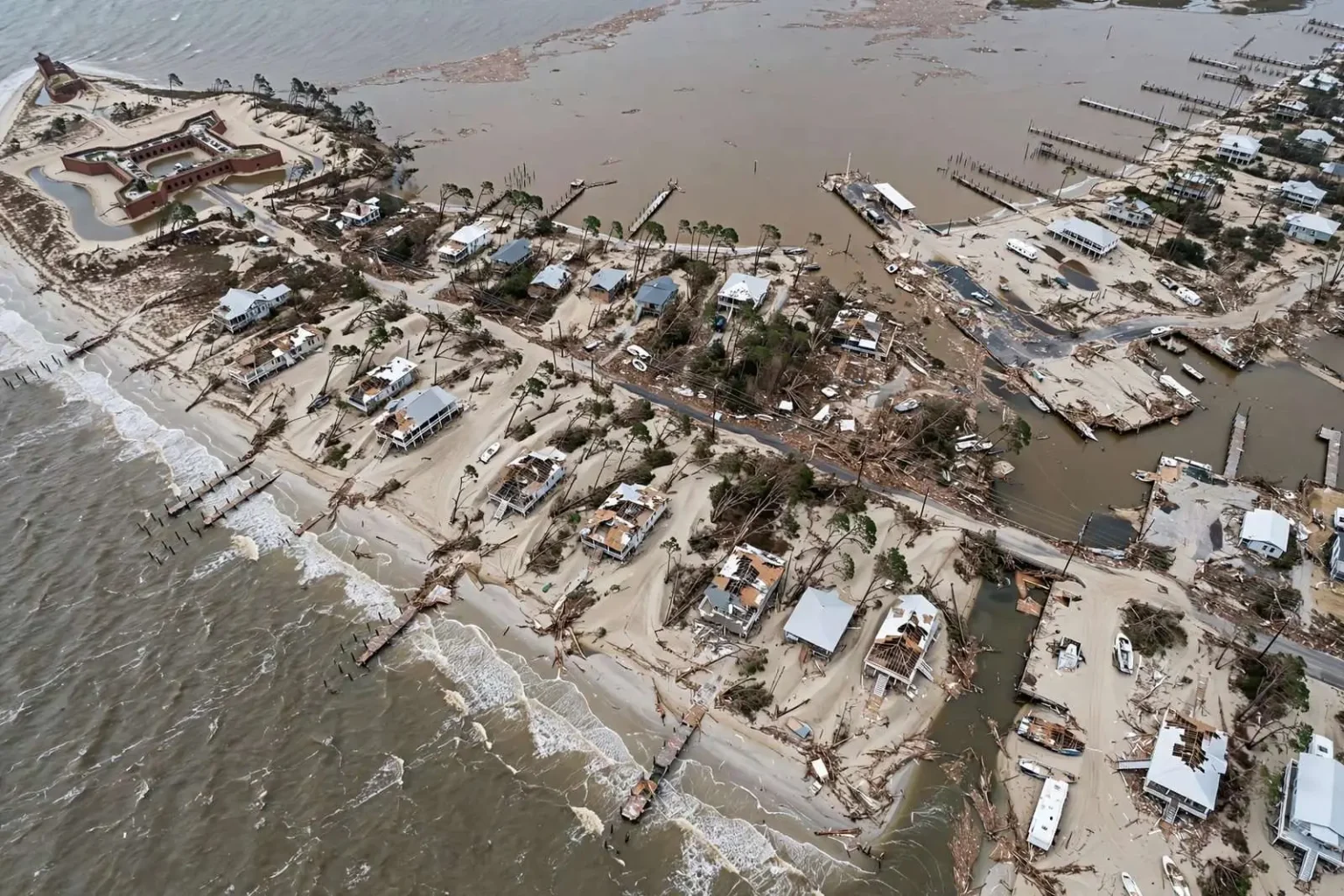
Aerial footage captured over Fort Morgan in the days after Hurricane Sally made landfall shows the scale of destruction the storm left behind along Baldwin County’s coastline, from splintered piers and stripped rooflines to sand-covered roadways and downed trees. The drone video, sweeping over neighborhoods that line the narrow peninsula, offered the first comprehensive look at damage that would take crews and residents weeks to fully assess.
Sally came ashore near Gulf Shores early Wednesday, Sept. 16, 2020, as a Category 2 hurricane with sustained winds near 105 mph, then slowed to a crawl over south Alabama and the Florida Panhandle, dumping as much as two and a half feet of rain in some spots and pushing a destructive storm surge into low-lying communities. The landfall point put the eyewall almost directly over the communities at the mouth of Mobile Bay, including Fort Morgan.
The slow-moving system gave the Gulf Coast an unusually long, grinding exposure to hurricane-force winds and rising water, and Fort Morgan, situated at the western tip of the Fort Morgan Peninsula where Mobile Bay meets the Gulf of Mexico, took a direct hit from both. A hurricane’s most destructive wind field sits in the eyewall’s leading quadrant, and Sally’s crawl meant those winds hammered the same coastline hour after hour rather than passing in a single night.
Water attacked from two directions at once. Storm surge from the Gulf pushed into the homes and campgrounds on the peninsula’s southern shore, while the same onshore winds piled Mobile Bay’s waters against communities on the bay side, a double inundation that only the peninsula’s most exposed geography experiences.
Drone video shot in the storm’s aftermath shows homes along the peninsula with roofs peeled back, docks reduced to pilings, and stretches of Alabama’s coastal highway buried under sand pushed inland by the surge. The images documented a distinctive pattern of Sally’s damage: rather than leveling neighborhoods, the storm systematically stripped everything not structurally anchored — porches, roof coverings, piers, boats, vegetation — while burying what remained under feet of sand and debris.
Days of assessment and cleanup
The footage also captured the storm’s effect on the landmarks that define the peninsula. The ferry landing that connects Fort Morgan to Dauphin Island across the mouth of the bay, the campgrounds and beach houses that line the shore, and the historic fort itself all sit within the surge zone, and the aerial perspective made clear how completely the storm had rearranged the line where land meets water.
Debris fields lined yards and roadsides, and several waterfront structures sustained damage to pilings and foundations from the pounding surf. Along a peninsula where so much of the property value sits at the water’s edge, foundation damage carries particular weight: a house can be repaired, but a undermined foundation can render a structure unrecognizable in insurance terms.
Crews spent the following days clearing roads and assessing which homes were safe to reoccupy. With the peninsula’s single access route choked by sand, downed trees and storm debris, getting road-clearing equipment to the far end of Fort Morgan was itself a logistical operation, and utility crews had to follow the road crews before power could be restored to the westernmost properties.
In Mobile and the surrounding communities, the day after landfall was a morning of chainsaws. Canopy streets that had shaded the city for generations were blocked end to end with fallen oaks and pines, and residents emerged to find the familiar geography of their neighborhoods temporarily erased — driveways unreachable, intersections impassable, power lines draped across lawns like garlands.
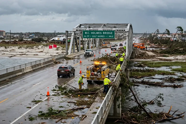
The storm was blamed for at least two deaths in Alabama and Georgia, and its effects reached far beyond the immediate coastline. By Thursday afternoon, more than half a million customers across Alabama, Georgia, Florida and Louisiana were without power, according to outage tracking data, as utility crews worked to restring downed lines and clear fallen trees from roads across Baldwin and Mobile counties.
The outage numbers reflected Sally’s signature damage: trees. Unlike the catastrophic structural losses of a Category 4 or 5, a slow-moving Category 2 can fell an extraordinary number of trees — saturated soil gives roots nothing to grip, and hours of sustained winds stress trunks and limbs until lines, cars and homes pay the price. Across Mobile and Baldwin counties, nearly every neighborhood lost power, some for well over a week.
Sally’s landfall came in a 2020 hurricane season so relentless that names had to be supplemented from the Greek alphabet for the first time since 2005. For Gulf Coast residents, the season’s speed compressed the usual recovery rhythm — many families along the Alabama coast were still repairing damage from earlier storms when Sally arrived, and the psychological toll of back-to-back seasons was part of the story the drone footage could not show.
Even after Sally’s center pushed inland and weakened, its remnants continued to cause problems well beyond south Alabama. Heavy rain bands trailing the storm brought flooding concerns to Georgia and the Carolinas, and forecasters warned that swollen rivers across the Southeast could keep flood conditions dangerous long after the winds died. Slow-movers like Sally are defined as much by their rain as their wind, and the storm’s moisture footprint stretched hundreds of miles inland.
Why Fort Morgan was so exposed
The Fort Morgan Peninsula occupies a unique and vulnerable position on the Alabama coast. Roughly 20 miles of narrow barrier terrain extend west from Gulf Shores toward the historic fort that gives the community its name, separating the open Gulf from the protected waters of Mobile Bay. The geography makes the peninsula one of the most scenic addresses in Alabama — and among the first places any hurricane approaching from the south will strike.
The community’s mix of older beach cottages, modern elevated homes and waterfront campgrounds means hurricane damage there is never uniform. Elevated construction on pilings, common in newer coastal builds, rode out Sally’s surge far better than ground-level structures, and the drone footage illustrated that divide street by street: neighboring homes at different elevations could emerge from the same storm in categorically different condition.
Mobile Bay’s shape amplifies the bay-side threat in storms like Sally. The bay is wide and shallow at its mouth, and sustained winds blowing from the south stack water into the narrow upper reaches of the bay and against its eastern and western shores. Communities on both sides of the bay reported surge flooding during Sally, but the peninsula, standing unprotected between the two water bodies, received the full combination.
Sally’s landfall as a Category 2 with 105 mph winds also underscored the volatility of storm intensity near landfall. Forecast tracks had wobbled across the northern Gulf for days before landfall, and a last-hours jog to the east of some projections shifted the most destructive winds onto the Alabama coastline rather than the Florida Panhandle communities that had expected the brunt. Small changes in a hurricane’s final approach can redraw the damage map entirely.
Recovery and what comes next
In the weeks after the drone footage was captured, the recovery unfolded in the familiar sequence of Gulf Coast storms: insurance adjusters moving street to street, debris haulers clearing the sand and splintered lumber, utility crews restoring power pole by pole, and families deciding whether to rebuild on land the storm had just demonstrated it can claim.
Sally’s rain totals belong in any accounting of the storm. Two and a half feet of rain — thirty inches — is a year’s worth of precipitation in many places, delivered in roughly two days, and the flooding it produced well inland claimed homes that never felt hurricane-force wind. Emergency managers across south Alabama ranked Sally’s flooding among the worst of any storm in recent memory, a consequence of the same slow crawl that made its winds so punishing on the coast.
The storm also renewed long-running conversations about building standards, flood insurance and coastal development along Alabama’s beaches. Every hurricane that strikes the Fort Morgan Peninsula tests the engineering decisions of the decades before, and Sally’s damage patterns — surge-driven foundation failures, wind-stripped rooflines, sand-buried roads — gave engineers and planners fresh data for the next round of building codes and dune restoration debates.
For the residents who lived through it, though, the drone video’s value was simpler: it let them see their neighborhoods from the air, understand the full geography of what had happened to them, and begin the work of putting the peninsula back together. Sally would be remembered along the Gulf Coast not as the most violent storm of its era, but as one of the most persistent — a hurricane that stayed long enough to touch everything, and left behind months of work for everyone it touched.