Gulf Coast Weather Forecast: Sunny Week Ahead for Mobile, Baldwin; Rip Currents a Threat
Sunshine, cool mornings and highs warming toward the lower 80s are in store this week for Mobile and Baldwin counties, but a high rip current risk keeps Gulf swimming dangerous into early week.
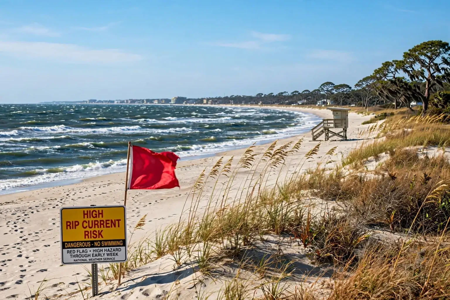
MOBILE, Ala. — The Gulf Coast weather forecast for the week of Oct. 18 reads like a fall postcard: abundant sunshine, crisp mornings and comfortable afternoons from Mobile to the beaches of Baldwin County. The one major exception is the water, where a high risk of dangerous rip currents and rough marine conditions will linger into early this week.
Afternoon temperatures will climb gradually through the week, reaching the lower 80s in some spots by Friday, Oct. 23. Even so, humidity is expected to stay relatively low, keeping the warmer days pleasant rather than muggy.
For residents across southwest Alabama, northwest Florida and southeast Mississippi, that adds up to an ideal stretch for yard work, festivals, football and other outdoor plans, as long as beachgoers respect the surf.
Sunday, Oct. 18: Chilly Start, Sunny Afternoon
Clear skies and cool, dry air set the stage for a chilly start to Sunday, Oct. 18. Overnight lows were forecast to dip into the upper 40s and lower 50s for most communities, with some inland locations falling into the middle 40s. Near the beaches, readings were expected to hold a bit warmer, mainly in the middle to upper 50s.
Winds were expected to ease overnight farther inland, though breezy conditions continue along the immediate coast and over the Gulf. Away from the beaches, it is a good time to open the windows and let the cool fall air in.
Sunday afternoon is shaping up to be another beautiful fall day. Temperatures will climb into the upper 60s and lower 70s under plentiful sunshine, and there is virtually no chance of rain for most communities.
A northeast breeze will continue through the day, with occasional gusts around 20 mph across much of the region. Locations closer to the coast could see gusts approaching 30 mph. Despite the wind, conditions should be excellent for festivals, sporting events and other outdoor activities, with mild temperatures and low humidity making for a comfortable afternoon.
The cool pattern continues Sunday night. Lows will fall back into the 40s in some inland communities and into the lower to middle 50s closer to the coast.
Monday Through Wednesday: Sunshine and a Slow Warm-Up
High pressure will keep the northern Gulf Coast mostly dry from Monday, Oct. 19, through Wednesday, Oct. 21. Expect plenty of sunshine each day, with afternoon highs creeping upward as the week goes on.
High pressure is typically associated with sinking air, which discourages cloud formation and rain. When a dome of high pressure settles over the region in the fall, it often brings exactly the kind of weather in this forecast: clear skies, low humidity, wide swings between cool mornings and mild afternoons, and little to no rain.
Dry air also cools off quickly after sunset, which is why mornings this week will feel so much cooler than the afternoons. A spread of 20 degrees or more between the morning low and the afternoon high is common in this kind of pattern, especially inland.
- Monday, Oct. 19: Sunny, with highs in the lower to middle 70s.
- Tuesday, Oct. 20: Sunny, with highs in the middle to upper 70s.
- Wednesday, Oct. 21: Sunny, with many communities approaching 80 degrees.
Mornings will stay noticeably cool, especially away from the coast. Lows will generally range from the 40s to the lower 50s inland, while coastal areas remain a little milder.
Winds should also become lighter as the week moves along, making conditions increasingly pleasant for outdoor plans. That is good news for anyone hoping to tackle fall yard projects, take an evening walk or spend time at a park.
Thursday and Friday: Warmer Afternoons, Low Humidity
The warming trend will continue Thursday, Oct. 22, and Friday, Oct. 23, with afternoon highs returning to around 80 degrees across much of the area. Some western and inland communities could reach the lower 80s, while spots closer to the beaches will generally top out in the upper 70s.
Although afternoons will be warmer than this weekend, forecasters are not expecting a significant return of Gulf moisture or the oppressive humidity common earlier in the season. That should keep it feeling relatively comfortable even as temperatures climb.
Overnight lows will rise gradually, but most communities should still wake up to temperatures in the 50s each morning.
The extended outlook remains overwhelmingly sunny and dry. That includes Friday evening, Oct. 23, when high school football teams across the region take the field, and the start of next weekend, Oct. 24-25. No significant cold fronts or widespread rain events are expected through the seven-day forecast.
Beaches and Marine: High Rip Current Risk Into Early Week
While the weather on land will be excellent, conditions along the beaches and offshore will be far less friendly. A high risk of dangerous rip currents began Saturday night, Oct. 17, and is expected to continue into early this week along area beaches, including those in Gulf Shores, Orange Beach, Fort Morgan and Dauphin Island.
Strong northeast to easterly winds over the Gulf are driving hazardous surf, even under sunny skies. Swimming in the Gulf is strongly discouraged while the high rip current risk remains in place.
Water temperatures have cooled into the middle 70s, but cooler water does not make rip currents any less dangerous. Rip currents can form on clear, calm-looking days and can quickly pull even strong swimmers away from shore.
Boaters also need to use caution. Strong winds and rough seas will persist across the open Gulf, with gale-force conditions possible offshore Saturday night. Small Craft Advisory conditions are expected to continue into the week, and area bays and sounds will remain choppy to rough, particularly in more exposed locations.
How to Stay Safe in the Surf
Before heading to the beach this week, check local beach warning flags and posted conditions. Along much of the Gulf Coast, a red flag signals high hazard from surf or currents, and double red flags mean the water is closed to the public.
The National Weather Service offers several tips for anyone caught in a rip current:
- Stay calm and float. Rip currents pull people away from shore, not under the water. Floating helps conserve energy.
- Don’t fight the current. Avoid swimming directly back toward shore against the pull.
- Swim parallel to the shoreline. Once out of the current, angle back toward the beach.
- Signal for help. If you can’t reach shore, float or tread water and yell or wave for help.
If you see someone else in trouble, the agency advises getting help from a lifeguard or calling 911 if no lifeguard is present. Throw the person something that floats and tell them to swim parallel to the shore, but do not enter the water without a flotation device or attempt a rescue on your own.
Boaters heading out this week should check the latest marine forecast before departing, carry life jackets for everyone on board and consider postponing trips into open Gulf waters until winds and seas subside.
Tropics Quiet for the Northern Gulf
The Atlantic hurricane season runs through Nov. 30, and forecasters continue to monitor the tropics. For now, however, there are no tropical systems posing a threat to the northern Gulf Coast.
The Gulf is expected to stay quiet for the next seven to 10 days, with no tropical impacts expected locally. That is welcome news for communities in southwest Alabama that are still recovering from Hurricane Isaias, which made landfall near Destin, Fla., on Oct. 9.
Planning Your Week Outdoors
With dry weather and mild temperatures in the forecast, this week offers a strong window for outdoor plans across Mobile and Baldwin counties. A few things to keep in mind:
- Layer up early. Mornings in the 40s and 50s can feel chilly, especially for bus stops and early workouts, while afternoons warm into the 70s and lower 80s.
- Plan for breezy beaches. Coastal winds will stay gusty early in the week, so secure umbrellas and canopies.
- Stay out of the Gulf while the rip current risk is high. Enjoy the sand, but leave the swimming for calmer days.
- Expect dry Friday night lights. High school football on Friday, Oct. 23, looks dry with comfortable temperatures.
The Week at a Glance
- Sunday, Oct. 18: Sunny and breezy; highs in the upper 60s to lower 70s; lows Sunday night in the 40s inland and lower to middle 50s near the coast.
- Monday, Oct. 19: Sunny; highs in the lower to middle 70s.
- Tuesday, Oct. 20: Sunny; highs in the middle to upper 70s.
- Wednesday, Oct. 21: Sunny; highs near 80 in many communities.
- Thursday, Oct. 22, and Friday, Oct. 23: Sunny and warmer; highs around 80, with lower 80s possible inland and upper 70s near the beaches; morning lows mostly in the 50s.
- Saturday, Oct. 24: Sunny and dry to start the weekend.
The forecast also offers a break for southwest Alabama communities still cleaning up from Hurricane Isaias. Dry weather allows crews to keep working on debris removal and repairs without rain delays, and cooler mornings make outdoor labor a little easier for residents still clearing yards.
Residents should continue to check the latest forecast for updates, particularly for changes in beach and marine conditions as winds diminish later in the week.