Years On, Mobile Still Argues Over Whether the I-165 Expressway Was Worth It
With a new Mobile River bridge under discussion, longtime observers looked back at the bruising 1980s battle over an elevated downtown expressway and asked whether time had settled the question.
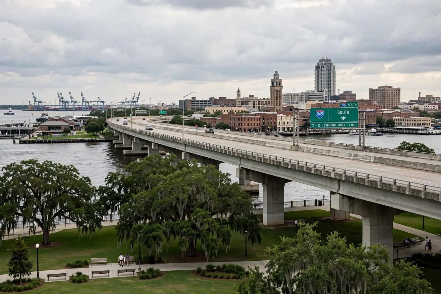
As Mobile weighed the prospect of a costly new bridge across the Mobile River, civic figures found themselves relitigating an older argument: whether the elevated I-165 expressway, and the decision decades earlier to reject a raised roadway along the downtown waterfront, had been wise. The publication put the question to a number of people who had watched the saga unfold. Their answers revealed that, even years later, no clear consensus had formed.
The occasion made the old debate relevant again. With planners narrowing the choices for a new interstate crossing of the Mobile River — the long-debated replacement for the Wallace Tunnel and the I-10 bottleneck it carries — every argument about elevated highways, waterfront access and through-traffic was being reopened, and the veterans of the original fights were being asked what they had learned.
A Bad Idea, Then and Now
Attorney David A. Bagwell was unequivocal. For roughly 16 years, his office window had looked down on Water Street, and he had thought an elevated Water Street was a bad idea at the time. He remained pleased, he said, that he had been proven right. The view from that window — over the street where Mobile’s riverfront commerce began and where its redevelopment would later take hold — gave him a front-row seat to what the city would have sacrificed: the open approach to the river, the row of historic buildings, and the human scale that a double-decked highway would have buried in shadow.
Bagwell’s position reflected the consensus that eventually prevailed downtown. Instead of the elevated roadway, the city and state rebuilt the waterfront at grade, moved the port’s public access to the river, and created the riverfront parks and developments that now anchor the southern edge of downtown. What might have been a concrete canyon became Cooper Riverside Park, and the blocks behind it appreciated in exactly the way cities do when a highway does not divide them from their water.
Others were far less certain that anyone had been vindicated. Businessman Trip Pittman offered a lighter assessment, joking that he thought of I-165 as his private road and short cut toward Bay Bridge Road and Baldwin County, and wondering aloud what the actual traffic count on the route might be. The joke carried a point that planners take seriously: I-165, the five-mile connector linking I-65 to downtown, has never carried the traffic volumes its champions projected, and part of the town’s dispute was over whether that shortfall proved the concept wrong or the signage inadequate.
The Right Design After All?
One local businessman argued that, given the way downtown had evolved, the right design had been chosen. His sharper criticism was reserved for the I-10 crossing of the bay, with its tight corner and only two lanes beneath the river. Rather than build a new bridge to relieve the tunnel, he suggested, the community might be better served by a second tunnel, which would avoid disturbing the waterfront or interfering with flight operations at Brookley.
Each element of that argument mapped onto a real constraint. The Wallace Tunnel carries I-10 through a bend beneath the Mobile River in two lanes each way, a geometry that produces the daily backups for which downtown Mobile is notorious. A high-level bridge over the river — the option that eventually took shape as the proposed Mobile River Bridge — would clear the port’s shipping channel, but it would tower over the historic district, take property, and deliver interstate traffic onto elevated approaches through the neighborhoods east of downtown. A second tunnel, by contrast, would add capacity below ground, leaving the skyline, the riverfront and the flight paths around the Brookley Aeroplex — the industrial airport whose approach corridors constrain tall structures across the southern peninsula — untouched.
Tunnel opponents have their own ledger: cost per mile far above a bridge, decades of construction under an active harbor, and the questions of ventilation and safety that follow any enclosed roadway. The exchange made plain that in Mobile, the choice was never simply engineering; it was a referendum on what the city’s waterfront was for.
No Verdict Yet
A veteran of the original fight recalled being among the proponents of the raised I-165 expressway, alongside other business and roadbuilding figures of the era. Even so, he was careful not to claim victory. He did not know that either side had been proven wrong, he said, noting that dumping the traffic onto Water Street had not turned out as badly as he had feared.
The reason, he suspected, was that for years the state highway department had declined to post I-165 markers on I-65, leaving many drivers unaware of the route. Through traffic bound for downtown or the Eastern Shore stayed on the interstate mainline or funneled into the tunnel backups, while the purpose-built expressway ran half-empty alongside. Newer signs had begun to appear, he observed, and it was possible the expressway’s supporters would be vindicated in time. Or, he allowed with characteristic candor, maybe not.
The honesty was itself telling. In most American cities, the urban expressway fights of the mid-twentieth century produced winners and losers that history judged quickly — neighborhoods cut in two, waterfronts buried, downtowns bypassed. Mobile’s variant ended ambiguously: the elevated road that was built carried too few cars, the elevated road that was stopped would have carried too many, and the tunnel that neither project was meant to relieve still backs up every afternoon.
The participants themselves illustrated why the question stayed open. The man whose office overlooked Water Street judged the outcome by what the riverfront became; the businessman who used the expressway as his private shortcut judged it by what the road carried; the veteran of the original campaign judged it by whether his side’s predictions came true. Each standard is defensible, and they do not converge — which is why, decades on, the same roads could produce such different verdicts from people who watched the same events.
Echoes in a New Fight
The exchange carried more than nostalgic value. With planners narrowing the choices for a new interstate crossing of the Mobile River, the unresolved lessons of the I-210 and I-165 episodes hung over the discussion. The I-210 study, the decades-old proposal for a full limited-access loop through and around the city, had been shelved after fierce opposition; I-165 was built as the truncated remnant of that larger vision. Every map drawn for the new crossing was, in that sense, a revision of plans the city had already fought over once.
Supporters of limited-access design still argued that feeding interstate traffic into local streets at ground level defeated the purpose of an interstate meant to move non-local traffic quickly through an area. Truck traffic from the Port of Mobile, freight moving between I-65 and the beaches of Baldwin County, and through travelers on the I-10 corridor all funnel past downtown; the question was whether they should pass above it, beneath the river, or through its streets. Opponents countered that the barrier never built had spared downtown from decades of blight and made possible the redevelopment that followed — the hotels, restaurants and residences of a revived lower Dauphin district that an elevated roadway would have shadowed.
The new crossing debate folded in one further element the old fights lacked: tolls. A new bridge or tunnel of the scale required would almost certainly carry a user charge, adding a question — who pays, and how much — that the I-165 generation never faced. Tolls sharpened the coastal dimension too, since Baldwin County commuters crossing the bay daily would bear the charge most often, and eastbound and westbound objections did not always match.
More Than Traffic
Whatever the merits, the debate underscored a durable truth about Mobile’s relationship with its waterfront: decisions about roads and bridges were never merely about traffic, but about the shape and character of the city itself. A port city’s riverfront is simultaneously a workplace, a destination, a view and a right of way, and each of those uses has a constituency. Engineering studies can rank alignments and forecast volumes; they cannot settle what a city wants to be when it looks at its own river.
That is why the participants’ arguments reached past geometry into memory. Bagwell did not argue that an elevated Water Street would have carried traffic badly; he argued it would have ruined a street he had looked down for sixteen years. The tunnel critic did not dispute that the corridor needed capacity; he argued that a bridge would disfigure the waterfront and clip the approaches to Brookley. The old expressway champion did not claim the numbers had worked; he argued the road had never really been tried, unmarked and unnoticed on the mainline. In Mobile, every road proposal arrives wrapped in a history the numbers cannot capture.
As one participant put it, the community had reason to weigh such choices with care, because the consequences would outlast the arguments. The I-165 generation built a road whose usefulness is still debated; the no-build generation preserved a waterfront whose value no one disputes. Somewhere between those two verdicts, Mobile would have to decide what to build next — and live with it far longer than anyone would be discussing it.