Mobile Plots a 98-Acre Waterfront Park on the Bay: ‘Brookley by the Bay’ Takes Shape
Mobile is planning Brookley by the Bay, a 98-acre regional park on Mobile Bay near Brookley Aeroplex. Here's what residents want there.
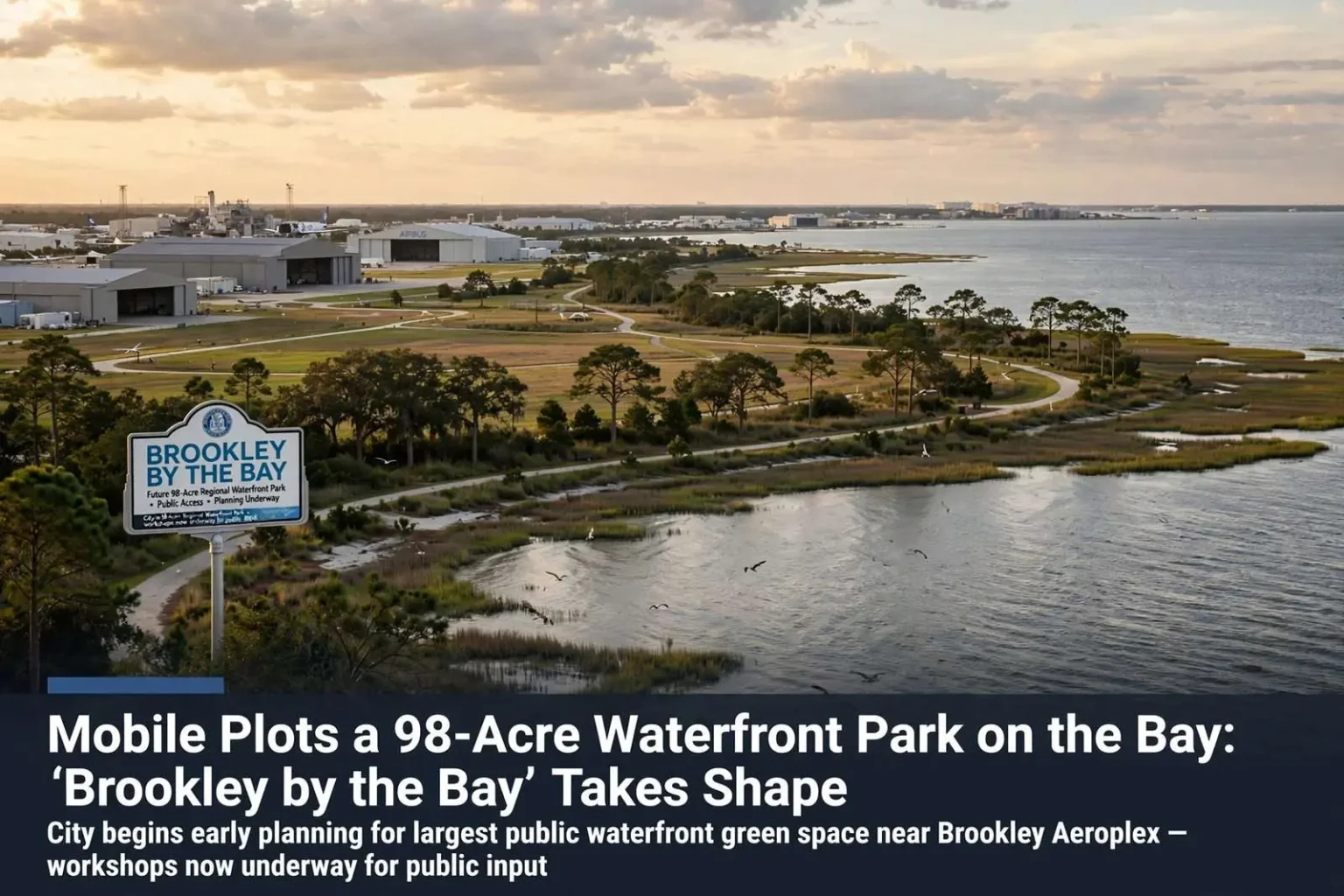
Mobile is beginning work on what could become its newest and largest waterfront green space: a 98-acre park along Mobile Bay near Brookley Aeroplex that city officials are calling “Brookley by the Bay.” The project would rank among the largest public waterfront undertakings in the city’s modern history, converting a stretch of the bay’s western shoreline into parkland at a scale Mobile has never reserved for public use.
The site’s sheer size sets the effort apart. Mobile’s existing waterfront public spaces — the riverfront improvements downtown, the Kaisho Garden, small neighborhood parks along the shore — operate on a fraction of 98 acres. A park of this scale near the aeroplex would put public access on a bay shoreline that has for decades been dominated by industrial and aviation uses rather than open space, and it would do so in one of the fastest-developing corridors in the city.
Residents weigh in on what belongs on the waterfront
City leaders hosted an evening workshop to gather public input while planning is still in its early months. Shonnda Smith, deputy executive director of public works, said the vision is for a true regional park — a destination that draws visitors from across the area rather than serving only nearby neighborhoods. The distinction matters: a neighborhood park serves a subdivision, but a regional park is designed for the whole metropolitan area, with amenities and parking sized for visitors from Saraland to Tillman’s Corner and beyond.
The suggestions coming from residents have been ambitious. Beaches and fishing piers topped many wish lists, but Smith cautioned that planners first have to assess what the shoreline can actually support. Any amenity built on the bay has to withstand hurricanes and tropical weather, she noted, or the city will find itself rebuilding it after every storm. That reality shapes every waterfront project on the northern Gulf Coast, where storm surge, wave action and hurricane-force winds can destroy in a night what took years to build. Planners must weigh the appeal of water’s-edge amenities against the maintenance costs of replacing them after each hurricane season — a calculus familiar to every Gulf city that has built on the water.
A shoreline with a working past
The land near Brookley Aeroplex carries the imprint of Mobile’s aviation history. The aeroplex grew out of the former Brookley Air Force Base, a massive World War II-era installation that was among the area’s largest employers until its closure reshaped the city’s economy in the 1960s. The site’s conversion to civilian use, and its later rebirth with Airbus assembly operations, has made the surrounding corridor one of Mobile’s most active redevelopment zones — and the prospect of a 98-acre park adds a public dimension to growth that has so far been mostly industrial and commercial.
Redevelopment interest along that stretch of the bay has grown steadily, and the park would anchor it with something the corridor otherwise lacks: publicly accessible shoreline. City officials hope the green space will become a signature public asset on Mobile Bay, the kind of destination that gives the city an open-air landmark on the water.
More chances to comment
Tuesday’s session was only the start of the engagement process. The city planned additional workshops in the weeks ahead for anyone who missed the first meeting, and residents can also submit ideas directly to the project team by email. The multi-channel approach reflects lessons learned from other large civic projects: input gathered only at a single meeting reflects only the people who could attend on a weeknight, while an open email channel catches shift workers, parents of young children and residents across the bay who care about the waterfront but could not drive to the workshop.
Early-phase input is also where the biggest decisions get made. Once master plans harden into renderings, the public conversation shifts from “what should be there” to “what went wrong,” which is why the city is collecting ideas while the site is still a blank slate. Beaches, piers, trails, playgrounds, boat launches and event lawns can all be laid out at 98 acres; the sequencing of the workshops lets planners see which amenities generate the most support and which face practical obstacles along the shoreline.
What a regional park would mean for Mobile
A completed park at this scale would change how Mobile uses its bay frontage. Today, most residents experience Mobile Bay from a handful of points — the Causeway, the Fairhope pier across the bay, public accesses in south Mobile County — rather than from a major park within the city limits. A 98-acre green space near Brookley would put birdwatching, fishing, picnicking and bay-view recreation minutes from midtown, with the potential to host festivals, markets and community events that smaller parks cannot accommodate.
The economic logic follows the recreational one. Waterfront parks elsewhere on the Gulf Coast have proven reliable engines for surrounding investment, drawing joggers, tourists and families who in turn support nearby restaurants and businesses. Mobile’s own riverfront redevelopment downtown demonstrated the pattern on a smaller scale; a bayfront park multiplies the drawing power by adding open water views, breezes and space.
The planning process is still in its early months, and no timeline for design or construction has been announced. But the scale of the ambition is now public: nearly 100 acres of Mobile Bay shoreline, reserved for the public, shaped by the residents who attended the first workshop and the thousands who will weigh in before the first trail is laid. City officials intend for the process to be deliberate — assessment of the shoreline, more workshops, emailed ideas — because a park built to survive Gulf Coast weather is a park built to last for generations.
Building for the storms
Smith’s caution about hurricane resilience deserves emphasis, because it will likely determine which wish-list items survive into the final design. Gulf Coast waterfront structures face a punishing cycle: salt-water corrosion, subtropical sun, storm surge and the occasional direct hit from a major hurricane. A fishing pier on Mobile Bay must be engineered for wave loads as well as foot traffic; a beach must be designed with the expectation that sand migrates after every big blow; and any pavilions or bathhouses must either be built to storm-hardened standards or priced for eventual replacement.
Other Gulf cities’ waterfront parks offer a working playbook. The most durable designs concentrate hardened structures on higher ground, keep the water’s edge natural or minimally built, and use native plantings and marsh edges to absorb wave energy. Those choices cost more up front and can disappoint residents hoping for boardwalks to the horizon, but they determine whether a park reopens the weekend after a storm or spends two years on a federal reimbursement list.
For Mobile, the 98-acre scale provides room to do both — space enough for storm-resistant amenities and for the natural shoreline that protects them. The city has not said how the project will be funded across design and construction phases, and large waterfront parks typically draw on a mix of city capital funds, state grants and federal programs for coastal access and resilience. What is certain is the starting point: a workshop full of ideas, a wish list topped by beaches and fishing piers, and an official commitment to find out what the shoreline itself will bear.
The site’s location next to Brookley Aeroplex puts the future park along a stretch of the bay that has seen significant redevelopment interest, and city officials hope the green space will become a signature public asset on Mobile Bay. Between the workshops to come, the email channel for ideas, and the shoreline assessments that will test every suggestion, Mobile residents will have more influence over this park than over any public space the city has planned in decades — and the park they get will be the one they asked for, built to face the water and the weather.
From airfield to public shoreline
The aeroplex’s story gives the park project its second layer of significance. Brookley Field was the hub of Mobile’s wartime aviation economy, employing tens of thousands at its peak and drawing workers to the city during World War II. Its postwar closure was an economic wound that took decades to heal, and the gradual redevelopment of the site — including the arrival of commercial aerospace manufacturing that returned thousands of jobs to the corridor — is one of the region’s defining second acts. A public park on the adjacent bayfront would complete that transformation, converting land that once served national defense into open space serving everyday residents.
The timing also matters. Corridor development has accelerated in recent years, and waterfront land near an urban core is the kind of asset cities rarely get a second chance to reserve. Once surrounding parcels are committed to private development, the opportunity to create a 98-acre public destination disappears permanently. By starting the planning process now — and by asking residents what they want before any master plan exists — the city is effectively locking in public access to the bay for future generations of Mobile residents.
For now, the project remains in its listening phase, with more workshops on the calendar and an open invitation to email ideas to the project team. The wish lists gathered so far — beaches, fishing piers, the dream of a destination park — will be tested against shoreline assessments and storm-resilience standards, and the final design will be whatever survives that conversation between ambition and geography. That conversation is exactly how city officials want the park built: slowly, publicly and with the whole region in mind.