Mobile residents pack community meeting on Perch Creek Parks plan
Mobile residents filled a community meeting to discuss the Perch Creek Parks plan, with ideas for McNally Park, Helen Wood Park and improved access to.
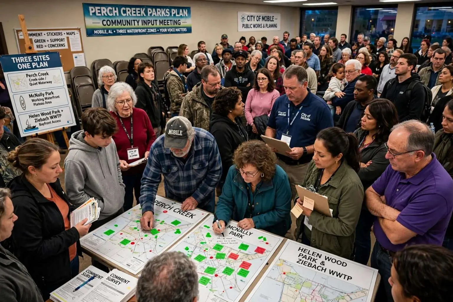
MOBILE, Ala. — A standing-room-only crowd turned out for a community input meeting on the future of the Perch Creek Parks project, with residents weighing in on how three waterfront areas should be developed. The gathering filled the meeting space well beyond what organizers had planned for, a turnout that reflected how much interest Mobile residents have in the future of their shoreline. Attendees reviewed early concepts for the sites and left comments that planners will use to shape the next round of design work.
The plan centers on three zones: Perch Creek, McNally Park, and Helen Wood Park, the latter paired with the Ziebach Waste Water Plant. The three sites occupy different corners of Mobile’s water-oriented geography, and each presents a different set of opportunities and constraints. Perch Creek offers a quieter, creek-side setting tied to the city’s inland waterways. McNally Park sits near the working waterfront in the Plateau area of the city, close to the Mobile River. Helen Wood Park fronts the water where residents have long launched boats and watched the bay, and its pairing with the Ziebach Waste Water Plant property raises questions about how much of that ground can be reclaimed for public use.
For decades, Mobile’s residents have had surprisingly limited access to the water that defines the city. Mobile Bay, the Mobile River, Dog River and Three Mile Creek all frame the city, yet much of the shoreline has historically been claimed by industry, rail lines and private property. Public meetings like this one are part of a broader push by city leaders to reclaim public access points, connect green space, and give neighborhoods that grew up around the water a way back to it.
How the meeting worked
The format was deliberately hands-on. Rather than a formal presentation with limited comment time, attendees moved between stations, reviewed early concepts for the sites and offered their own suggestions. Residents jotted notes directly on maps of each property and placed green stickers to mark ideas they liked and red stickers for those they did not. The stickers gave planners an immediate, visual read on which concepts had support and which would need rethinking before any design moves forward.
City planning staff circulated throughout the evening, answering questions about timelines, funding and what each site could realistically support. Several residents said the open format made it easier to have substantive conversations than a traditional podium-style meeting would have. The input collected — from sticker votes to written map notes — becomes part of the record planners will draw on as concepts are refined.
Better infrastructure, better access
Several residents spoke about the need for better infrastructure and improved access to the bay. Roads leading to some of the sites are narrow, and parking is limited at existing waterfront parcels. Residents asked about sidewalks, boat launches, restrooms and lighting, saying that a park is only as useful as the ability to actually get there. Access questions carried extra weight for older residents and families, who noted that some waterfront spots are effectively unreachable without a car and some familiarity with the area.
One resident who lives near the site of the former sewage plant said the area deserves investment and more ways for neighbors to enjoy the water. The property has long been a point of frustration for the surrounding neighborhood, which has watched usable ground sit idle beside the water. The resident said reopening the site to the public would be a tangible benefit after years in which the plant shaped how neighbors viewed that stretch of shoreline.
A retiree who moved to Mobile six years ago said a beach that could be developed near McNally Park would be a welcome addition, noting the area’s growing kayaking community. Paddling has surged in popularity across Mobile in recent years, with kayakers routinely putting in at public launches to explore the bay, Dog River and the city’s creeks. A sandy entry point near McNally Park, the resident suggested, would give that community another destination and give families without boats a place to sit by the water.
Concerns about how the money is spent
While much of the discussion was upbeat, some attendees voiced concerns. A lifelong Mobile resident said he wants the millions of dollars allocated for the project invested responsibly, and raised worries about litter and unauthorized encampments along the shoreline. He said past public investments in the city have sometimes been undercut by poor maintenance, and that new amenities will only hold value if the city commits to upkeep long after the ribbon-cutting.
The litter concern echoed what paddlers and shoreline volunteers have reported for years: trash accumulates along creek banks and bay shorelines after storms and heavy use, and cleanup efforts depend heavily on small volunteer groups. Encampments along the water have also been a recurring issue near several public parcels, and residents asked how the city would balance compassionate responses to homelessness with keeping new parks safe and welcoming for families.
Connecting the parks to the city
City officials have framed the effort as a chance to connect the parks to the rest of Mobile and open up scenic waterfront views for residents. The vision described at the meeting goes beyond individual playgrounds and piers: officials see the three zones as pieces of a larger network of public space that ties neighborhoods to the water and to each other. Scenic overlooks, walking connections and better signage are all part of the early thinking.
Planners emphasized that the meeting was an early step, not a final decision. Concepts shown at the session will be revised based on the input received, and additional opportunities for public comment are expected as designs mature. Funding, permitting and environmental review — particularly on land with a utility history — will shape how quickly any construction can begin at the paired Helen Wood and Ziebach site.
For the residents who packed the room, the evening was a chance to put their priorities on the record while the plans are still fluid. The crowd’s size sent its own message: Mobile wants its waterfront back, and neighbors intend to have a say in how it happens. Residents who missed the meeting will have future chances to weigh in as the project advances, since the decisions made in the coming months will determine what the Perch Creek, McNally Park and Helen Wood sites look like for decades to come.
The Perch Creek Parks project takes its name from the creek that winds through northwest Mobile before joining Three Mile Creek, a waterway that has been the focus of major restoration work in recent years. Neighborhoods along the Perch Creek corridor grew up around the water, and residents there have long argued that the creek should be an asset rather than a hidden drainage channel. Improvements along Three Mile Creek and the surrounding greenway have already shown what targeted investment can do for a neighborhood’s relationship to its waterways, and the Perch Creek zone would extend that momentum.
McNally Park, by contrast, sits in one of the oldest waterfront neighborhoods in the city, an area historically tied to shipbuilding, port work and the rail lines that still move freight through Mobile today. The neighborhood has watched the working waterfront thrive while its own access to the water shrank. Early concepts shown at the meeting suggested the park could become a genuine waterfront destination rather than a neighborhood pass-through, and the beach idea raised by residents would build on the site’s direct relationship with the water.
Helen Wood Park has served for years as one of the few informal spots where Mobilians can pull up to the water, launch a kayak or simply watch ships pass through the bay. Its popularity despite minimal amenities is one of the clearest signs of the demand for waterfront access that filled the meeting room. Pairing the park with the Ziebach Waste Water Plant property is the most ambitious piece of the plan, because utility land, once decommissioned or reconfigured, can be transformed into public open space if environmental conditions allow.
City officials have pointed out that waterfront redevelopment of this kind carries benefits that reach beyond recreation. Parks near the water raise surrounding property values, attract visitors who spend money at local businesses, and give the city a stronger hand in competing for talent and investment against other Gulf Coast communities. Mobile’s economy has always been tied to the water through the Port of Mobile and the shipbuilding industry, and leaders argue the quality-of-life side of that relationship deserves the same attention as the industrial side.
What comes next
The input gathered at the meeting will be sorted and analyzed in the weeks ahead, with planners looking for patterns across the sticker votes and written comments. Ideas that drew broad green-sticker support are likely to appear in refined concepts, while heavily red-stickered concepts will be revisited or dropped. Residents can expect to see updated plans presented at a future round of public engagement before anything reaches the design and construction stage.
In the meantime, the three zones continue to serve residents in their current, limited states. Kayakers still launch near Helen Wood Park, families still use the playground at McNally Park, and neighbors along Perch Creek continue to press for the corridor’s cleanup and improvement. The community meeting signaled that whatever is ultimately built, it will be shaped substantially by the people who showed up with markers, maps and strong opinions about Mobile’s waterfront.