Mobile Mayor Wants Water Street Interstate Ramps Torn Down as New Bridge Advances
With the I-10 Mobile River Bridge finally headed toward groundbreaking, Mayor Spiro Cheriogotis says the elevated interstate ramps feeding Water Street should come down to open downtown Mobile to the river.
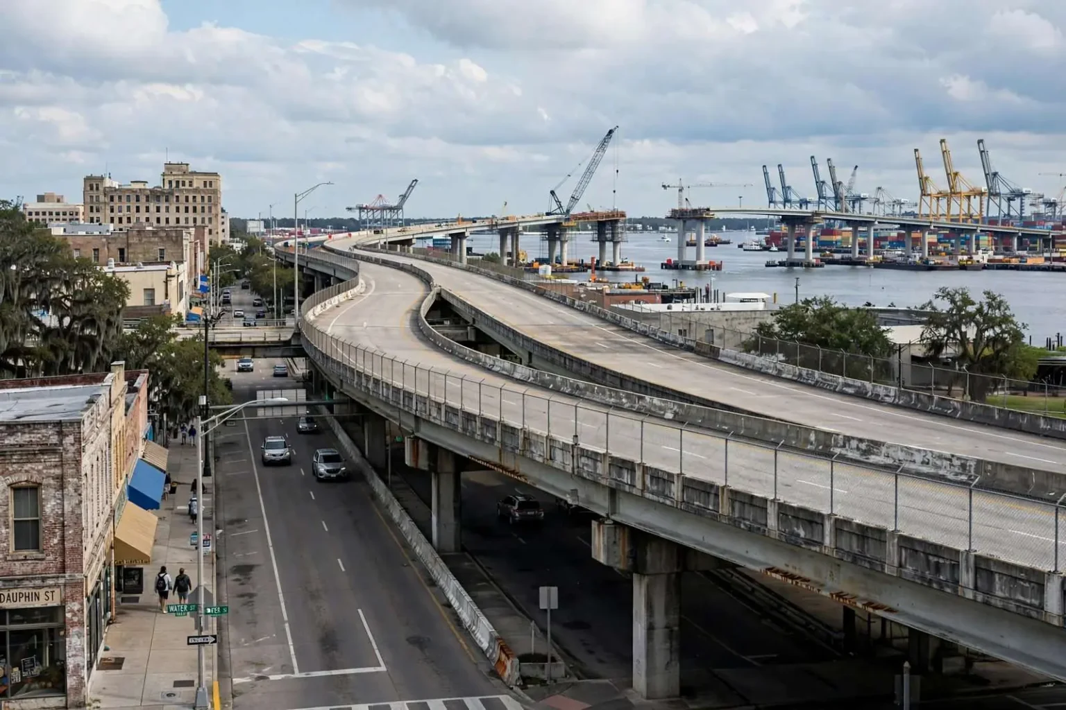
The long-awaited groundbreaking of a new Interstate 10 bridge over the Mobile River has given Mobile’s mayor an opening to revive one of the most ambitious ideas in the city’s downtown planning conversation: tearing out the elevated highway ramps that pour interstate traffic onto Water Street. Mayor Spiro Cheriogotis, reacting to the Alabama Department of Transportation’s announcement that the multi-billion-dollar Mobile River Bridge and Bayway project will finally break ground before the end of 2026, said he noticed something conspicuously absent from the digital renderings the state released alongside the news.
The on-ramps and off-ramps linking Water Street to I-10 simply were not there. “I don’t know if you saw the rendering that was released today, but those aren’t in that rendering,” the mayor said. “Part of the original plan was to take down that Water Street off-ramp and on-ramp. I would ultimately like to see that happen.”
The observation put a long-running planning debate back at the center of the city’s biggest infrastructure project. For decades, the pair of elevated ramps has chained I-10’s local traffic to the downtown riverfront, delivering high-speed interstate flows directly onto a street that planners have long argued should be the city’s great waterfront promenade. The new bridge and bayway — the largest transportation investment in the region’s history — will reroute interstate traffic over a new span and a rebuilt crossing of Mobile Bay, and the question Cheriogotis raised is what becomes of the old ramps once the through traffic moves onto the new crossing: infrastructure built for an obsolete traffic pattern, standing between downtown and its own waterfront.
A Riverfront Cut Off From the City
To understand why the ramps matter so much to city planners, it helps to understand what Water Street has become. The roadway runs along the eastern edge of downtown Mobile, separating the historic core of the city from the Mobile River and the port that made the city what it is. What could function as a riverfront promenade instead operates as a high-speed arterial, with wide lanes, fast-moving traffic and concrete overpasses that cast the sidewalks in shadow.
The result is a psychological and physical wall. Visitors who stroll through Dauphin Street’s restaurants and bars or tour the historic districts rarely walk the final few blocks east to the water, because doing so means crossing several lanes of traffic beneath an interstate structure. The disconnect is not subtle: a visitor standing at the foot of Dauphin Street can see the river’s edge a few blocks away, yet the walk requires navigating ramps, underpasses and roadway geometry built entirely for vehicles. For a city defined by its bay and its river, that disconnection has long been treated as a planning failure.
The failure carries measurable costs. Waterfront cities across the country have demonstrated that reconnecting downtowns to their harbors multiplies investment along the seam: restaurants fronting the water, hotels, museums, public gathering spaces. Mobile has invested heavily in its downtown core over the past two decades — restored historic blocks, an entertainment district, new residential development — but the waterfront seam has remained the unfinished edge, hemmed in by the interstate approach system. Every plan for extending downtown’s revival eastward has run into the same obstacle: the ramps and the traffic they carry.
The geography compounds the problem. Downtown Mobile’s street grid terminates at Water Street, where the elevated structures and the port’s working edge take over. Unlike cities whose waterfronts face open water, Mobile’s riverfront is an industrial working port — container cranes, cruise terminals, rail lines — and the interstate approach system sits directly on top of the transition between city and harbor. Reclaiming that seam requires not just traffic engineering but a reweaving of how the city, the port and the highway share the same narrow strip of land.
The Mayor’s Plan for Water Street
In March, Cheriogotis laid out a vision for reversing that. His administration proposed slowing traffic along Water Street and reorienting it from a high-speed interstate feeder into an urban waterfront street — narrower travel lanes, traffic calming, streetscape improvements that would make the walk from downtown to the water feel like a passage rather than a crossing. The plan treated Water Street as the city’s next great civic project: the ground-level street reopened to pedestrians, the overpasses removed or repurposed, and the blocks between Dauphin Street and the riverfront brought back into the fabric of downtown.
Removing the Water Street ramps would make that plan physically possible. With I-10’s through traffic carried by the new bridge and bayway, the downtown ramps’ original function — feeding interstate volumes into the city’s core — diminishes to local-access levels, and the structures themselves become removable. The mayor’s argument is that the renderings’ silence on the ramps suggests the state recognizes that future, and that the city should press to make the demolition explicit rather than incidental — a negotiated outcome of the bridge project rather than an aspiration left on a wish list.
The timing gives the argument leverage. The bridge and bayway project will consume the rest of this decade’s construction calendar, and decisions about what happens to the downtown approach system will be made during its design and staging phases — years in which Mobile’s municipal leadership has a seat at the table with the state. A mayor who wants the ramps gone has that window to convert the idea from rendering inference into committed scope, with funding mechanisms, demolition schedules and a redevelopment plan for the reclaimed land.
What Removing the Ramps Would Unlock
The redevelopment prize is substantial. The land occupied by elevated ramps and their support structures is downtown’s most strategically located underused space — blocks that, freed of overpasses, would connect the historic core directly to the waterfront corridor the city has been assembling. Planners who have studied the area describe the potential in concrete terms: through-blocks reclaimed for mixed-use development, a continuous waterfront promenade linking the cruise terminal to the historic districts, and street-level crossings that let a family walk from a Dauphin Street dinner to the river’s edge without crossing beneath interstate concrete.
Comparable transformations elsewhere provide the template. Cities that removed or capped urban highway segments — from Portland’s waterfront park to Milwaukee’s Park East corridor removal to the multi-city highway-teardown movement of the past decade — documented the pattern: reclaimed land appreciated sharply, adjacent property values rose, and pedestrian traffic between downtown and the water multiplied. Each case required the same precondition Mobile now faces — through traffic rerouted onto a new facility that makes the old one redundant. The Mobile River Bridge creates exactly that condition.
The port complicates and enriches the picture. Mobile’s harbor is a growing container gateway, and the ramps serve freight as well as commuters; any redesign must protect the truck movements that connect the interstate to the terminal areas. Planning that separates through-traffic functions — keeping efficient freight and interstate connections where they belong while stripping the downtown edge of high-speed cut-through — is the engineering core of the mayor’s vision, and the new bridge’s capacity is what makes the separation feasible for the first time.
The Bridge Project Itself
The Mobile River Bridge and Bayway project ranks among the largest transportation undertakings in the Gulf Coast’s history. Its purpose is structural: today’s I-10 crosses the Mobile River and Mobile Bay through the Bankhead Tunnel and the George Wallace Tunnel, twin under-river passages built in the middle of the twentieth century whose capacity, geometry and age have long constrained the region’s most important east-west corridor. Congestion through the tunnels during peak periods has become a defining experience of Mobile-area driving, and the corridor’s freight volumes have strained a crossing built for a different era.
The new configuration — a high-level bridge over the Mobile River and a rebuilt crossing of Mobile Bay — replaces that bottleneck with a modern facility, and its groundbreaking before the end of 2026 sets the region’s transportation calendar for the decade. The project’s scale means years of construction activity across the corridor, staging that will reshape traffic patterns long before the new crossings open, and coordination between the state, the city, the port and the railroads that share the riverfront right-of-way.
Within that enormous undertaking, the downtown ramps are a small but symbolically loaded element. Their fate determines whether the project delivers only a better interstate crossing — faster tunnel-free travel for through traffic — or also a remade downtown riverfront. Cheriogotis’s public pressure aims at the second outcome, arguing that the state’s own renderings hint at it and that the city should not let the question drift.
The Politics of a Rendering
The mayor’s use of the rendering as evidence is a classic negotiating move in infrastructure politics. Digital visualizations published by state transportation agencies are not commitments — they are illustrations of proposed configurations — but when a rendering omits a long-standing structure, it invites exactly the question Cheriogotis asked: is the state planning to remove it? By raising the question publicly, the mayor converted a rendering into an agenda item, forcing ALDOT to clarify whether the ramps’ absence reflects design intent or illustrative simplification.
The public stakes are easy to state. If the ramps come down as part of the bridge project, downtown Mobile gains waterfront access without the city spending its own capital budget on demolition — the work rides inside a multi-billion-dollar state program. If they remain, the city faces the far costlier prospect of pursuing removal on its own, and the waterfront seam stays blocked for another generation. The difference between those outcomes is why a mayor would spend political capital on the contents of a digital image.
For downtown’s businesses and residents, the ramp question joins the list of waterfront decisions — cruise terminal development, waterfront park planning, the port’s expansion — that will define Mobile’s next decades. The new bridge guarantees that I-10 traffic will move differently through the city; the open question is whether the city uses that disruption to finally undo the wall between itself and the river. Cheriogotis has put the answer on the public agenda before the first pile is driven, betting that the moment of maximum leverage — the project’s design years — is the moment to insist that Water Street’s future be drawn into the plan.